Western, Nebraska
Western is a village in Saline County, Nebraska, United States. The population was 235 at the 2010 census.
Western, Nebraska | |
|---|---|
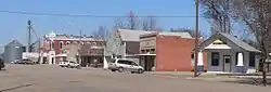 Downtown Western: east side of West Avenue | |
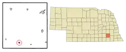 Location of Western, Nebraska | |
| Coordinates: 40°23′31″N 97°11′54″W | |
| Country | United States |
| State | Nebraska |
| County | Saline |
| Area | |
| • Total | 0.49 sq mi (1.26 km2) |
| • Land | 0.49 sq mi (1.26 km2) |
| • Water | 0.00 sq mi (0.00 km2) |
| Elevation | 1,493 ft (455 m) |
| Population | |
| • Total | 235 |
| • Estimate (2019)[3] | 232 |
| • Density | 477.37/sq mi (184.15/km2) |
| Time zone | UTC-6 (Central (CST)) |
| • Summer (DST) | UTC-5 (CDT) |
| ZIP code | 68464 |
| Area code(s) | 402 |
| FIPS code | 31-52295[4] |
| GNIS feature ID | 0834640[5] |
History
Western was laid out in 1872.[6] It was likely named for Wesley West, a pioneer settler.[7][6] Western was incorporated as a village in 1880.[6]
Geography
Western is located at 40°23′31″N 97°11′54″W (40.392050, -97.198259).[8]
According to the United States Census Bureau, the village has a total area of 0.49 square miles (1.27 km2), all land.[9]
Demographics
| Historical population | |||
|---|---|---|---|
| Census | Pop. | %± | |
| 1890 | 397 | — | |
| 1900 | 412 | 3.8% | |
| 1910 | 499 | 21.1% | |
| 1920 | 427 | −14.4% | |
| 1930 | 511 | 19.7% | |
| 1940 | 437 | −14.5% | |
| 1950 | 434 | −0.7% | |
| 1960 | 351 | −19.1% | |
| 1970 | 344 | −2.0% | |
| 1980 | 336 | −2.3% | |
| 1990 | 264 | −21.4% | |
| 2000 | 287 | 8.7% | |
| 2010 | 235 | −18.1% | |
| 2019 (est.) | 232 | [3] | −1.3% |
| U.S. Decennial Census[10] | |||
2010 census
As of the census[2] of 2010, there were 235 people, 111 households, and 69 families residing in the village. The population density was 479.6 inhabitants per square mile (185.2/km2). There were 140 housing units at an average density of 285.7 per square mile (110.3/km2). The racial makeup of the village was 94.9% White, 1.3% Asian, and 3.8% from other races. Hispanic or Latino of any race were 4.7% of the population.
There were 111 households, of which 20.7% had children under the age of 18 living with them, 53.2% were married couples living together, 6.3% had a female householder with no husband present, 2.7% had a male householder with no wife present, and 37.8% were non-families. 32.4% of all households were made up of individuals, and 13.5% had someone living alone who was 65 years of age or older. The average household size was 2.12 and the average family size was 2.68.
The median age in the village was 50.5 years. 18.7% of residents were under the age of 18; 3.9% were between the ages of 18 and 24; 20.1% were from 25 to 44; 36.2% were from 45 to 64; and 21.3% were 65 years of age or older. The gender makeup of the village was 48.1% male and 51.9% female.
2000 census
As of the census[4] of 2000, there were 287 people, 128 households, and 86 families residing in the village. The population density was 644.2 people per square mile (246.2/km2). There were 151 housing units at an average density of 338.9 per square mile (129.6/km2). The racial makeup of the village was 97.91% White, 0.70% Native American, and 1.39% from two or more races.
There were 128 households, out of which 24.2% had children under the age of 18 living with them, 59.4% were married couples living together, 3.9% had a female householder with no husband present, and 32.8% were non-families. 28.1% of all households were made up of individuals, and 18.0% had someone living alone who was 65 years of age or older. The average household size was 2.24 and the average family size was 2.73.
In the village, the population was spread out, with 21.3% under the age of 18, 6.3% from 18 to 24, 23.0% from 25 to 44, 19.9% from 45 to 64, and 29.6% who were 65 years of age or older. The median age was 44 years. For every 100 females, there were 86.4 males. For every 100 females wege 18 and over, there were 93.2 males.
As of 2000 the median income for a household in the village was $31,750, and the median income for a family was $41,250. Males had a median income of $26,250 versus $20,804 for females. The per capita income for the village was $16,175. About 2.6% of families and 2.1% of the population and 2.6% of families were below the poverty line, including none of those under the age of 18 and 7.1% of those 65 and older.
Education
Local children attend Meridian School or Tri County School.
References
- "2019 U.S. Gazetteer Files". United States Census Bureau. Retrieved July 26, 2020.
- "U.S. Census website". United States Census Bureau. Retrieved 2012-06-24.
- "Population and Housing Unit Estimates". United States Census Bureau. May 24, 2020. Retrieved May 27, 2020.
- "U.S. Census website". United States Census Bureau. Retrieved 2008-01-31.
- "US Board on Geographic Names". United States Geological Survey. 2007-10-25. Retrieved 2008-01-31.
- "Western, Saline". Center for Advanced Land Management Information Technologies. University of Nebraska. Retrieved 22 August 2014.
- Fitzpatrick, Lillian L. (1960). Nebraska Place-Names. University of Nebraska Press. p. 124. ISBN 0-8032-5060-6. A 1925 edition is available for download at University of Nebraska—Lincoln Digital Commons.
- "US Gazetteer files: 2010, 2000, and 1990". United States Census Bureau. 2011-02-12. Retrieved 2011-04-23.
- "US Gazetteer files 2010". United States Census Bureau. Retrieved 2012-06-24.
- "Census of Population and Housing". Census.gov. Retrieved June 4, 2015.
Municipalities and communities of Saline County, Nebraska, United States | ||
|---|---|---|
| Cities | Map of Nebraska highlighting Saline County | |
| Villages | ||
| Unincorporated communities | ||
| Footnotes | ‡This populated place also has portions in an adjacent county or counties | |
| ||