Friend, Nebraska
Friend is a city in Saline County, Nebraska, United States. As of the 2010 census, the city population was 1,027.
Friend, Nebraska | |
|---|---|
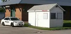 Friend police station | |
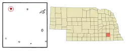 Location of Friend, Nebraska | |
| Coordinates: 40°39′8″N 97°17′9″W | |
| Country | United States |
| State | Nebraska |
| County | Saline |
| Area | |
| • Total | 0.83 sq mi (2.14 km2) |
| • Land | 0.83 sq mi (2.14 km2) |
| • Water | 0.00 sq mi (0.00 km2) |
| Elevation | 1,558 ft (475 m) |
| Population | |
| • Total | 1,027 |
| • Estimate (2019)[3] | 965 |
| • Density | 1,166.87/sq mi (450.52/km2) |
| Time zone | UTC-6 (Central (CST)) |
| • Summer (DST) | UTC-5 (CDT) |
| ZIP code | 68359 |
| Area code(s) | 402 |
| FIPS code | 31-17775 |
| GNIS feature ID | 0829421[4] |
| Website | http://www.ci.friend.ne.us/ |
History
The city is named for Charles E. Friend[5] who homesteaded the land and initially named the community Friendville. He operated a dry goods store and post office. In 1873 the Burlington and Missouri River Railroad named its new train station there "Friend."[6]
The National Greyhound Association was founded in the community in 1906 (called at the time National Coursing Association).[7]
The Friend Police Department, which was initially housed in a tool shed during construction of U.S. Route 6, was reported to be the smallest police station in the world according to Ripley's Believe It or Not. In the 1960s, the shed doubled in size so the Nebraska State Patrol could also be stationed there. Friend still claims to have the smallest combined police station.[8]
Geography
Friend is located at 40°39′8″N 97°17′9″W (40.652095, -97.285731).[9]
According to the United States Census Bureau, the city has a total area of 0.83 square miles (2.15 km2), all land.[10]
Demographics
| Historical population | |||
|---|---|---|---|
| Census | Pop. | %± | |
| 1880 | 555 | — | |
| 1890 | 1,347 | 142.7% | |
| 1900 | 1,200 | −10.9% | |
| 1910 | 1,261 | 5.1% | |
| 1920 | 1,263 | 0.2% | |
| 1930 | 1,214 | −3.9% | |
| 1940 | 1,169 | −3.7% | |
| 1950 | 1,148 | −1.8% | |
| 1960 | 1,069 | −6.9% | |
| 1970 | 1,126 | 5.3% | |
| 1980 | 1,079 | −4.2% | |
| 1990 | 1,111 | 3.0% | |
| 2000 | 1,174 | 5.7% | |
| 2010 | 1,027 | −12.5% | |
| 2019 (est.) | 965 | [3] | −6.0% |
| U.S. Decennial Census[11] | |||
2010 census
As of the census[2] of 2010, there were 1,027 people, 431 households, and 292 families residing in the city. The population density was 1,237.3 inhabitants per square mile (477.7/km2). There were 501 housing units at an average density of 603.6 per square mile (233.1/km2). The racial makeup of the city was 98.1% White, 0.4% African American, 0.1% Native American, 0.4% Asian, 0.4% from other races, and 0.6% from two or more races. Hispanic or Latino of any race were 2.4% of the population.
There were 431 households, of which 27.4% had children under the age of 18 living with them, 60.3% were married couples living together, 4.9% had a female householder with no husband present, 2.6% had a male householder with no wife present, and 32.3% were non-families. 30.2% of all households were made up of individuals, and 16% had someone living alone who was 65 years of age or older. The average household size was 2.30 and the average family size was 2.82.
The median age in the city was 47.9 years. 22.3% of residents were under the age of 18; 4% were between the ages of 18 and 24; 20% were from 25 to 44; 29% were from 45 to 64; and 24.7% were 65 years of age or older. The gender makeup of the city was 47.2% male and 52.8% female.
2000 census
As of the census of 2000, there were 1,174 people, 475 households, and 326 families residing in the city. The population density was 1,473.4 people per square mile (566.6/km2). There were 516 housing units at an average density of 647.6 per square mile (249.0/km2). The racial makeup of the city was 98.64% White, 0.26% Native American, 0.34% from other races, and 0.77% from two or more races. Hispanic or Latino of any race were 0.85% of the population.
There were 475 households, out of which 29.1% had children under the age of 18 living with them, 61.9% were married couples living together, 4.4% had a female householder with no husband present, and 31.2% were non-families. 29.1% of all households were made up of individuals, and 16.4% had someone living alone who was 65 years of age or older. The average household size was 2.36 and the average family size was 2.92.
In the city, the population was spread out, with 24.8% under the age of 18, 4.6% from 18 to 24, 22.1% from 25 to 44, 21.6% from 45 to 64, and 26.8% who were 65 years of age or older. The median age was 44 years. For every 100 females, there were 89.0 males. For every 100 females age 18 and over, there were 88.7 males.
As of 2000 the median income for a household in the city was $34,833, and the median income for a family was $40,667. Males had a median income of $32,946 versus $17,829 for females. The per capita income for the city was $17,422. About 4.9% of families and 6.8% of the population were below the poverty line, including 7.3% of those under age 18 and 6.5% of those age 65 or over.
Education
Friend Public Schools is the local school district.
Notable people
- Elvin C. Drake, head track and field coach of the 1956 NCAA Champion UCLA Bruins
- John L. Loos, American historian born in Friend in 1918
- Anna Louise Strong, journalist and left-wing activist
- Thad Weber, professional baseball player (San Diego Padres)
- John William Miller, aviation engineer
References
- "2019 U.S. Gazetteer Files". United States Census Bureau. Retrieved July 26, 2020.
- "U.S. Census website". United States Census Bureau. Retrieved 2012-06-24.
- "Population and Housing Unit Estimates". United States Census Bureau. May 24, 2020. Retrieved May 27, 2020.
- "US Board on Geographic Names". United States Geological Survey. 2007-10-25. Retrieved 2008-01-31.
- Gannett, Henry (1905). The Origin of Certain Place Names in the United States. Govt. Print. Off. pp. 132.
- "Friend, Nebraska -ci.friend.ne.us". Archived from the original on 2010-06-28. Retrieved 2009-01-28.
- History of the Greyhound and Greyhound Racing - The Greyhound Review, February 2006
- Friend, Nebraska -ci.friend.ne.us
- "US Gazetteer files: 2010, 2000, and 1990". United States Census Bureau. 2011-02-12. Retrieved 2011-04-23.
- "US Gazetteer files 2010". United States Census Bureau. Archived from the original on 2012-07-02. Retrieved 2012-06-24.
- United States Census Bureau. "Census of Population and Housing". Retrieved October 16, 2013.
External links
Municipalities and communities of Saline County, Nebraska, United States | ||
|---|---|---|
| Cities | Map of Nebraska highlighting Saline County | |
| Villages | ||
| Unincorporated communities | ||
| Footnotes | ‡This populated place also has portions in an adjacent county or counties | |
| ||