Williams, Oregon
Williams is an unincorporated community and census-designated place (CDP) in Josephine County, Oregon, United States. As of the 2010 census it had a population of 1,072.[1]
Williams, Oregon | |
|---|---|
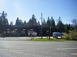 Williams Country Store | |
 Williams  Williams | |
| Coordinates: 42°13′8″N 123°16′24″W | |
| Country | United States |
| State | Oregon |
| County | Josephine |
| Settled | 1881 |
| Area | |
| • Total | 11.32 sq mi (29.33 km2) |
| • Land | 11.32 sq mi (29.33 km2) |
| • Water | 0.0 sq mi (0.0 km2) |
| Elevation | 1,380 ft (420 m) |
| Population (2010) | |
| • Total | 1,072 |
| • Density | 95/sq mi (37/km2) |
| Time zone | UTC-8 (Pacific) |
| • Summer (DST) | UTC-7 (Pacific) |
| ZIP code | 97544 |
| Area code(s) | 541 |
| FIPS code | 41-82450 |
| GNIS feature ID | 1152385 |
There were three different post offices in the area named for their proximity to Williams Creek: Williams, Williamsburg and Williams Creek (in Jackson County).[2] Williams Creek, which flows into the Applegate River, was named for Captain Robert Williams, who fought with Rogue River Indians along the creek during the Rogue River Wars of 1855–6.[2] Williams post office was established in 1881 and is about six miles upstream from Provolt on Williams Creek, and two miles west of the Jackson-Josephine county line.[2] The community is served by the Three Rivers School District; Williams Elementary School is located in the community.
Geography
Williams is in southeastern Josephine County, in the valley of Williams Creek, a north-flowing tributary of the Applegate River and part of the Rogue River watershed. It sits to the northeast of the Siskiyou Mountains and is 6 miles (10 km) south of Provolt and 19 miles (31 km) south of Grants Pass, the Josephine county seat.
According to the U.S. Census Bureau, the Williams CDP has an area of 11.3 square miles (29.3 km2), all of it recorded as land.[1]
Climate
This region experiences warm (but not hot) and dry summers, with no average monthly temperatures above 71.6 °F. According to the Köppen Climate Classification system, Williams has a warm-summer Mediterranean climate, abbreviated "Csb" on climate maps.[3]
| Climate data for Williams | |||||||||||||
|---|---|---|---|---|---|---|---|---|---|---|---|---|---|
| Month | Jan | Feb | Mar | Apr | May | Jun | Jul | Aug | Sep | Oct | Nov | Dec | Year |
| Record high °F (°C) | 60 (16) |
68 (20) |
74 (23) |
87 (31) |
92 (33) |
95 (35) |
102 (39) |
101 (38) |
98 (37) |
89 (32) |
68 (20) |
61 (16) |
102 (39) |
| Average high °F (°C) | 46.7 (8.2) |
51 (11) |
55.7 (13.2) |
62.9 (17.2) |
68.7 (20.4) |
77.3 (25.2) |
84.5 (29.2) |
83.3 (28.5) |
76.1 (24.5) |
66.2 (19.0) |
53.9 (12.2) |
47 (8) |
64.4 (18.0) |
| Average low °F (°C) | 31.2 (−0.4) |
30.6 (−0.8) |
33.1 (0.6) |
36 (2) |
40.9 (4.9) |
45 (7) |
48.6 (9.2) |
48.2 (9.0) |
43.5 (6.4) |
37.4 (3.0) |
32.8 (0.4) |
31.5 (−0.3) |
38.2 (3.4) |
| Record low °F (°C) | 15 (−9) |
4 (−16) |
19 (−7) |
22 (−6) |
26 (−3) |
5 (−15) |
35 (2) |
35 (2) |
29 (−2) |
22 (−6) |
10 (−12) |
14 (−10) |
4 (−16) |
| Average precipitation inches (mm) | 6.15 (156) |
3.99 (101) |
3.67 (93) |
1.92 (49) |
1.43 (36) |
0.64 (16) |
0.25 (6.4) |
0.38 (9.7) |
0.73 (19) |
2.25 (57) |
5.09 (129) |
6.63 (168) |
33.12 (841) |
| Average snowfall inches (cm) | 4.3 (11) |
2.2 (5.6) |
1.8 (4.6) |
0.2 (0.51) |
0 (0) |
0 (0) |
0 (0) |
0 (0) |
0 (0) |
0 (0) |
0.5 (1.3) |
2.5 (6.4) |
11.5 (29) |
| Average precipitation days | 14 | 11 | 13 | 10 | 8 | 4 | 1 | 2 | 4 | 7 | 12 | 14 | 100 |
| Source: [4] | |||||||||||||
References
- "Geographic Identifiers: 2010 Census Summary File 1 (G001): Williams CDP, Oregon". American Factfinder. U.S. Census Bureau. Archived from the original on February 13, 2020. Retrieved November 2, 2018.
- McArthur, Lewis A.; McArthur, Lewis L. (2003) [1928]. Oregon Geographic Names (7th ed.). Portland, Oregon: Oregon Historical Society Press. pp. 1041–1043. ISBN 978-0875952772.
- Climate Summary for Williams, Oregon
- "WILLIAMS 1 NW, OR (359390)". Western Regional Climate Center. Retrieved November 26, 2015.
Municipalities and communities of Josephine County, Oregon, United States | ||
|---|---|---|
| Cities | 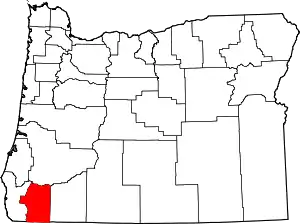 Josephine County map | |
| CDPs | ||
| Other unincorporated communities | ||
| Ghost towns | ||
| ||