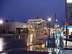
Grants Pass, Oregon
Grants Pass is the county seat of Josephine County, Oregon, United States.[8] The city is located on Interstate 5, northwest of Medford, along the Rogue River. The population was 34,533 at the 2010 census.[9]
Grants Pass, Oregon | |
|---|---|
| City of Grants Pass, Oregon | |
 | |
| Motto(s): Live Rogue; It's the Climate! | |
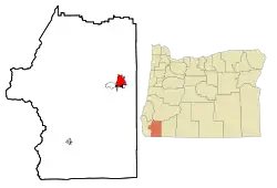 Location in Josephine County and the state of Oregon | |
 Grants Pass, Oregon Location in USA | |
| Coordinates: 42°26′20″N 123°19′42″W | |
| Country | United States |
| State | Oregon |
| County | Josephine |
| Incorporated | 1887 |
| Government | |
| • Mayor | Sara Bristol[1] |
| • City Manager | Aaron Cubic[2] |
| Area | |
| • Total | 11.68 sq mi (30.25 km2) |
| • Land | 11.52 sq mi (29.83 km2) |
| • Water | 0.16 sq mi (0.42 km2) |
| Elevation | 960 ft (290 m) |
| Population | |
| • Total | 34,533 |
| • Estimate (2019)[5] | 38,170 |
| • Density | 3,313.66/sq mi (1,279.43/km2) |
| Time zone | UTC−8 (Pacific) |
| • Summer (DST) | UTC−7 (Pacific) |
| ZIP codes | 97526, 97527, 97528, 97543 |
| Area codes | 541 and 458 |
| FIPS code | 41-30550[6] |
| GNIS feature ID | 1142947[7] |
| Website | www |
History
Early Hudson's Bay Company hunters and trappers, following the Siskiyou Trail, passed through the site beginning in the 1820s. In the late 1840s, settlers (mostly American) following the Applegate Trail began traveling through the area on their way to the Willamette Valley. The city states[10] that the name was selected to honor General Ulysses S. Grant's success at Vicksburg. The Grants Pass post office was established on March 22, 1865.[11] The city of Grants Pass was incorporated in 1887.[12]
The Oregon–Utah Sugar Company, financed by Charles W. Nibley, was created, leading to a sugar beet factory being built in Grants Pass in 1916.[13] Before the factory opened, Oregon-Utah Sugar was merged into the Utah-Idaho Sugar Company.[13] Due to labor shortages and low acreage planted in sugar beets, the processing machinery was moved to Toppenish, Washington, in 1918 or 1919.[13]
Grants Pass is one of many cities in Oregon that is marked by a racist history. Grants Pass, along with Medford and Ashland was an unofficial "sundown town", which actively warned Black and other non-white people to leave town before sunset or face violence and harassment. Although there was no documented law of the racist policy, it was enforced locally via residents and signage.[14][15]
Geography
Grants Pass is located in the Rogue Valley; the Rogue River runs through the city. U.S. Route 199 passes through the city, and joins Interstate 5.
According to the United States Census Bureau, the city has a total area of 11.03 square miles (28.57 km2), of which, 10.87 square miles (28.15 km2) is land and 0.16 square miles (0.41 km2) is water.[16]
Climate
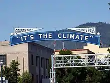
True to its motto, "It's the climate!",[17] Grants Pass has a Sunset Zone 7 climate.[18] According to the Köppen climate classification system, Grants Pass has a hot-summer Mediterranean climate (Csa).
Summer days are sunny, dry and hot, with dramatic cooling at night; the average August high temperature is 88.8 °F or 31.6 °C, but the low is only 53.7 °F or 12.1 °C. Winters are cool and fairly rainy, with only occasional snow; the average January high temperature is 46.6 °F or 8.1 °C and the low, 35.1 °F or 1.7 °C. Grants Pass receives roughly 31 inches or 790 millimetres precipitation per year, with three-quarters of it occurring between November 1 and March 31. The mild winters and dry summers support a native vegetation structure quite different from the rest of Oregon, dominated by madrone, deciduous and evergreen oak, manzanita, pine, bush chinquapin, and other species that are far less abundant further north.[19]
The record high temperature of 114 °F or 45.6 °C was on July 23, 1928. The record low temperature of −1 °F (−18.3 °C) was on December 9, 1972[20] until 1990 when it reached −3 °F (−19.4 °C).[21] There are an average of 51.3 afternoons annually with highs of 90 °F or 32.2 °C or higher, eight afternoons reaching at least 100 °F or 37.8 °C and 77.5 mornings annually with lows of 32 °F or 0 °C or lower.
Measurable precipitation falls on an average of 110 days annually. The wettest "rain year" on record was from July 1955 to June 1956 with 50.69 inches (1,287.5 mm) of precipitation, and the driest from July 1923 to June 1924 with 13.43 inches (341.1 mm). The most precipitation in one month was 20.63 inches (524.0 mm) in December 1996, and the most precipitation in one day 5.27 inches (133.9 mm) on October 29, 1950 — part of a two-day fall of 9.38 inches (238.3 mm) and ending a five-day fall of 11.26 inches or 286.0 millimetres. There is an average of only 4.6 inches or 0.12 metres of snow annually. The most snowfall in one month was 34.1 inches (0.87 m) in February 1917.[22]
| Climate data for Grants Pass, Oregon (1981–2010 normals) | |||||||||||||
|---|---|---|---|---|---|---|---|---|---|---|---|---|---|
| Month | Jan | Feb | Mar | Apr | May | Jun | Jul | Aug | Sep | Oct | Nov | Dec | Year |
| Record high °F (°C) | 71 (22) |
76 (24) |
86 (30) |
98 (37) |
102 (39) |
110 (43) |
114 (46) |
111 (44) |
108 (42) |
99 (37) |
77 (25) |
75 (24) |
114 (46) |
| Average high °F (°C) | 46.6 (8.1) |
52.9 (11.6) |
58.8 (14.9) |
64.4 (18.0) |
72.4 (22.4) |
79.7 (26.5) |
88.5 (31.4) |
88.8 (31.6) |
82.2 (27.9) |
69.1 (20.6) |
52.1 (11.2) |
44.3 (6.8) |
66.7 (19.3) |
| Daily mean °F (°C) | 40.9 (4.9) |
44.3 (6.8) |
48.1 (8.9) |
52.2 (11.2) |
58.8 (14.9) |
65.1 (18.4) |
71.8 (22.1) |
71.3 (21.8) |
64.7 (18.2) |
55.2 (12.9) |
45.4 (7.4) |
39.8 (4.3) |
54.8 (12.7) |
| Average low °F (°C) | 35.1 (1.7) |
35.7 (2.1) |
37.3 (2.9) |
39.9 (4.4) |
45.2 (7.3) |
50.4 (10.2) |
55.0 (12.8) |
53.7 (12.1) |
47.2 (8.4) |
41.3 (5.2) |
38.7 (3.7) |
35.3 (1.8) |
42.9 (6.1) |
| Record low °F (°C) | 1 (−17) |
5 (−15) |
15 (−9) |
20 (−7) |
24 (−4) |
30 (−1) |
35 (2) |
30 (−1) |
24 (−4) |
20 (−7) |
12 (−11) |
−1 (−18) |
−1 (−18) |
| Average precipitation inches (mm) | 4.77 (121) |
3.95 (100) |
3.38 (86) |
2.12 (54) |
1.36 (35) |
0.68 (17) |
0.32 (8.1) |
0.30 (7.6) |
0.64 (16) |
1.93 (49) |
5.04 (128) |
6.49 (165) |
30.98 (787) |
| Average snowfall inches (cm) | 0.4 (1.0) |
0.2 (0.51) |
0 (0) |
0 (0) |
0 (0) |
0 (0) |
0 (0) |
0 (0) |
0 (0) |
0 (0) |
0 (0) |
0.3 (0.76) |
0.9 (2.27) |
| Average precipitation days (≥ 0.01 in) | 16.7 | 14.2 | 15.7 | 12.4 | 8.6 | 4.5 | 1.8 | 2.0 | 3.5 | 8.0 | 17.0 | 17.4 | 121.8 |
| Average snowy days (≥ 0.1 in) | 0.3 | 0.3 | 0.1 | 0 | 0 | 0 | 0 | 0 | 0 | 0 | 0.1 | 0.3 | 1.1 |
| Source: NOAA [23] | |||||||||||||
Demographics
| Historical population | |||
|---|---|---|---|
| Census | Pop. | %± | |
| 1880 | 250 | — | |
| 1890 | 1,432 | 472.8% | |
| 1900 | 2,290 | 59.9% | |
| 1910 | 3,897 | 70.2% | |
| 1920 | 4,200 | 7.8% | |
| 1930 | 4,666 | 11.1% | |
| 1940 | 6,028 | 29.2% | |
| 1950 | 8,116 | 34.6% | |
| 1960 | 10,118 | 24.7% | |
| 1970 | 12,455 | 23.1% | |
| 1980 | 14,977 | 20.2% | |
| 1990 | 17,488 | 16.8% | |
| 2000 | 23,003 | 31.5% | |
| 2010 | 34,533 | 50.1% | |
| 2019 (est.) | 38,170 | [5] | 10.5% |
| Source:[24] 2018 Estimate[26] | |||
2010 census
As of the census of 2010,[4] there were 34,533 people, 14,313 households, and 8,700 families residing in the city. The population density was 3,176.9 inhabitants per square mile (1,226.6/km2). There were 15,561 housing units at an average density of 1,431.6 per square mile (552.7/km2). The racial makeup of the city was 90.9% White, 0.5% African American, 1.2% Native American, 1.1% Asian, 0.3% Pacific Islander, 2.3% from other races, and 3.7% from two or more races. Hispanic or Latino of any race were 8.5% of the population.
There were 14,313 households, of which 30.7% had children under the age of 18 living with them, 41.3% were married couples living together, 14.5% had a female householder with no husband present, 4.9% had a male householder with no wife present, and 39.2% were non-families. 32.8% of all households were made up of individuals, and 16.3% had someone living alone who was 65 years of age or older. The average household size was 2.34 and the average family size was 2.94.
The median age in the city was 39.3 years. 24.3% of residents were under the age of 18; 8.4% were between the ages of 18 and 24; 23.6% were from 25 to 44; 25% were from 45 to 64; and 18.6% were 65 years of age or older. The gender makeup of the city was 47.3% male and 52.7% female.
2000 census
As of the census[6] of 2000, there were 23,003 people, 9,376 households, and 5,925 families residing in the city. The population density was 3,033 per square mile (7,855/km2). There were 9,885 housing units at an average density of 1,303.3 per square mile (503.5/km2). By 2008, the city's population had increased to 33,239. According to U.S. Census figures from the 2006-2008 American Community Survey, the racial composition of the city's population was 93.6% white, 0.2% black, 1.6% American Indian, 1.1% Asian, 1.2% other race, and 2.3% two or more races. Hispanics or Latinos, who may be of any race, formed 7.2% of the city's population.
There were 9,376 households, out of which 31.1% had children under the age of 18 living with them, 44.5% were married couples living together, 14.5% had a female householder with no husband present, and 36.8% were non-families. 31.2% of all households were made up of individuals, and 16.0% had someone living alone who was 65 years of age or older. The average household size was 2.36 and the average family size was 2.94.
In the city, the population was spread out, with 26.0% under the age of 18, 8.1% from 18 to 24, 25.7% from 25 to 44, 20.7% from 45 to 64, and 19.4% who were 65 years of age or older. The median age was 38 years. For every 100 females, there were 86.8 males. For every 100 females age 18 and over, there were 80.7 males.
The median income for a household in the city was $29,197, and the median income for a family was $36,284. Males had a median income of $31,128 versus $23,579 for females. The per capita income for the city was $16,234. About 12.2% of families and 34.9% of the population were below the poverty line, including 20.8% of those under age 18 and 7.3% of those age 65 or over.
Government and politics
The city council has 8 members as of 2019, representing 4 wards and are elected to 4 year terms by the city. The city council and mayor are not paid, and they volunteer their time. The council oversees the city government and chooses the city manager. The Mayor's job is to provide leadership and preside over city council meetings. The Mayor can also issue vetoes and make a tiebreaker vote. Grants Pass is conservative leaning and represented in the United States House of Representatives by congressman Greg Walden (R-Hood River). Grants Pass is represented in the Oregon Senate by Republican Herman Baertschiger, and represented in the Oregon House of Representatives by Republican Carl Wilson.
Economy
The lumber industry was the major employer for Grants Pass up until the early 1970s. At that point the entire region started to see a steady decline in all lumber harvesting, production, and processing. Since then there has been a shift to a large service industry sector covering areas of outdoors/sports/recreation and health care infrastructure. This is augmented by multiple small and medium businesses and growth in marijuana-related businesses due to state legalization.
Notable businesses
Grants Pass is the birthplace of Dutch Bros. Coffee, which began with a single small pushcart on the corner of 6th and G Streets, where the downtown stand is now located.[27] Brothers Travis and Dane Boersma started the franchise in 1992 and it quickly spread throughout the region.[27]
Fire Mountain Gems has been operating in Josephine county since 1986 and moved to Grants Pass in 2000.[28] They are a well-known direct marketing company, providing jewelry-making supplies to designer-artists around the world.[28]
Arts and culture
Annual cultural events
Boatnik, a speedboat race and carnival event, is held every Memorial Day weekend in Riverside Park.[29]
Museums and other points of interest
The historic Rogue Theatre downtown has been transformed into a performing arts venue that hosts mostly local acts.[30] The Grants Pass Towne Center Association's "Back to the '50s" Celebration includes free concerts, a nearly 600-vehicle Classic Car Cruise, poker runs, and thematic shopping in the town's downtown historic district.[31]
Year round, there are First Friday Art Nights. On the first Friday of every month, many of the city's downtown stores hold art shows and promotional events.[32]
The Grants Pass post office contains two tempera murals done through the U.S. Treasury Department Section on Fine Arts (often mistakenly referred to as the "WPA"), both painted in 1938. There are ten government-sponsored New Deal era murals in Oregon; Grants Pass is the only post office that contains two. The murals are "Rogue River Indians" by Louis DeMott Bunce (who also painted a 1959 mural at Portland International Airport) and "Early and Contemporary Industries" by Eric Lamade.[33]
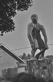
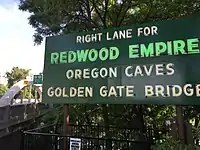
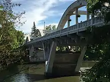
The Caveman Bridge on 6th Street was built by Conde McCullough in 1933. The through arch design bridge has been a landmark of Grants Pass for many years, and the bridge was refurbished in 2019. The Redwood Empire sign at the beginning of the bridge has also been a landmark for many years, and neon lighting was added in 2019.
Parks and recreation
Grants Pass has numerous and diverse parks and green spaces.[34] Notable city-run parks include Riverside Park, summer home to the local Concerts in the Park series, and the Reinhart Volunteer Park, a park largely built through the efforts of community volunteers and featuring facilities for many sports.[35][36] Grants Pass is a Tree City USA Community and has been for 29 years.[37]
Education
Grants Pass area public schools are served by Grants Pass School District, including Grants Pass High School, and Three Rivers School District, including Illinois Valley High School, North Valley High School, and Hidden Valley High School. Rogue Community College's (RCC) main (Redwood Campus) is located south of Grants Pass on Redwood Highway with additional campuses located in Medford, Oregon (Riverside Campus) and White City (Table Rock Campus).[38]
Law enforcement
The City of Grants Pass is served by a Department of Public Safety rather than by traditional police and fire departments.[39]
Media
Newspapers
The Grants Pass Daily Courier is the region's newspaper. The newspaper was established in 1885 with the name "Grant's Pass Courier" and then "Rogue River Courier." After the newspaper became a daily, the name was changed to what it is today. The other paper of record in Josephine County is the Illinois Valley News in Cave Junction established in 1937.
Radio
- AM
- FM
(Medford and Ashland stations listed by Grants Pass translator frequencies)
- KDOV 88.1 Religious
- KLXG 91.1 K-LOVE — Religious
- KTMT-FM 92.1 Top 40
- KIFS 93.1 Top 40
- KRRM 94.7 Traditional Country
- KBOY-FM 96.1 Classic Rock
- KROG 96.9 The Rogue — Active Rock
- KLDR 98.3 Top 40
- KRWQ 98.7 Country
- KCMD 99.3 News/Talk
- KLDZ 100.7 Classic Hits
- KSOR 101.5 JPR Classical
- KCNA 102.7 The Drive — Classic Hits
- KAWZ 103.1 CSN — Religious
- KAKT 104.7 Country
- KYVL 106.3 Adult Album Alternative
- KCGP-LP 106.7 Christian
- KCMX-FM 107.1 Adult Contemporary
- KJCR-LP 107.9 Catholic Talk
Transportation
Bus
Notable people
- David Anders, actor[40]
- Agnes Baker Pilgrim, Chairperson, International Council of Thirteen Indigenous Grandmothers[41]
- Carl Barks, writer and artist[42]
- Ty Burrell, actor
- Kit Culkin, actor
- Brandon Drury, baseball player
- David Goines, artist, writer
- Helen Chenoweth-Hage, U.S. Representative from Idaho
- Kevin Hagen, actor
- Jack Lee Harelson, archaeological looter
- Charles Levin, actor
- Jim McDonald, baseball player
- Merrill McPeak, former Chief of Staff of the United States Air Force
- Scott O'Hara, pornographic actor and poet[43]
- Hub Pernoll, baseball player
- Michael Saucedo, actor, musician
- Josh Saunders, soccer player (goalkeeper)
- Shelley Shannon, anti-abortion activist, convicted arsonist and attempted murderer.
- Cornelius Sidler, Wisconsin State Assemblyman and lawyer[44]
- Ken Williams, baseball player
National Football League (NFL) players
Sister city
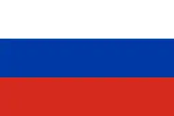 Rubtsovsk, Altai Krai, Russia[45]
See also
- Southern Oregon
- Rogue River – Siskiyou National Forest
- Jefferson (proposed Pacific state), proposed state overlapping Oregon and California
References
- https://www.grantspassoregon.gov/directory.aspx?eid=296
- https://www.grantspassoregon.gov/directory.aspx?eid=154
- "2019 U.S. Gazetteer Files". United States Census Bureau. Retrieved July 28, 2020.
- "U.S. Census website". United States Census Bureau. Retrieved 2012-12-21.
- "Population and Housing Unit Estimates". United States Census Bureau. May 24, 2020. Retrieved May 27, 2020.
- "U.S. Census website". United States Census Bureau. Retrieved 2008-01-31.
- "US Board on Geographic Names". United States Geological Survey. 2007-10-25. Retrieved 2008-01-31.
- "Find a County". National Association of Counties. Archived from the original on 2011-05-31. Retrieved 2011-06-07.
- Row, D.K. (23 February 2011). "Interpreting Oregon's population shift from the 2010 Census". The Oregonian. Retrieved 13 March 2011.
- "Archived copy". Archived from the original on 2011-07-21. Retrieved 2010-08-06.CS1 maint: archived copy as title (link)
- "Archived copy". Archived from the original on 2015-02-02. Retrieved 2015-03-07.CS1 maint: archived copy as title (link)
- "Archived copy". Archived from the original on 2012-01-25. Retrieved 2013-04-09.CS1 maint: archived copy as title (link)
- Arrington, Leonard J. (1966). Beet sugar in the West; a history of the Utah-Idaho Sugar Company, 1891-1966. University of Washington Press. p. 84. OCLC 234150.
- "Just People Like Us". oregonhumanities.org. Retrieved 2020-06-28.
- sundown.tougaloo.edu https://sundown.tougaloo.edu/sundowntownsshow.php?id=844. Retrieved 2020-06-28. Missing or empty
|title=(help) - "US Gazetteer files 2010". United States Census Bureau. Archived from the original on 2012-01-25. Retrieved 2012-12-21.
- "Archived copy". Archived from the original on 2012-08-07. Retrieved 2013-04-17.CS1 maint: archived copy as title (link)
- http://oregonstate.edu/dept/ldplants/sunsetzn.htm
- http://www.worldclimate.com/cgi-bin/data.pl?ref=N42W123+2200+353445C
- http://www.weather.com/weather/wxclimatology/monthly/graph/97526
- "Archived copy". Archived from the original on 2012-05-06. Retrieved 2013-04-17.CS1 maint: archived copy as title (link)
- http://www.wrcc.dri.edu/cgi-bin/cliMAIN.pl?or3445
- "NowData - NOAA Online Weather Data". National Oceanic and Atmospheric Administration. Retrieved 2012-04-15.
- Moffatt, Riley. Population History of Western U.S. Cities & Towns, 1850-1990. Lanham: Scarecrow, 1996, 210.
- United States Census Bureau. "Census of Population and Housing". Retrieved October 3, 2014.
- "Population Estimates". United States Census Bureau. Retrieved June 8, 2018.
- http://www.dutchbros.com
- http://www.firemountaingems.com/
- Boatnik
- Rogue Theatre
- Grants Pass Towne Center Association - Association of Grants Pass Merchants and Businesses Supporting Grants Pass Oregon Business, Businesses and Community
- First Friday Art Night Grants Pass Oregon Art Walk with Regional Southern Oregon Artists
- http://www.wpamurals.com/GrantsPs.htm
- "Grants Pass Parks". City of Grants Pass. Archived from the original on 2008-12-06. Retrieved 2008-01-31.
- "Grants Pass Parks". City of Grants Pass. Archived from the original on 2009-04-15. Retrieved 2009-04-01.
- "Grants Pass Parks". City of Grants Pass. Archived from the original on 2009-04-15. Retrieved 2009-04-01.
- "Grants Pass Tree Program". City of Grants Pass. Retrieved 2017-09-10.
- Rogue Community College
- "Public Safety | Grants Pass, OR - Official Website". www.grantspassoregon.gov. Retrieved 2020-07-04.
- Stafford, Nikki; Burnett, Robyn (2004). Uncovering Alias: An Unofficial Guide. ECW Press. p. 147. ISBN 9781550226539.
- "Grandmother Agnes Baker Pilgrim". International Council of Thirteen Indigenous Grandmothers. Retrieved 2014-08-09.
- Barrier, Michael (July 2014). "Thoughts on Carl Barks's Hundredth Birthday". Michael Barrier.
- Zeeland, Steven (2014). Dececco, John; Streit, Samuel A (eds.). Foreword. Rarely Pure and Never Simple: Selected Essays of Scott O'Hara. Routledge. p. x. ISBN 9781317790075.
- 'Former State Assemblyman Of 2nd District Dies,' Sheboygan Press, September 22, 1925, pg. 4
- "Archived copy". Archived from the original on 2005-08-28. Retrieved 2020-01-02.CS1 maint: archived copy as title (link)
External links
| Wikimedia Commons has media related to Grants Pass, Oregon. |
| Wikivoyage has a travel guide for Grants Pass, Oregon. |
Municipalities and communities of Josephine County, Oregon, United States | ||
|---|---|---|
| Cities | 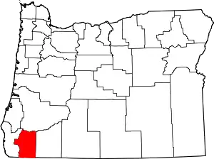 Josephine County map | |
| CDPs | ||
| Other unincorporated communities | ||
| Ghost towns | ||
| ||

| Authority control |
|---|