Winwill, Queensland
Winwill is a rural locality in the Lockyer Valley Region, Queensland, Australia.[2] In the 2016 census, Winwill had a population of 149 people.[1]
| Winwill Queensland | |||||||||||||||
|---|---|---|---|---|---|---|---|---|---|---|---|---|---|---|---|
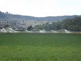 Irrigated crops, 2014 | |||||||||||||||
 Winwill | |||||||||||||||
| Coordinates | 27.6061°S 152.2091°E | ||||||||||||||
| Population | 149 (2016 census)[1] | ||||||||||||||
| • Density | 24.43/km2 (63.3/sq mi) | ||||||||||||||
| Postcode(s) | 4347 | ||||||||||||||
| Area | 6.1 km2 (2.4 sq mi) | ||||||||||||||
| Time zone | AEST (UTC+10:00) | ||||||||||||||
| Location | |||||||||||||||
| LGA(s) | Lockyer Valley Region | ||||||||||||||
| State electorate(s) | Lockyer | ||||||||||||||
| Federal Division(s) | Wright | ||||||||||||||
| |||||||||||||||
Geography
The eastern boundary of Winwill follows Tenthill Creek and Ma Ma Creek marks a small section of the western boundary. The Gatton Clifton Road (State Route 80) passes through from north-east to south. The north and west of the locality is mostly rural residential while the eastern and southern parts of the locality are used for irrigated cropping.[3]
History
At the 2011 census the population of Winwill was not separately recorded but included within the population of 403 at Ma Ma Creek.[4]
Education
There are no schools in Winwill. There are primary schools in neighbouring Grantham, Lower Tenthill and Ma Ma Creek. The nearest secondary school is Lockyer District State High School in Gatton.[3]
References
- Australian Bureau of Statistics (27 June 2017). "Winwill (SSC)". 2016 Census QuickStats. Retrieved 20 October 2018.

- "Winwill – locality in Lockyer Valley Region (entry 44999)". Queensland Place Names. Queensland Government. Retrieved 11 June 2019.
- "Queensland Globe". State of Queensland. Retrieved 10 October 2019.
- Australian Bureau of Statistics (31 October 2012). "Ma Ma Creek (State Suburb)". 2011 Census QuickStats. Retrieved 15 October 2014.