Lockyer Valley Region
The Lockyer Valley Region is a local government area in the West Moreton region of South East Queensland, Australia, between the cities of Ipswich and Toowoomba. It was created in 2008 from a merger of the Shire of Gatton and the Shire of Laidley. Steve Jones, former mayor of Gatton, was elected as first mayor of the Lockyer Valley Region.[2]
| Lockyer Valley Region Queensland | |||||||||||||||
|---|---|---|---|---|---|---|---|---|---|---|---|---|---|---|---|
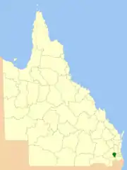 Location within Queensland | |||||||||||||||
| Population | 41,011 (2018)[1] | ||||||||||||||
| • Density | 18.074/km2 (46.813/sq mi) | ||||||||||||||
| Established | 2008 | ||||||||||||||
| Area | 2,269 km2 (876.1 sq mi)[1] | ||||||||||||||
| Mayor | Tanya Milligan | ||||||||||||||
| Council seat | Gatton | ||||||||||||||
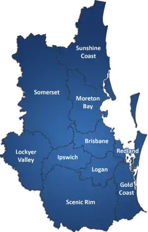
| Region | West Moreton | ||||||||||||||
| State electorate(s) | Lockyer | ||||||||||||||
| Federal Division(s) | Wright | ||||||||||||||
| Website | Lockyer Valley Region | ||||||||||||||
| |||||||||||||||
It has an estimated operating budget of A$35m.
History
Prior to 2008, the new Lockyer Valley Region was an entire area of two previous and distinct local government areas:
- the Shire of Gatton;
- and the Shire of Laidley.
Prior to European settlement, the Lockyer Valley area was home to the Kitabul Aboriginal people.
Tarampa Divisional Board was created on 15 January 1880 under the Divisional Boards Act 1879, and held its first meeting on 20 February 1880. On 25 April 1888, the Laidley area broke away and separately incorporated, and on 25 January 1890, the Forest Hill area moved from Tarampa to Laidley.[3] On 1 July 1902, the town of Laidley was created as a separate municipality with its own Borough Council.
With the passage of the Local Authorities Act 1902, the borough and divisions became a town and shires respectively on 31 March 1903. The town council was dissolved on 8 February 1917, and Laidley absorbed part of the Shire of Rosewood.
On 3 September 1938, Tarampa was renamed the Shire of Gatton.[4] On 19 March 1949 it grew to incorporate part of the former Shires of Drayton and Highfields, while losing some of its original area to the City of Toowoomba and Shire of Crows Nest.[5]
In July 2007, the Local Government Reform Commission released its report and recommended that Gatton and Laidley amalgamate, uniting the major farming, cropping and horticultural production area of South East Queensland under one local authority. While both councils opposed the amalgamation, they identified each other as preferred partners if it had to go ahead.[6] On 15 March 2008, the two Shires formally ceased to exist, and elections were held on the same day to elect six councillors and a mayor to the Regional Council.
After the deadly 2010–11 Queensland floods, which destroyed the town of Grantham, the council responded quickly to relocate the town to non-flood prone land.[7] The council purchased freehold land adjoining the existing town for the voluntary resettlement of eligible residents.[7] To speed the recovery process normal land use planning procedures were dropped although there was a public consultation period. Support from the state government was muted, partly because the new urban development was contrary to the South East Queensland Regional Plan.
Wards
The council remains undivided and its elected body consists of six councillors and a mayor, elected for a four-year term.
Towns and localities

The Lockyer Valley Region includes the following settlements:
1 - split with Somerset Region
Population
The populations given relate to the component entities prior to 2008. The next census, due in 2011, will be the first for the new Region.
| Year | Population (Region total) |
Population (Gatton) |
Population (Laidley) |
|---|---|---|---|
| 1933 | 11,153 | 6,053 | 5,100 |
| 1947 | 11,158 | 6,403 | 4,755 |
| 1954 | 11,754 | 7,137 | 4,617 |
| 1961 | 12,387 | 7,594 | 4,793 |
| 1966 | 12,661 | 7,814 | 4,847 |
| 1971 | 12,592 | 8,099 | 4,493 |
| 1976 | 13,324 | 8,689 | 4,635 |
| 1981 | 15,055 | 9,675 | 5,380 |
| 1986 | 18,546 | 11,734 | 6,812 |
| 1991 | 22,273 | 13,810 | 8,463 |
| 1996 | 26,846 | 14,730 | 12,116 |
| 2001 | 27,561 | 14,925 | 12,636 |
| 2006 | 29,883 | 15,572 | 14,311 |
Mayors
References
- "3218.0 – Regional Population Growth, Australia, 2017-18: Population Estimates by Local Government Area (ASGS 2018), 2017 to 2018". Australian Bureau of Statistics. Australian Bureau of Statistics. 27 March 2019. Retrieved 25 October 2019. Estimated resident population, 30 June 2018.
- "2008 Lockyer Valley Regional Council - Mayoral Election - Election Summary". results.ecq.qld.gov.au. Retrieved 20 February 2016.
- Queensland Government Gazette, 25 April 1888, p.1403.
- "Order in Council". Queensland Government Gazette. 3 September 1938. p. 151:794.
- "Untitled". Queensland Government Gazette. 17 March 1949. p. 172:981–985.
- Queensland Local Government Reform Commission (July 2007). Report of the Local Government Reform Commission (PDF). 2. pp. 182–186. ISBN 978-1-921057-11-3. Retrieved 3 June 2010.
- Okadaa, Tetsuya; Katharine Haynes; Deanne Bird; Robin van den Honert; David King (2014). "Recovery and resettlement following the 2011 flash flooding in the Lockyer Valley". International Journal of Disaster Risk Reduction. 8 (June 2014): 20–31. doi:10.1016/j.ijdrr.2014.01.001.
- "2012 Lockyer Valley Regional Council - Mayoral Election - Election Summary". results.ecq.qld.gov.au. Retrieved 20 February 2016.
- "Lockyer Valley Mayor Steve Jones dies in Brisbane hospital after collapse during media interview". Australian Broadcasting Corporation. 20 February 2016. Retrieved 20 February 2016.
- Roe, Isobel (22 April 2016). "Tanya Milligan claims Lockyer Valley council mayoral win". Australian Broadcasting Corporation. Retrieved 1 April 2017.
- "2020 Local Government Elections: Saturday, 28 March 2020". Electoral Commission of Queensland. 2020. Retrieved 16 June 2020.
- "Lockyer Valley Libraries". Lockyer Valley Regional Council. Archived from the original on 30 January 2018. Retrieved 31 January 2018.
External links
![]() Media related to Lockyer Valley Region at Wikimedia Commons
Media related to Lockyer Valley Region at Wikimedia Commons