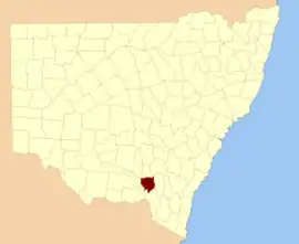
Wynyard County

Wynyard County is one of the 141 Cadastral divisions of New South Wales. It contains the city of Wagga Wagga. The Murrumbidgee River lies on the northern edge of the county, and the Tumut River on the eastern edge.

Wynyard
New South Wales
Location in New South Wales
Lands administrative divisions around Wynyard:
Bourke Clarendon Harden
Mitchell Wynyard Buccleuch
Goulburn Selwyn Selwyn
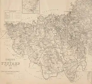
Map of Wynyard county from 1897 showing the parishes
The Murrumbidgee River at Gundagai; the boundary between Wynyard and Clarendon

Wynyard County was named in honour of Major-General Robert Henry Wynyard (1802-1864).[1]

Parishes within this county

A full list of parishes found within this county; their current LGA and mapping coordinates to the approximate centre of each location is as follows:

ParishLGACoordinates
AdelongSnowy Valleys Council35°18′54″S 148°02′04″E
BagoSnowy Valleys Council35°37′54″S 147°59′04″E
NangusCootamundra-Gundagai Regional Council35°08′54″S 147°58′04″E
BatlowSnowy Valleys Council35°27′54″S 148°10′04″E
BelmoreCity of Wagga Wagga35°28′54″S 147°53′04″E
BlanchCity of Wagga Wagga35°16′54″S 147°51′04″E
Book BookCity of Wagga Wagga35°21′54″S 147°30′04″E
BorambolaCity of Wagga Wagga35°09′54″S 147°38′04″E
BulalgeeGreater Hume Shire Council35°33′54″S 147°42′04″E
CalifatSnowy Valleys Council35°14′54″S 148°05′04″E
CarabostGreater Hume Shire Council35°36′54″S 147°41′04″E
CoreinbobCity of Wagga Wagga35°14′54″S 147°39′04″E
CourabyraSnowy Valleys Council35°39′54″S 148°01′04″E
CunningdrooCity of Wagga Wagga35°08′54″S 147°32′04″E
DutzonSnowy Valleys Council35°21′54″S 147°54′04″E
EllerslieSnowy Valleys Council35°14′54″S 147°56′04″E
EuaderaSnowy Valleys Council35°15′54″S 148°00′04″E
GadaraSnowy Valleys Council35°18′54″S 148°07′04″E
GilmoreSnowy Valleys Council35°22′54″S 148°09′04″E
GoldspinkSnowy Valleys Council35°37′54″S 147°55′04″E
GregadooCity of Wagga Wagga35°14′54″S 147°27′04″E
Gumly GumlyCity of Wagga Wagga35°09′54″S 147°28′04″E
HillasSnowy Valleys Council35°29′54″S 148°00′04″E
HindmarshSnowy Valleys Council35°27′54″S 148°06′04″E
HumulaCity of Wagga Wagga35°28′54″S 147°46′04″E
KeajuraCity of Wagga Wagga35°19′54″S 147°39′04″E
KilgowlaCity of Wagga Wagga35°23′54″S 147°38′04″E
KyeambaCity of Wagga Wagga35°23′54″S 147°29′04″E
LivingstoneCity of Wagga Wagga35°22′54″S 147°26′04″E
MateCity of Wagga Wagga35°26′54″S 147°51′04″E
MinjarySnowy Valleys Council35°15′54″S 148°10′04″E
MundarloCootamundra-Gundagai Regional Council35°06′54″S 147°51′04″E
MurraguldrieCity of Wagga Wagga35°27′54″S 147°36′04″E
Nacki NackiSnowy Valleys Council35°21′54″S 147°58′04″E
OberneCity of Wagga Wagga35°20′54″S 147°48′04″E
RowanCity of Wagga Wagga35°14′54″S 147°22′04″E
SelwynSnowy Valleys Council35°33′54″S 148°09′04″E
South GundagaiCootamundra-Gundagai Regional Council35°03′54″S 148°09′04″E
South Wagga WaggaCity of Wagga Wagga35°07′54″S 147°21′04″E
TarcuttaCootamundra-Gundagai Regional Council35°10′54″S 147°45′04″E
TarrabandraCootamundra-Gundagai Regional Council35°08′54″S 148°10′04″E
TumutSnowy Valleys Council35°16′54″S 148°10′04″E
TywongCity of Wagga Wagga35°14′54″S 147°33′04″E
UmbangoCity of Wagga Wagga35°26′54″S 147°46′04″E
UmutbeeCity of Wagga Wagga35°14′54″S 147°45′04″E
WallaceSnowy Valleys Council35°17′54″S 147°54′04″E
WerebolderaSnowy Valleys Council35°22′54″S 148°13′04″E
Willie PlomaCootamundra-Gundagai Regional Council35°08′54″S 148°03′04″E
WondalgaSnowy Valleys Council35°23′54″S 148°05′04″E
WoodGreater Hume Shire Council35°37′54″S 147°50′04″E
WoomahrigongCity of Wagga Wagga35°16′54″S 147°25′04″E
YabtreeWagga City Council35°06′54″S 147°45′04″E
YavenCootamundra-Gundagai Regional Council35°11′54″S 147°51′04″E

References

This article is issued from Wikipedia. The text is licensed under Creative Commons - Attribution - Sharealike. Additional terms may apply for the media files.