Carabost, New South Wales
Carabost is a foresting community in the south east part of the Riverina. It is situated about 16 kilometres north west of Rosewood and 22 kilometres south east of Kyeamba.
| Carabost New South Wales | |||||||||
|---|---|---|---|---|---|---|---|---|---|
 Carabost Hall, 2020 | |||||||||
Carabost | |||||||||
| Coordinates | 35°36′S 147°43′E | ||||||||
| Postcode(s) | 2650 | ||||||||
| Elevation | 551 m (1,808 ft) | ||||||||
| Location |
| ||||||||
| County | Wynyard | ||||||||
| State electorate(s) | Albury | ||||||||
| |||||||||
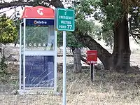
Carabost can be found on the Tumbarumba Road near the location of the Carabost National Forest - a large Pine Plantation in the area. The only facilities available in the area, other than the Carabost Town Hall built in 1927, and a Fire Brigade Shed, is a public telephone box and a post box - both at the same location as the district emergency gathering point which is used in the case of forest fire or similar emergency.
Carabost is the Gaelic form of Carbost on the Scottish island of Skye and means Copse farm.[2]
Carabost Post Office opened on 1 March 1879, and it closed on 4 March 1897. It then reopened on 1 January 1915 and was closed once again on 27 January 1968[3]
Climate
Located on the exposed western edge of the South West Slopes, Carabost experiences cool maximum temperatures relative to its altitude (particularly in winter), averaging just 9.1 °C (48.4 °F) in July.
| Climate data for Carabost Forest Headquarters (1938–1969); 580 m AMSL; 35° 40′ 01.02″ S | |||||||||||||
|---|---|---|---|---|---|---|---|---|---|---|---|---|---|
| Month | Jan | Feb | Mar | Apr | May | Jun | Jul | Aug | Sep | Oct | Nov | Dec | Year |
| Average high °C (°F) | 28.0 (82.4) |
27.2 (81.0) |
24.1 (75.4) |
18.7 (65.7) |
13.7 (56.7) |
10.8 (51.4) |
9.1 (48.4) |
10.8 (51.4) |
14.3 (57.7) |
18.0 (64.4) |
21.1 (70.0) |
25.4 (77.7) |
18.4 (65.2) |
| Average low °C (°F) | 11.0 (51.8) |
11.2 (52.2) |
9.0 (48.2) |
5.6 (42.1) |
3.2 (37.8) |
1.7 (35.1) |
0.2 (32.4) |
1.7 (35.1) |
3.2 (37.8) |
5.5 (41.9) |
7.0 (44.6) |
9.0 (48.2) |
5.7 (42.3) |
| Average precipitation mm (inches) | 56.4 (2.22) |
48.6 (1.91) |
61.2 (2.41) |
72.6 (2.86) |
96.4 (3.80) |
92.8 (3.65) |
112.5 (4.43) |
107.6 (4.24) |
84.4 (3.32) |
100.1 (3.94) |
70.5 (2.78) |
60.1 (2.37) |
963.2 (37.93) |
| Average precipitation days (≥ 0.2 mm) | 5.1 | 4.7 | 5.4 | 7.0 | 9.7 | 10.7 | 12.6 | 13.0 | 10.1 | 10.1 | 7.8 | 6.2 | 102.4 |
| Source: Australian Bureau of Meteorology; Carabost Forest Headquarters | |||||||||||||
Notes and references
- Travelmate Archived 24 March 2007 at the Wayback Machine
- Scottish Parliament, Place Names (PDF), archived from the original (PDF) on 17 March 2007, retrieved 30 June 2009
- Premier Postal History, Post Office List, retrieved 11 June 2009
External links
![]() Media related to Carabost, New South Wales at Wikimedia Commons
Media related to Carabost, New South Wales at Wikimedia Commons