Wyoming Highway 24
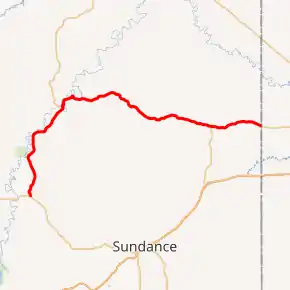
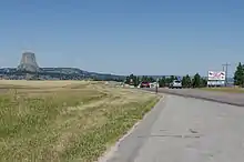
Wyoming Highway 24 (WYO 24) is a 46.72-mile-long (75.19 km) Wyoming state highway known as the Bear Lodge Highway. The route passes through the northern portion of the Bear Lodge Mountains, part of the Black Hills National Forest. Highway 24 spans from U.S. Route 14 to the South Dakota state line, where it continues south as South Dakota Highway 34. The highway passes by Devils Tower National Monument.
| |||||||
|---|---|---|---|---|---|---|---|
| Bear Lodge Highway | |||||||
WYO 24 highlighted in red | |||||||
| Route information | |||||||
| Maintained by WYDOT | |||||||
| Length | 46.72 mi[1] (75.19 km) | ||||||
| Existed | 1961[1]–present | ||||||
| Major junctions | |||||||
| West end | |||||||
| East end | |||||||
| Location | |||||||
| Counties | Crook | ||||||
| Highway system | |||||||
State highways in Wyoming
| |||||||

Route description
WYO 24 is spawned from US 14 at Carlile Junction (also known as Devils Tower Junction). From there, it travels in a north–south direction, although the route is signed east–west. It is mainly a two-lane highway from US 14 to near Devils Tower National Monument. When it gets to Devils Tower, it spawns a short spur, Wyoming Highway 110. After passing by WYO 110, it then curves northeast-southwest. The road reaches Hulett, where it intersects Wyoming Highway 112. In Hulett, WYO 24 is dubbed Main Street and A Street. Moving on, WYO 24 curves to the signed east–west orientation, but curves northwest-southeast. WYO 24 passes by some gulches, most notably Reservoir Gulch and Lucky Gulch. WYO 24 then turns south, then generally follows the east–west orientation. It then intersects Wyoming Highway 111 a short time later. There are no further major junctions and towns on the route, as WYO 24 crosses the state line and becomes South Dakota Highway 34.
History
Wyoming Highway 24 was not in the original State Highway grid until 1961. The predecessor to this route was Wyoming Highway 514.[1]
Major intersections
The entire route is in Crook County. [2]
| Location[2] | mi[3] | km | Destinations | Notes | |
|---|---|---|---|---|---|
| | 0.0 | 0.0 | |||
| | 6.0 | 9.7 | Eastern terminus of WYO 110 | ||
| Hulett | 15.1 | 24.3 | Southern terminus of WYO 112 | ||
| | 39.1 | 62.9 | Northern terminus of WYO 111 | ||
| | 46.2 | 74.4 | Continuation beyond South Dakota state line | ||
| 1.000 mi = 1.609 km; 1.000 km = 0.621 mi | |||||
See also
 U.S. Roads portal
References
- Wyoming Routes 000-099
- Geography Division (2016). "Wyoming Governmental Unit Reference Map". United States Census Bureau. Retrieved January 24, 2017.
- Google (February 15, 2014). "WYO 24" (Map). Google Maps. Google. Retrieved February 15, 2014.
External links
| Wikimedia Commons has media related to Wyoming Highway 24. |
