Yambio Airport
Yambio Airport is an airport serving Yambio in South Sudan.
Yambio Airport | |||||||||||
|---|---|---|---|---|---|---|---|---|---|---|---|
| Summary | |||||||||||
| Airport type | Public, Civilian | ||||||||||
| Owner | Civil Aviation Authority of South Sudan | ||||||||||
| Serves | Yambio, South Sudan | ||||||||||
| Location | Yambio, | ||||||||||
| Elevation AMSL | 2,375 ft / 724 m | ||||||||||
| Coordinates | 04°34′12″N 28°25′32″E | ||||||||||
| Map | |||||||||||
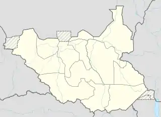 Yambio Location of Yambio Airport in South Sudan | |||||||||||
| Runways | |||||||||||
| |||||||||||
Location
Yambio Airport (IATA: n/a, ICAO: HSYA) is located in Yambio County in Gbudwe, in the town of Yambio, in the southwestern part of South Sudan, near the International borders with the Democratic Republic of the Congo and the Central African Republic. The airport is located just outside town to the northeast of the central business district.
This location lies approximately 355 kilometres (221 mi), by air, west of Juba International Airport, the largest airport in South Sudan.[1] The geographic coordinates of this airport are: 4° 34' 12.00"N, 28° 25' 320.02"E (Latitude: 4.57000; Longitude: 28.42556). Yambio Airport sits at an elevation of 724 metres (2,375 ft) above sea level.[2] The airport has a single unpaved runway, measuring approximately 1,000 metres (3,300 ft) in length.
Overview
Yambio Airport is a small civilian that serves the town of Yambio and surrounding communities. The airport does not yet receive regular scheduled airline service, though chartered airlines fly to and from the airport.
References
- "Distance between Yambio (Gharb al Istiwa'iyah) and Juba () (Airport) (Sudan)". distancecalculator.globefeed.com. Retrieved 2018-08-26.
- "HSYA pilot info @ OurAirports". www.ourairports.com. Retrieved 2018-08-26.
