Yuleba
Yuleba (/ˈjuːləbə/ YOO-lə-bə) is a rural town and locality in the Maranoa Region, in the south-west of Queensland, Australia.[2][3] In the 2016 census, Yuleba had a population of 207 people.[1]
| Yuleba Queensland | |||||||||||||||
|---|---|---|---|---|---|---|---|---|---|---|---|---|---|---|---|
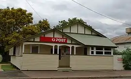 Post office at Yuleba | |||||||||||||||
 Yuleba | |||||||||||||||
| Coordinates | 26.6130°S 149.3825°E | ||||||||||||||
| Population | 207 (2016 census)[1] | ||||||||||||||
| • Density | 2.360/km2 (6.113/sq mi) | ||||||||||||||
| Established | 1865 | ||||||||||||||
| Postcode(s) | 4427 | ||||||||||||||
| Area | 87.7 km2 (33.9 sq mi) | ||||||||||||||
| Time zone | AEST (UTC+10:00) | ||||||||||||||
| Location | |||||||||||||||
| LGA(s) | Maranoa Region | ||||||||||||||
| State electorate(s) | Warrego | ||||||||||||||
| Federal Division(s) | Maranoa | ||||||||||||||
| |||||||||||||||
Geography
Yuleba is located 294 kilometres (183 mi) west of Toowoomba, 82 kilometres (51 mi) west of Miles, 420 kilometres (260 mi) west of the state capital, Brisbane along the Warrego Highway.
History
Mandandanji (also known as Mandandanyi, Mandandanjdji, Kogai) is an Australian Aboriginal language spoken by the Mandandanji people. The Mandandanji language region includes the landscape within the local government boundaries of the Maranoa Regional Council, particularly Roma, Yuleba and Surat, then east towards Chinchilla and south-west towards Mitchell and St George.[4]
The town is said to be named after an Aboriginal word meaning "the place of water lilies".[5] When it was named in 1865, it was a settlement on Yuleba Creek. However, in October 1879 the town moved to the railway crossing on Yuleba Creek and was officially called Baltinglass. However, this was changed to Yuleba in 1901. However, due to an error in assembling a sign for the railway station, the station and the town were known as the misspelt Yeulba. In 1938, the name was changed to the original intended name of Yuleba.[2][6][7]
Baltinglass Provisional School opened on 10 November 1880. On 1 April 1884 it was renamed Yeulba State School. In 1939 the spelling of the name was changed to Yuleba State School.[8][9]
As a railhead for the region to the west, the town was an important centre until the railway was extended again to Roma in 1910.[5]
The last Cobb and Co stagecoach run, on 16 August 1924, ran between Yuleba and Surat.[10]
In 1954 the Bendemeer Shire Council erected a memorial hall in Yuleba with an honour board commemorating those from the shire who had served in World War II. It was officially opened on 15 May 1954 by Alfred Dohring, the Member of the Queensland Legislative Assembly for Roma.[11]
On 9 October 1964 Queensland Premier Frank Nicklin unveiled a large mural at the Yuleba Memorial Hall. The mural depicts many scene of wars and was painted by local artist and jackaroo Robert (Fred) Doyle.[12]
At the 2006 census, Yuleba had a population of 183.[13]
The Yuleba Public Library had a major refurbishment in 2015.[14]
Education
Yuleba State School is a government primary (Prep-6) school for boys and girls at Perry Street (26.6145°S 149.3819°E).[15][16] In 2018, the school had an enrolment of 23 students with 2 teachers and 5 non-teaching staff (2 full-time equivalent).[17]
There is no secondary school in Yuleba. the closest Secondary School is Wallumbilla State School but it only offers high school education up to Year 10. The nearest state high schools offering Years 11 and 12 of secondary school are Roma State College in Roma (61 km west) and Miles State High School in Miles (81 km east)
Economy
Today, Yuleba is the site of a modern mining and processing facility working a high grade silica deposit.[18]
Amenities
The Maranoa Regional Council operates a public library in Yuleba at Stephenson Street.[19]
References
- Australian Bureau of Statistics (27 June 2017). "Yuleba (SSC)". 2016 Census QuickStats. Retrieved 20 October 2018.

- "Yuleba – town in Maranoa Region (entry 38786)". Queensland Place Names. Queensland Government. Retrieved 2 November 2019.
- "Yuleba – locality in Maranoa Region (entry 47472)". Queensland Place Names. Queensland Government. Retrieved 2 November 2019.
- "Mandandanji". State Library of Queensland. 15 January 2020.
- "Yuleba". Travel. Sydney Morning Herald. 8 February 2004. Retrieved 28 May 2007.
- "Yeulba Should Be Yuleba". The Courier-mail (1520). Queensland, Australia. 16 July 1938. p. 2. Retrieved 16 August 2016 – via National Library of Australia.
- "About the Shire". Shire of Bendemere. Retrieved 27 May 2007.
- Queensland Family History Society (2010), Queensland schools past and present (Version 1.01 ed.), Queensland Family History Society, ISBN 978-1-921171-26-0
- "Agency ID 5872, Yuleba State School". Queensland State Archives. Retrieved 17 December 2020.
- "Yuleba". Western Downs - Places to visit. Tourism Queensland. Retrieved 28 May 2007.
- "Yuleba Memorial Hall". Monument Australia. Retrieved 20 September 2020.
- "Yuleba Honour Board". Queensland War Memorials Register. 23 June 2014. Retrieved 20 September 2020.
- Australian Bureau of Statistics (25 October 2007). "Yuleba (Bendemere Shire) (State Suburb)". 2006 Census QuickStats. Retrieved 25 June 2011.
- "Public Libraries Statistical Bulletin 2016-17" (PDF). Public Libraries Connect. November 2017. Retrieved 29 January 2018.
- "State and non-state school details". Queensland Government. 9 July 2018. Archived from the original on 21 November 2018. Retrieved 21 November 2018.
- "Yuleba State School". Retrieved 21 November 2018.
- "ACARA School Profile 2018". Australian Curriculum, Assessment and Reporting Authority. Retrieved 28 January 2020.
- "About us". Yuleba Minerals Pty Ltd. Retrieved 28 May 2007.
- "Yuleba Library". Public Libraries Connect. 25 July 2017. Retrieved 29 January 2018.
