Zinder Region
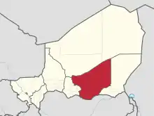
Zinder Region is one of the seven regions of Niger; the capital of the region is Zinder. The region covers 145,430 km². It is most populous province of Niger.
Zinder | |
|---|---|
 Location within Niger | |
| Coordinates: 13°42′N 9°12′E | |
| Country | |
| Capital | Zinder |
| Area | |
| • Total | 145,430 km2 (56,150 sq mi) |
| Population (2012[1]) | |
| • Total | 3,539,764 |
| • Density | 24/km2 (63/sq mi) |
| Time zone | UTC+1 (West Africa Time) |
| HDI (2017) | 0.321[2] low |
History
Numerous Palaeolithic and Neolithic remains, as well as cave paintings, have been found in the Termit Massif.[3]
Zinder was the centre of the Sultanate of Damagaram, a powerful sultanate which dominated much of the surrounding region from the mid-18th century until the French conquest in the 1890s.[4] Zinder was initially the capital of the Niger territory, however this was moved to Niamey in 1926 and thereafter Zinder declined in importance, though it remains an important regional centre.[3]
Geography
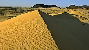
Zinder Region is located in the southeast of Niger and covers 145,430 km². It borders Agadez Region to the north, Diffa Region to the east, Nigeria to the south (specifically, the states of Yobe, Jigawa and Katsina), and Maradi Region to the west. The landscape is primarily Sahelian in the south, merging into the Sahara desert in the north of the region. The terrain is predominantly flat, except for the Koutous Hills, which lie north of Kelle, and the Termit Massif in the far north of the region.[3]
Settlements
Zinder is the regional capital; other major settlements include Alakoss, Albarkaram, Bande, Boune, Dakoussa, Dan-Barto, Dantchiao, Daouche, Dogo-Dogo, Falenko, Gaffati, Gamou, Garagoumsa, Gouchi, Gouna, Goure, Guidiguir, Hamdara, Ichirnawa, Kantche, Kelle, Kolleram, Kourni, Kwaya, Magaria, Malawa, Matameye, Mirriah, Moa, Ollelewa, Sassoumbroum, Tanout, Tenhya, Tesker, Tsaouni, Yaouri and Yekoua.[5]
Administrative subdivisions
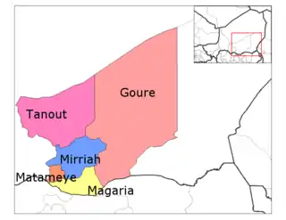
Zinder was divided into 5 Departments:
Of the 27 administrative stations (postes administratifs) of Niger which were set out in a law dated 1 August 2011 to become departments and for which the appointment of prefects on 29 February 2012 completed the conversion, the following 5 are in Zinder region.[6]
- Belbédji Department
- Damagaram Takaya Department
- Dungass Department
- Takiéta Department
- Tesker Department
So, Zinder now has 10 departments.[7]
Demographics
As of 2012 the population of the Region was 3,539,764.[8] The main ethnolinguistic groups are various Arab groups, Fulani, Hausa, Kanuri, Dazaga Toubou and Tuareg groups such as the Tayart Tamajeq.[9] The Tagdal language, thought to be a mixed Songhay-Tuareg language, is also spoken.[10]
| Year | Pop. | ±% |
|---|---|---|
| 1977 | 1,002,222 | — |
| 1985 | 1,411,061 | +40.8% |
| 2001 | 2,080,250 | +47.4% |
| 2012 | 3,539,764 | +70.2% |
| source:[11] | ||
References
- Annuaire statistique du Niger
- "Sub-national HDI - Area Database - Global Data Lab". hdi.globaldatalab.org. Retrieved 2018-09-13.
- Geels, Jolijn, (2006) Bradt Travel Guide - Niger, pgs. 213-26
- Abdourahmane Idrissa & Samuel Decalo, "Damagaram, Sultanate of", in Historical Dictionary of Niger, pp. 160-161
- "Carte de référence: Niger - Région de Zinder (1 février 2019)" (PDF). REACH Initiative. Retrieved 28 October 2019.
- "Departments of Niger". Statoids. Retrieved 21 August 2020.
- "Niger Zinder Region - Departments". City Population. Retrieved 21 August 2020.
- Annuaire statistique du Niger
- "Languages of Niger". Ethnologue. Retrieved 24 October 2019.
- "Languages of Niger". Ethnologue. Retrieved 24 October 2019.
- Niger: Administrative Division population statistics
- Ouverture, hier, de l'Institut Universitaire de Technologie (I.U.T) de Zinder : Un nouveau tournant dans le secteur de l'enseignement Supérieur au Niger. Abdou Saïdou, ONEP Zinder-Diffa. 29 Octobre 2008.
- "Archived copy". Archived from the original on 2016-10-12. Retrieved 2016-05-21.CS1 maint: archived copy as title (link)
External links
| Wikimedia Commons has media related to Zinder Region. |
![]() Zinder travel guide from Wikivoyage
Zinder travel guide from Wikivoyage