Regions of Niger
Niger is divided into seven regions (French: régions; singular – région), each named after its capital.
 |
|---|
| This article is part of a series on the politics and government of Niger |
| Judiciary |
Current regions
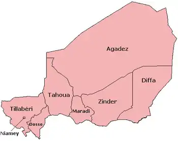
| Region | Area (km2)[1] |
Population (2012 census) |
|---|---|---|
| Agadez | 667,799 | 487,620 |
| Diffa | 156,906 | 593,821 |
| Dosso | 33,844 | 2,037,713 |
| Maradi | 41,796 | 3,402,094 |
| Niamey | 402 | 1,026,848 |
| Tahoua | 113,371 | 3,328,365 |
| Tillabéri | 97,251 | 2,722,842 |
| Zinder | 155,778 | 3,539,764 |
- Additionally, the national capital, Niamey, comprises a capital district.
Current administrative structure
The Regions are subdivided into departments and communes. As of 2005, there were 36 départements, divided into 265 communes, 122 cantons and 81 groupements. The latter two categories cover all areas not covered by urban communes (population over 10000) or rural communes (total population 13 million), and are governed by the department, whereas communes have had elected councils and mayors since 1999. Additional semi-autonomous subdivisions include sultanates, provinces and tributaries (tribus).[2] The Nigerien government estimates there are an additional 17000 villages administered by rural communes, while there are a number of quartiers (boroughs or neighborhoods) administered by urban communes.[3]
Restructuring
Prior to the devolution program on 1999-2006, the regions were styled as departments. The current departments used to be called arrondissements.[4]
Historical evolution
Prior to independence, Niger was divided into sixteen cercles as second-level administrative divisions: Agadez, Birni N'Konni, Dogondoutchi, Dosso, Filingué, Gouré, Madaoua, Magaria, Maradi, N'Guigmi, Niamey, Tahoua, Téra, Tessaoua, Tillabéry, and Zinder. Their capitals had the same names as the cercle.
After independence, the 31 December 1961 Law of territorial organization created 31 circonscriptions. The 16 colonial cercles continued to exist, and served as a level of division above these circonscriptions. Four cercles (Dogondoutchi, Filingué, N'Guigmi, and Téra) had only one circonscription. The Law of August 14, 1964 then reorganized the country into seven departments, adopting the French second-level administration naming system, in contrast to neighbor Mali, which retained the colonial cercles and regions.
See also
- Departments of Niger
- Communes of Niger
- Geography of Niger
- ISO 3166-2:NE for the region codes under the ISO 3166-2 standard.
- List of FIPS region codes (M-O) for the department codes under the FIPS 10-4 standard.
References
- Niger at GeoHive Archived 2015-04-20 at the Wayback Machine
- Loi 2001-23, Article 6
- GOUVERNEMENT DE LA RÉPUBLIQUE DU NIGER. APPUI À LA MISE EN ŒUVRE DU NEPAD–PDDAA, TCP/NER/2908 (I) (NEPAD Ref. 05/24 F), Volume IV de VI : PROFIL DE PROJET D’INVESTISSEMENT BANCABLE, Programme national de développement des infrastructures rurales (PNDIR) Government of the Republic of Niger, 24 April 2005, hosted bt the FAO.
-
- Mbaye Mbengue FAYE, Faria Ibrahim GESTION DES DECHETS ISSUS DES SOINS DE SANTE (DISS):RAPPORT PROVISOIRE, World Bank, Niamey, Décembre 2001.
- FONDS AFRICAIN DE DEVELOPPEMENT: ETUDE DE MOBILISATION DES EAUX DANS LA REGION DE MARADI NIGER. DEPARTEMENT AGRICULTURE ET DEVELOPPEMENT RURAL, OCAR. African Development Bank Group, MARCH 2003
- [http://www.ucdp.uu.se/gpdatabase/peace/nig19950415.pdf ACCORD ÉTABLISSANT UNE PAIX DÉFINITIVE ENTRE LE GOUVERNEMENT DE LA RÉPUBLIQUE DU NIGER ET L?ORGANISATION DE LA RÉSISTANCE ARMÉE (O. R. A.)
- According to Statoids Archived 2009-07-24 at the Wayback Machine: "~1992: Tillabéry Region/department split from Niamey (whose FIPS code was NG05 before the change). Status of Niamey changed from department to capital district."