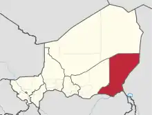
Diffa Region
Diffa is one of the seven Regions of Niger, located in the southeast of the country. The capital of the region is Diffa.
Diffa | |
|---|---|
 Location within Niger | |
| Coordinates: 14°N 13°E | |
| Country | |
| Capital | Diffa |
| Area | |
| • Total | 156,906 km2 (60,582 sq mi) |
| Population (2012[1]) | |
| • Total | 593,821 |
| • Density | 3.8/km2 (9.8/sq mi) |
| Time zone | UTC+1 (West Africa Time) |
| HDI (2017) | 0.336[2] low |
Geography
Diffa Region is situated in the extreme southeast of Niger between 10° 30’ and 15° 35’ longitude East and 13° 04’ and 18° 00’ latitude North. It covers 156 906 km², and it borders Agadez Region to the north, Chad to the east, Nigeria to the south, and Zinder Region to the west. The landscape is primarily Sahelian in the south, merging into the Sahara desert in the north of the region. In the far southeast can be found Niger's portion of Lake Chad; formerly extending as far west as N'guigmi, the lake has shrunk drastically in recent decades.[3] In the southeast the Komadougou Yobe river forms part of the border with Nigeria.[3]
Settlements
Diffa is the regional capital; other major settlements include Bosso, Chetimari, Dungass, Gueskerou, Goudoumaria, Kablewa, Mainé-Soroa, N'Gourti, N'Guelbély, N'guigmi and Toumour.[4]
Administrative subdivisions
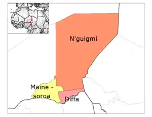
Diffa Region is divided into three Departments:
The Region also includes three Urban Communes, a number of Rural Communes, four Cantons, and over twenty Groupments (administrative councils of nomadic communities). The Urban Communes are Diffa, Maïné-Soroa, N'guigmi; while the Rural Communes include Bosso, Chétimari, Goudoumaria, N'gourti, Kabléwa, Nguel beyli, and Gueskérou.
Demographics
The population was estimated in 2000 at 216,245 and 346,595 inhabitants in the 2001 census; as of 2011 the population stood at 489,531.[5] The population is 85% sedentary and 15% nomadic, practising seasonal migration with their livestock. The age range is 37% aged less than 20, 57% between 20 – 60, and 6% older than 60 years old. The total annual growth rate is around 1.2% and it is one of the least populated areas of Niger ( 2.2 people/km²). The main ethnolinguistic groups in the region are the Diffa Arabs, Fula, Hausa, Kanuri, Dazaga and Tedaga Toubou and Tuaregs.[6][7]
| Year | Pop. | ±% |
|---|---|---|
| 1977 | 167,382 | — |
| 1985 | 189,091 | +13.0% |
| 2001 | 346,595 | +83.3% |
| 2012 | 593,821 | +71.3% |
| source:[8] | ||
Refugees
Refugees from Nigeria fleeing violence from Boko Haram are living with local populations in the Diffa Region. As of 11 June 11 2014, the International Rescue Committee (IRC) estimated that as many as 1,000 refugees a week were crossing the border into Diffa region; four out of five are women and girls.[9] By October 2015 the number of Nigerian refugees in the region had risen to at least 150,000.[10] After a lull in the fighting in 2017-18, violence increased in 2019, further worsening an already fragile security situation.[11]
Economy
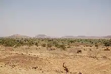
The economy of Diffa Region is primarily agricultural, based upon pastoralism and farming. The major crop, grown both for subsistence and sale, is millet, especially drought-tolerant varieties. One third of arable land is devoted to farming: almost 105,000 hectares farmed of the 299,500 hectares of arable land. Areas of the east and south also grow rice and maize. Irrigation in the valleys around Maïné-Soroa make this possible, as does the edge of Lake Chad (3,000 km² in the far east) and the seasonal Komadougou Yobe river valley in the south, which forms around 150 km of the border with Nigeria. Despite this the Diffa Region is among the most unproductive agricultural areas in Niger, and all of West Africa, making it especially vulnerable to drought and famine.
References
- Annuaire statistique du Niger
- "Sub-national HDI - Area Database - Global Data Lab". hdi.globaldatalab.org. Retrieved 2018-09-13.
- Geels, Jolijn, (2006) Bradt Travel Guide - Niger, pgs. 227-38
- "Carte de référence: Niger - Région de Diffa (30 janvier 2019)" (PDF). REACH Initiative. Retrieved 24 October 2019.
- Annuaire statistique du Niger
- Présentation de la région de Diffa: des potentialités naturelles considérables. Abdou Saïdou, Le Sahel (Niamey). 17 December 2009
- "Languages of Niger". Ethnologue. Retrieved 24 October 2019.
- Niger: Administrative Division population statistics
- Damon, Arwa (2014-06-11). "Where are Nigeria's missing girls? On the hunt for Boko Haram". CNN.com. Retrieved 2014-06-12.
- "Boko Haram fighters kill two Niger soldiers, wound four in ambush". Reuters. 2 October 2015. Retrieved 8 October 2015.
- "ACAPS Briefing Note: Niger - Displacement in Diffa region (5 April 2019)". Relief Web. 5 April 2019. Retrieved 24 October 2019.
- Portions of this article were translated from the French language Wikipedia article fr:Diffa (région), 2008-06-19.
- Decalo, Samuel (1997). Historical Dictionary of the Niger (3rd ed.). Boston & Folkestone: Scarecrow Press. ISBN 0-8108-3136-8.:p. 120
- Geels, Jolijn (2006). Niger. Chalfont St Peter, Bucks / Guilford, Connecticut: Bradt UK / Globe Pequot Press. ISBN 978-1-84162-152-4.:pp.227–238
- The Wodaabe Of Southeastern Niger. In Nikolaus Schareika. Ecological Knowledge And Herd Movement Strategies Among The Wodaabe Of Southeastern Niger. Institut für Ethnologie und Afrikastudien, Johannes Gutenberg-Universität Mainz/The Food and Agriculture Organization of the United Nations (2003) ISBN 92-5-105061-9