Łosice County
Łosice County (Polish: powiat łosicki) is a unit of territorial administration and local government (powiat) in Masovian Voivodeship, east-central Poland. It came into being on January 1, 1999, as a result of the Polish local government reforms passed in 1998. Its administrative seat and only town is Łosice, which lies 118 kilometres (73 mi) east of Warsaw.
Łosice County
Powiat łosicki | |
|---|---|
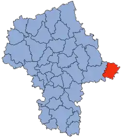 Location within the voivodeship | |
 Division into gminas | |
| Coordinates (Łosice): 52°13′N 22°43′E | |
| Country | |
| Voivodeship | Masovian |
| Seat | Łosice |
| Gminas | |
| Area | |
| • Total | 771.77 km2 (297.98 sq mi) |
| Population (2019) | |
| • Total | 30,895 |
| • Density | 40/km2 (100/sq mi) |
| • Urban | 7,049 |
| • Rural | 23,846 |
| Car plates | WLS |
| Website | http://www.losice.pl |
The county covers an area of 771.77 square kilometres (298.0 sq mi). As of 2019, its total population is 30,395, out of which the population of Łosice is 7,049 and the rural population is 23,846.[1]
Neighbouring counties
Łosice County is bordered by Siemiatycze County to the north, Biała Podlaska County to the south-east and Siedlce County to the west.
Administrative division
The county is subdivided into six gminas (one urban-rural and five rural). These are listed in the following table, in descending order of population.
| Gmina | Type | Area (km2) |
Population (2019) |
Seat |
| Gmina Łosice | urban-rural | 121.2 | 10,815 | Łosice |
| Gmina Sarnaki | rural | 197.3 | 4,673 | Sarnaki |
| Gmina Platerów | rural | 129.0 | 4,851 | Platerów |
| Gmina Stara Kornica | rural | 119.3 | 4,781 | Stara Kornica |
| Gmina Olszanka | rural | 87.3 | 2,961 | Olszanka |
| Gmina Huszlew | rural | 117.6 | 2,814 | Huszlew |
References
- GUS. "Population. Size and structure and vital statistics in Poland by territorial divison in 2019. As of 30th June". stat.gov.pl. Retrieved 2020-09-14.