Gostynin County
Gostynin County (Polish: powiat gostyniński) is a unit of territorial administration and local government (powiat) in Masovian Voivodeship, east-central Poland. It came into being on January 1, 1999, as a result of the Polish local government reforms passed in 1998. Its administrative seat and only town is Gostynin, which lies 107 kilometres (66 mi) west of Warsaw.
Gostynin County
Powiat gostyniński | |
|---|---|
 Flag  Coat of arms | |
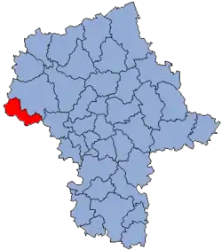 Location within the voivodeship | |
 Division into gminas | |
| Coordinates (Gostynin): 52°25′N 19°28′E | |
| Country | |
| Voivodeship | Masovian |
| Seat | Gostynin |
| Gminas | Total 5 (incl. 1 urban)
|
| Area | |
| • Total | 615.56 km2 (237.67 sq mi) |
| Population (2019) | |
| • Total | 43,099 |
| • Density | 70/km2 (180/sq mi) |
| • Urban | 18,588 |
| • Rural | 24,511 |
| Car plates | WGS |
| Website | http://gostynin.powiat.pl/ |
The county covers an area of 615.56 square kilometres (237.7 sq mi). As of 2019 its total population is 43,099, out of which the population of Gostynin is 18,588, and the rural population is 24,511.[1]
Neighbouring counties
Gostynin County is bordered by Płock County to the north-east, Sochaczew County to the east, Łowicz County to the south-east, Kutno County to the south and Włocławek County to the north-west.
Administrative division
The county is subdivided into five gminas (one urban and four rural). These are listed in the following table, in descending order of population.
| Gmina | Type | Area (km²) |
Population (2019) |
Seat |
| Gostynin | urban | 32.3 | 18,588 | |
| Gmina Gostynin | rural | 270.7 | 12,066 | Gostynin * |
| Gmina Szczawin Kościelny | rural | 127.1 | 4,866 | Szczawin Kościelny |
| Gmina Sanniki | rural | 94.6 | 4,056 | Sanniki |
| Gmina Pacyna | rural | 90.9 | 3,523 | Pacyna |
| * seat not part of the gmina | ||||
References
- GUS. "Population. Size and structure and vital statistics in Poland by territorial divison in 2019. As of 30th June". stat.gov.pl. Retrieved 2020-09-14.
Seat: Gostynin (urban gmina) | ||
| Rural gminas | | |