Pruszków County
Pruszków County (Polish: powiat pruszkowski) is a unit of territorial administration and local government (powiat) in Masovian Voivodeship, east-central Poland. It came into being on January 1, 1999, as a result of the Polish local government reforms passed in 1998. Its administrative seat and largest town is Pruszków, which lies 15 kilometres (9 mi) west of Warsaw. The county also contains the towns of Piastów, lying 4 km (2 mi) north-east of Pruszków, and Brwinów, 7 km (4 mi) south-west of Pruszków.
Pruszków County
Powiat pruszkowski | |
|---|---|
 Flag  Coat of arms | |
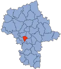 Location within the voivodeship | |
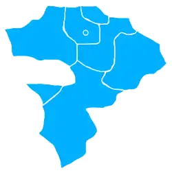 Division into gminas | |
| Coordinates (Pruszków): 52°10′N 20°48′E | |
| Country | |
| Voivodeship | Masovian |
| Seat | Pruszków |
| Gminas | Total 6 (incl. 2 urban)
|
| Area | |
| • Total | 246.31 km2 (95.10 sq mi) |
| Population (2019) | |
| • Total | 165,039 |
| • Density | 670/km2 (1,700/sq mi) |
| • Urban | 98,296 |
| • Rural | 66,743 |
| Car plates | WPR |
| Website | http://www.powiat.pruszkow.pl |
The county covers an area of 246.31 square kilometres (95.1 sq mi). As of 2019 its total population is 165,039, out of which the population of Pruszków is 62,076, that of Piastów is 22,619, that of Brwinów is 13,601, and the rural population is 66,743.[1]
Neighbouring counties
Pruszków County is bordered by Warsaw West County to the north, the city of Warsaw to the east, Piaseczno County to the south-east and Grodzisk Mazowiecki County to the west.
Administrative division
The county is subdivided into six gminas (two urban, one urban-rural and three rural). These are listed in the following table, in descending order of population.
| Gmina | Type | Area (km²) |
Population (2019) |
Seat |
| Pruszków | urban | 19.2 | 62,076 | |
| Gmina Brwinów | urban-rural | 69.2 | 26,543 | Brwinów |
| Piastów | urban | 5.8 | 22,619 | |
| Gmina Raszyn | rural | 43.9 | 21,776 | Raszyn |
| Gmina Michałowice | rural | 34.9 | 18,209 | Michałowice |
| Gmina Nadarzyn | rural | 73.4 | 13,816 | Nadarzyn |
References
- GUS. "Population. Size and structure and vital statistics in Poland by territorial divison in 2019. As of 30th June". stat.gov.pl. Retrieved 2020-09-14.
| Urban gminas | | |
|---|---|---|
| Urban-rural gmina | ||
| Rural gminas | ||