2005 Azores subtropical storm
The 2005 Azores subtropical storm was the 19th nameable storm and only subtropical storm of the extremely active 2005 Atlantic hurricane season. It was not officially named by the US National Hurricane Center as it was operationally classified as a non-tropical low. The storm developed in the eastern Atlantic Ocean out of a low-pressure area that gained subtropical characteristics on October 4. The storm was short-lived, crossing over the Azores later on October 4 before becoming extratropical again on October 5. No damages or fatalities were reported during that time. After being absorbed into a cold front, the system went on to become Hurricane Vince, which affected the Iberian Peninsula.
| Subtropical storm (SSHWS/NWS) | |
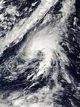
 The storm at peak intensity near the Azores on October 4 | |
| Formed | October 4, 2005 |
|---|---|
| Dissipated | October 5, 2005 |
| Highest winds | 1-minute sustained: 50 mph (85 km/h) |
| Lowest pressure | 997 mbar (hPa); 29.44 inHg |
| Fatalities | None reported |
| Areas affected | Azores |
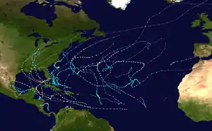
| Part of the 2005 Atlantic hurricane season | |
Months after the hurricane season, when the National Hurricane Center was performing its annual review of the season and its named storms, forecasters Jack Beven and Eric Blake identified this previously unnoticed subtropical storm. Despite its unusual location and wide wind field, the system had a well-defined centre convecting around a warm core.
Meteorological history

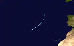
The system originated out of an upper-level low just west of the Canary Islands on September 28. The low organized itself over the next days, producing several bursts of convection. While remaining non-tropical with a cold core it moved gradually west to northwest. On October 3, it became a broad surface low about 400 nautical miles (460 mi, 740 km) southwest of São Miguel Island in the Azores.[1] Early on October 4, convection increased as the surface low organized itself, and the system became a subtropical depression.[2]
Around the same time, the depression turned northeast into a warm sector ahead of an oncoming cold front, and strengthened into a subtropical storm. The system continued to track northeast and strengthened slightly, reaching its peak intensity of 50 mph (85 km/h) as it approached the Azores that evening. After tracking through the Azores, the storm weakened slightly as it moved to the north-northeast. Through an interaction with the cold front early on October 5 the subtropical storm became extratropical. The system was fully absorbed by the front later that day.[2] The newly absorbed system would separate from the dissolving frontal system and become Subtropical Storm Vince on October 8.[3]
At the time, the system was not believed to have been subtropical. However, there were several post-season findings that confirmed that the system was indeed a subtropical storm. The first was the cloud pattern, in which it had deep convection around the center and was better organized with a well-defined center of circulation. In addition, the system had a warm core more typical of tropical cyclones as opposed to the cold core of extratropical cyclones. The warm-core nature also meant that there were no warm or cold fronts attached to the system, as temperatures did not change ahead of and behind the system,[4] until an unrelated cold front passed the Azores.[5] Satellite imagery suggested that the system was briefly a tropical storm as the warm core was found; however, the widespread wind field and the presence of an upper-level trough confirmed that it was only subtropical.[2]
Impact, classification and records
Tropical storm-force winds were reported across parts of the Azores, primarily on the eastern islands. The strongest winds were reported on Santa Maria Island, where 10-minute sustained winds reached 49 mph (79 km/h) with gusts to 59 mph (94 km/h).[6] Ponta Delgada faced 38 mph (61 km/h) winds, with the peak recorded gust being 52 mph (85 km/h).[1] No damage or fatalities were reported.[2]
The 2005 Azores storm was not classified as a subtropical storm until April 2006, after a reassessment by the National Hurricane Center.[7] Had it been operationally classified as such, it would have been named Tammy.[8] Every year, the NHC re-analyzes the systems of the past hurricane season and revises the storm history if there is new data that was operationally unavailable.[2] This reanalysis revealed that the storm became a subtropical storm on October 4, making it the earliest forming 19th Atlantic tropical or subtropical storm on record.[9][10] The previous record holder was an unnamed 1933 tropical storm that developed on October 26.[9] The record is now held by Hurricane Teddy, which attained tropical storm strength on September 14, 2020.[11][12]
References
- Beven II, John L.; Lixion A. Avila; Eric S. Blake; Daniel P. Brown; James L. Franklin; Richard D. Knabb; Richard J. Pasch; Famie R. Rhome & Stacy R. Stewart (March 2008). "Annual Summary: Atlantic Hurricane Season of 2005" (PDF). Monthly Weather Review. 136 (3): 1131–1141. Bibcode:2008MWRv..136.1109B. doi:10.1175/2007MWR2074.1. Archived from the original (PDF) on 10 September 2008. Retrieved 2008-09-08.
- National Hurricane Center (2006-04-10). "Tropical Cyclone Report: Unnamed Subtropical Storm" (PDF). National Oceanic and Atmospheric Administration. Retrieved 2006-10-31.
- National Hurricane Center (2006-02-22). "Tropical Cyclone Report: Hurricane Vince" (PDF). National Oceanic and Atmospheric Administration. Archived (PDF) from the original on 24 May 2006. Retrieved 2006-05-04.
- Computer Generated (2005-10-08). "History for Santa Maria, Azores: Week of October 2, 2005 through October 8, 2005". Weather Underground. Retrieved 2008-08-08.
- Computer Generated (2005-10-06). "History for Santa Maria, Azores: Thursday, October 6, 2005". Weather Underground. Retrieved 2008-08-08.
- Computer Generated (2005-10-04). "History for Santa Maria, Azores: Tuesday, October 4, 2005". Weather Underground. Retrieved 2008-08-07.
- "Tropical Weather Summary - 2005 Web Final". www.nhc.noaa.gov. Retrieved 23 October 2020.
- "Should-have-been-Tammy | Category 6™". Weather Underground. Retrieved 23 October 2020.
- NHC Hurricane Research Division (2008-01-01). "Atlantic hurricane best track ("HURDAT")". NOAA. Archived from the original on 16 September 2008. Retrieved 2008-08-10.
- "Atlantic storm could become Epsilon; possible Zeta forming in southwest Caribbean". Avoyelles Today. 19 October 2020. Retrieved 23 October 2020.
- Stacy Stewart (September 14, 2020). "Tropical Storm Teddy Discussion Number 7". www.nhc.noaa.gov. Miami, Florida: National Hurricane Center. Archived from the original on September 16, 2020. Retrieved September 14, 2020.
- Marchante, Michelle; Harris, Harris (September 14, 2020). "With newly formed Tropical Storm Teddy, NHC tracking five named systems at once". The Miami Herald. Archived from the original on September 14, 2020. Retrieved September 14, 2020.
External links
- NHC's Tropical Cyclone Report on the storm
