Hurricane Teddy
Hurricane Teddy was a large and powerful Cape Verde hurricane that was the fourth-largest Atlantic hurricane by diameter of gale-force winds recorded and produced large swells along the coast of the Eastern United States and Atlantic Canada in September 2020. The twentieth tropical depression, nineteenth named storm, eighth hurricane, and second major hurricane of the record-breaking 2020 Atlantic hurricane season, Teddy initially formed from a tropical depression that developed from a tropical wave on September 12. Initially, the depression's large size and moderate wind shear kept it from organizing, but it eventually intensified into Tropical Storm Teddy on September 14. After steadily intensifying for about a day, the storm rapidly became a Category 2 hurricane on September 16 before moderate wind shear caused the storm to fluctuate in intensity. It then rapidly intensified again on September 17 and became a Category 4 hurricane. Internal fluctuations and eyewall replacement cycles then caused the storm to fluctuate in intensity before it weakened some as it approached Bermuda. After passing east of the island as a Category 1 hurricane on September 21, Teddy restrengthened back to Category 2 strength due to baroclinic forcing. It weakened back down to Category 1 hurricane the next day before becoming a post-tropical as it approached Atlantic Canada early on September 23. It then weakened to a gale-force low and made landfall in Nova Scotia with winds of 65 mph. It executed a large loop as it accelerated first northward then eastward north of Newfoundland, briefly strengthening back to a storm-force low before weakening again and losing its identity on September 27.
| Category 4 major hurricane (SSHWS/NWS) | |
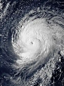 Hurricane Teddy shortly before peak intensity over the North Atlantic on September 17 | |
| Formed | September 12, 2020 |
|---|---|
| Dissipated | September 27, 2020 |
| (Extratropical after September 23) | |
| Highest winds | 1-minute sustained: 140 mph (220 km/h) |
| Lowest pressure | 945 mbar (hPa); 27.91 inHg |
| Fatalities | 3 total |
| Damage | > $35 million (2020 USD) |
| Areas affected | Lesser Antilles, Bermuda, East Coast of the United States, Atlantic Canada |
| Part of the 2020 Atlantic hurricane season | |
Tropical storm watches and warnings were issued for both Bermuda and Atlantic Canada in preparation for Teddy. Its large size and strength caused high waves and rip currents to impact areas hundreds of miles from its path, ranging from the Lesser and Greater Antilles to the East Coast of the United States and Atlantic Canada. Two people in Puerto Rico drowned from the strong waves while another drowned in New Jersey. Total damage is estimated to be at least $35 million.
Meteorological history
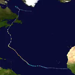
The National Hurricane Center (NHC) began to monitor a tropical wave over West Africa at 00:00 UTC on September 7.[1] Development of this wave was expected and at 00:00 UTC on September 9, it was given a high chance to develop within five days despite still being well inland.[2] The wave entered the Atlantic Ocean at 12:00 UTC on September 10, and began to steadily organize, forming a broad low-pressure area at 18:00 UTC on September 11, although its large size kept it from organizing quickly.[3][4] The next day, the low finally became more defined and at 21:00 UTC on September 12, the NHC designated the disturbance as Tropical Depression Twenty.[5]
At first, the depression struggled to organize for over a day due to its large size and moderate wind shear.[6] After the shear decreased, the system became better organized and strengthened into Tropical Storm Teddy at 09:00 UTC on September 14, becoming the earliest 19th tropical or subtropical storm on record in an Atlantic hurricane season, surpassing the old mark of October 4, which was previously set by the unnamed "Azores" subtropical storm in 2005.[7][8] It continued to intensify as it became better organized, with an eye beginning to form late on September 15.[9] It then rapidly intensified into a hurricane around 06:00 UTC the next day.[10] The storm continued to intensify, becoming a Category 2 hurricane later that day.[11] However, some slight westerly wind shear briefly halted intensification and even weakened the storm to a Category 1 at 03:00 UTC on September 17.[12] However, as the shear relaxed again, the storm began a second rapid intensification phase, becoming the season's second major hurricane at 15:00 UTC that day.[13] Teddy continued to intensify at a rapid pace and became a Category 4 hurricane six hours later, reaching its peak intensity of 140 mph (220 km/h) and a pressure of 945 mb (27.91 inHg).[14] Afterwards, internal fluctuation and an eyewall replacement cycle caused the storm to weaken slightly to a Category 3 hurricane at 09:00 UTC on September 18.[15] Soon after, Teddy briefly restrengthened into a Category 4 hurricane before another eyewall replacement cycle weakened it again.[16][17] Continued internal fluctuations caused the eye to nearly dissipate and Teddy weakened below major hurricane status at 12:00 UTC on September 20.[18] Teddy moved over slightly cooler waters caused by upwelling caused by Hurricane Paulette, contributing to its weakening trend.[19]
| Largest Atlantic hurricanes By diameter of gale-force winds | ||||
|---|---|---|---|---|
| Rank | System | Season | Diameter | |
| mi | km | |||
| 1 | Sandy | 2012 | 1,150 | 1,850 |
| 2 | Igor | 2010 | 920 | 1,480 |
| 3 | Olga | 2001 | 865 | 1,390 |
| 4 | Teddy | 2020 | 850 | 1,370 |
| 5 | Lili | 1996 | 805 | 1,295 |
| Sources: | ||||
Teddy continued moving north, weakening to a Category 1 hurricane as it began to merge with a trough late on September 21. At 15:00 UTC that day, the storm made its closest approach to Bermuda as a strong Category 1 hurricane before accelerating northwestwards away from the island.[20][21] A Hurricane hunters flight found that Teddy had strengthened a bit, due to a combination of baroclinic energy infusion from the trough and warm oceanic waters from the Gulf Stream and it was upgraded back to Category 2 status.[22] Teddy also doubled in size as a result of merging with the trough. The hurricane kept expanding and started an extratropical transition while it neared the Atlantic Canada coast. Although Teddy appeared to be a post-tropical cyclone, Hurricane hunters found a warm core, as well as increasing convection in Teddy's center. [23] Just before transitioning into an post-tropical cyclone, the diameter of gale-force winds measured up to 850 mi (1,370 km) across from northeast to southwest, making Teddy the 4th largest Atlantic hurricane on record.[24] By then, Teddy had weakened back down to a Category 1 hurricane before transitioning to a post-tropical cyclone at 00:00 UTC on September 23.[25] At 12:00 UTC, the storm made landfall near Ecum Secum, Nova Scotia with winds of 65 mph (105 km/h) with a minimum central pressure of 964 mb (28.47 inHg).[26] It continued to weaken and the NHC issued their final advisory at 03:00 UTC on September 24.[27] Post-Tropical Cyclone Teddy then accelerated northward before making a large loop north of Newfoundland and turning east, briefly strengthening back to a storm-force low before weakening again and losing its identity on September 27.[28]
Preparations, impact, and records

Large swells were generated by the storm, which affected the Lesser Antilles, the East Coast of the United States, Bermuda, and Atlantic Canada.[13] One buoy operated by the National Oceanic and Atmospheric Administration (NOAA) in the open northern Atlantic off the coast of Nova Scotia reported a wave height of 35 feet (11 m) early on September 22. Another wave height of 40 feet (12 m) was reported later in the day by the same buoy. Waves reached 42 feet (13 m) at another buoy just north of Teddy on the afternoon of September 22, with winds gusting near 70 mph (115 km/h).[29]
Bermuda
Tropical storm watches, which were later upgraded to warnings, were issued for Bermuda due to the impacts expected from Teddy.[30][31] The Government of Bermuda shut down the island on September 21, closing all government services such as public transportation and schools.[32] The L.F. Wade International Airport was closed during the storm, but reopened on September 22 after the storm passed.[33] 220 homes lost power on the island, mainly in Hamilton and Pembroke parishes. Beach erosion was also reported.[32]
United States

The National Weather Service warned of high winds and coastal flooding in eastern New England. A high wind warning was issued for Nantucket and coastal Plymouth County on September 22. In addition, a high surf advisory was issued for those areas and for Bristol County. A wind advisory was issued for other coastal communities on mainland Massachusetts. For all of Massachusetts, a Red Flag warning was issued, signalling that critical fire weather conditions were possible due dry weather and gusty winds.[34] In North Carolina, a coastal flood warning was in effect for the Northern Outer Banks and Hatteras Island until September 21, but minor coastal flooding was forecasted by the National Weather Service until September 22. A coastal flood advisory was extended to for Pamlico, Southern Craven, Carteret and coastal Oslow counties as well as Ocracoke Island and Core Banks until the afternoon of September 22. The same advisory for Beaufort County and Tyrrell Counties expired early on September 22. A high surf advisory was issued and extended for beaches north of Cape Lookout until September 23.[35]
On September 18, a man and a woman drowned in the waters off La Pocita Beach in Loíza, Puerto Rico due to the rip currents and churning waves that Teddy had caused in the north of the Lesser and Greater Antilles.[36][37] Charleston, South Carolina, experienced high tides topping out at major flood stage for three straight days from September 19 to 21. This was the first time such an event had been documented for three days in a row in records dating to at least 1934. The city reported some flooding in its historical downtown district, along with some other areas near the coast.[38] In North Carolina, coastal communities experienced beach erosion and coastal flooding. North Carolina Highway 12 was closed from September 20 to September 22 due to persistent storm surge and sand being carried onto the road. In addition, more than 80 dunes were washed away at Cape Hatteras National Seashore.[35] Rip currents along the eastern seaboard also led to a drowning near Point Pleasant Beach, New Jersey.[39] No rain was reported in Massachusetts, however wind gusts over 30 mph (50 km/h) were reported near Cape Cod.[34] In Maine, very large waves pounded the coast, drawing onlookers and surfers. A fence was taken out by storm surge in Scarborough. Emergency officials were on standby across southern Maine in case flooding became a hazard. In Camp Ellis, the storm threatened to erode the shoreline. Some people in the town decided to put up storm shutters during the storm in case houses were flooded.[40]
Canada

Tropical storm watches were issued as the storm approached Nova Scotia; these were later upgraded to warnings.[9] Municipal sports fields, all-weather fields, tracks and baseball diamonds were closed on September 23 and all bookings were cancelled. School was also cancelled for many regions around the province. Halifax Transit stopped services during most of the storm, but resumed its services at 12:00 ADT (15:00 UTC) on September 23. Ferry service began immediately, while buses became fully operational an hour later. The Halifax Public Gardens reopened at the same time as Halifax Transit, but residents and tourists were asked to avoid visiting municipal parks until the storm passed due to safety concerns.[41]
Teddy produced moderate to heavy rainfall in Nova Scotia, peaking at 131 millimetres (5.2 in) in Ingonish. In addition, a peak wind gust of 132 kilometres per hour (82 mph) was reported in Grand Étang.[41] In Bedford, the Sackville River overtopped its banks, flooding a nearby park.[42] Around 20,000 customers lost power across the province, but impacts in Nova Scotia were less than originally predicted.[43]
See also
- Tropical cyclones in 2020
- List of Category 4 Atlantic hurricanes
- List of Canada hurricanes
- List of Bermuda hurricanes
- Hurricane Gert (1999) – A hurricane that took an almost identical track.
- Hurricane Juan (2003) – One of the most devastating hurricanes to affect Atlantic Canada.
- Hurricane Bill (2009) – A Storm of similar strength that also affected Atlantic Canada.
- Hurricane Igor (2010) – Had a similar intensity and nearly identical track.
References
- Stacy Stewart (September 7, 2020). "Five-Day Graphical Tropical Weather Outlook". www.nhc.noaa.gov. Miami, Florida: National Hurricane Center. Archived from the original on September 16, 2020. Retrieved September 12, 2020.
- "NHC Graphical Outlook Archive". www.nhc.noaa.gov. Retrieved September 20, 2020.
- Robbie Berg (September 10, 2020). "Five-Day Graphical Tropical Weather Outlook". www.nhc.noaa.gov. Miami, Florida: National Hurricane Center. Archived from the original on September 16, 2020. Retrieved September 12, 2020.
- "NHC Graphical Outlook Archive". www.nhc.noaa.gov. Retrieved September 20, 2020.
- Andrew Latto (September 12, 2020). "Tropical Depression Twenty Public Advisory Number 1". www.nhc.noaa.gov. Miami, Florida: National Hurricane Center. Archived from the original on September 16, 2020. Retrieved September 12, 2020.
- Andrew Latto (September 12, 2020). "Tropical Depression Twenty Discussion Number 1". www.nhc.noaa.gov. Miami, Florida: National Hurricane Center. Archived from the original on September 16, 2020. Retrieved September 14, 2020.
- Stacy Stewart (September 14, 2020). "Tropical Storm Teddy Discussion Number 7". www.nhc.noaa.gov. Miami, Florida: National Hurricane Center. Archived from the original on September 16, 2020. Retrieved September 12, 2020.
- Marchante, Michelle; Harris, Harris (September 14, 2020). "With newly formed Tropical Storm Teddy, NHC tracking five named systems at once". The Miami Herald. Archived from the original on September 14, 2020. Retrieved September 14, 2020.
- "Hurricane TEDDY Advisory Archive". www.nhc.noaa.gov. Archived from the original on September 16, 2020. Retrieved September 14, 2020.
- "Hurricane TEDDY". www.nhc.noaa.gov. Archived from the original on September 16, 2020. Retrieved September 16, 2020.
- "Hurricane TEDDY". www.nhc.noaa.gov. Retrieved September 17, 2020.
- "Hurricane TEDDY". www.nhc.noaa.gov. Retrieved September 17, 2020.
- "Hurricane Teddy Public Advisory". National Hurricane Center. September 17, 2020. Retrieved September 17, 2020.
- Andrew Latto (September 17, 2020). "Hurricane Teddy Public Advisory Number 22". www.nhc.noaa.gov. Miami, Florida: National Hurricane Center. Retrieved September 17, 2020.
- John Cangialosi (September 18, 2020). "Hurricane Teddy Discussion Number 24". www.nhc.noaa.gov. Miami, Florida: National Hurricane Center. Retrieved September 18, 2020.
- Richard Pasch (September 19, 2020). "Hurricane Teddy Public Advisory Number 27". www.nhc.noaa.gov. Miami, Florida: National Hurricane Center. Retrieved September 19, 2020.
- David Zelinsky (September 19, 2020). "Hurricane Teddy Discussion Number 28". www.nhc.noaa.gov. Miami, Florida: National Hurricane Center. Retrieved September 19, 2020.
- "Hurricane TEDDY". www.nhc.noaa.gov. Retrieved September 21, 2020.
- "Hurricane TEDDY". www.nhc.noaa.gov. Retrieved January 24, 2021.
- "Hurricane TEDDY". www.nhc.noaa.gov. Retrieved September 23, 2020.
- "Hurricane TEDDY Discussion 38". www.nhc.noaa.gov. Retrieved September 22, 2020.
- "Hurricane TEDDY Discussion 39". www.nhc.noaa.gov. Retrieved September 22, 2020.
- Blake, Forecaster (September 22, 2020). "Hurricane Teddy Discussion Number 41". National Hurricane Center. Retrieved December 18, 2020.
- "Hurricane Teddy Forecast Advisory Number 42". www.nhc.noaa.gov. Retrieved September 23, 2020.
- "Post-Tropical Cyclone TEDDY". www.nhc.noaa.gov. Retrieved September 22, 2020.
- "Post-Tropical Cyclone TEDDY". www.nhc.noaa.gov. Retrieved September 24, 2020.
- "Post-Tropical Cyclone TEDDY". www.nhc.noaa.gov. Retrieved September 24, 2020.
- Service, NOAA's National Weather. "WPC Surface Analysis Archive". www.wpc.ncep.noaa.gov. Retrieved September 25, 2020.
- Sojda, Jake (September 22, 2020). "Powerful Teddy slams Atlantic Canada with driving rain, fierce wind and dangerous seas". accuweather.com. Accuweather. Retrieved October 2, 2020.
- "Hurricane TEDDY". www.nhc.noaa.gov. Retrieved September 19, 2020.
- "Hurricane TEDDY". www.nhc.noaa.gov. Retrieved September 19, 2020.
- Johnston-Barnes, Owain (September 22, 2020). "Island Escapes Worst of Ocean-Bound Teddy". The Royal Gazette (Bermuda). Retrieved October 20, 2020.
- ""Large" Hurricane Teddy to Pass Near Bermuda". Caribbean News Weekly. September 21, 2020. Retrieved October 20, 2020.
- Cote, Jackson (September 22, 2020). "Hurricane Teddy's impact on Massachusetts: Coastal flooding, large breaking waves as high as 24 feet and winds as strong as 55 mph in the forecast". MassLive. Retrieved October 2, 2020.
- "Distant Teddy Floods NC 12, Erodes Beaches | Coastal Review Online". www.coastalreview.org. September 21, 2020.
- "Dos personas mueren ahogadas en Piñones". Primera Hora. Retrieved September 18, 2020.
- "Los bañistas que visiten las playas del norte este fin de semana: "Podrían poner en riesgo sus vidas"". El Nuevo Día. Retrieved September 18, 2020.
- "'Ginormous' Hurricane Teddy Churned Up Surf on U.S. East Coast, Then Slammed Atlantic Canada as Post-Tropical Cyclone". The Weather Channel. September 24, 2020. Retrieved October 19, 2020.
- Chris Sheldon (September 25, 2020). "Swimmer dies after being pulled from ocean off Jersey Shore beach". nj.com. Retrieved September 28, 2020.
- Blanchard, Zach (September 22, 2020). "Hurricane Teddy brings huge waves, surfers and onlookers as it churns off Maine coast". newscentermain.com. New Center Maine. Retrieved October 2, 2020.
- https://www.cbc.ca/news/canada/nova-scotia/teddy-storm-nova-scotia-1.5735080
- Haley Ryan (September 23, 2020). "Post-tropical storm Teddy hits Nova Scotia without lasting damage". cbc.ca. CBC. Retrieved September 24, 2020.
- Michael MacDonald (September 23, 2020). "Post-tropical storm Teddy makes landfall in Nova Scotia bringing high winds, rain". thestar.com. The Star. Retrieved September 24, 2020.
External links
| Wikimedia Commons has media related to Hurricane Teddy. |
- NHC's archive on Hurricane Teddy
- National Hurricane Center website
- Bermuda Weather Service
- Hurricane teddy hit Dominican Republic coasts - Sep. 23, 2020
Tropical cyclones of the 2020 Atlantic hurricane season | ||
|---|---|---|
 | ||
| ||