A23 road
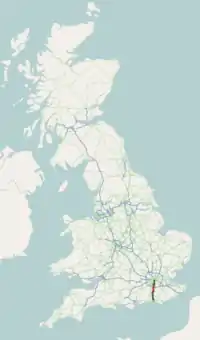
The A23 road is a major road in the United Kingdom between London and Brighton, East Sussex, England. It is managed by Transport for London for the section inside the Greater London boundary, Surrey County Council and West Sussex County Council for the section shadowed by the M23 motorway, the Highways Agency (as a trunk road) between the M23 and Patcham, and by Brighton and Hove Council from the A27 to the centre of Brighton.
| |
|---|---|
 | |
 The A23 near Patcham, East Sussex. | |
| Major junctions | |
| North end | London (Waterloo)51.498°N 0.112°W |
| South end | Brighton50.830°N 0.138°W |
| Location | |
| Primary destinations | Croydon Redhill Reigate Gatwick Airport Crawley |
| Road network | |
The road has been a major route for centuries, and seen numerous upgrades, bypasses and diversions.
Route
The A23 begins near Lambeth North tube station. Formerly, it started as Westminster Bridge Road near Waterloo station, but this is now part of the A302. Almost immediately it turns south; the straightness of much of the heading south shows its Roman origins.
The road becomes:
- Kennington Road: 1 mile (1.6 km) long; near Kennington Park it joins the A3 (Kennington Park Road), but soon bears south again, becoming in turn over the next 5 miles (8.0 km):
- Brixton Road
- Brixton Hill
- Streatham Hill
- Streatham High Road
- at Norbury the road becomes London Road; after 1.25 miles (2 km), at
- Thornton Heath the Croydon bypass, Thornton Road and then Purley Way (known for its superstores, particularly IKEA, and for the site of Croydon Airport) takes the place of the original road through Croydon, now the A235, rejoining the A23 at Purley near the Purley War Memorial Hospital, now named Brighton Road.
- continuing south through Coulsdon on the Farthing Way (the relief road for Coulsdon town centre, opened in 2006[1]), over the North Downs to Hooley, the start of the M23 motorway.
- here is now Surrey
- through the built-up areas of Merstham, Redhill and Salfords, skirting Horley
- here is now West Sussex
- making an end-on connection with the M23 spur to Gatwick Airport the A23 becomes a dual carriageway as it is diverted round the airport; it rejoins the original route at Lowfield Heath and continues south into Crawley as London Road
- Crawley ByPass: the original road was through the town
- Pease Pottage, southern junction with the M23
- through the relatively rural countryside of West Sussex, before following along valleys to cross the South Downs and entering Brighton
- becomes the London Road, Brighton, passing under the London Road railway viaduct
- the road ends at Old Steine, Brighton, at a roundabout intersecting with the coastal A259 road, and opposite the entrance to the Palace Pier.
Major roads intersected by the A23
- A3 and A202 at Kennington
- A205 South Circular Road at Streatham Hill
- A214 at Streatham
- A232 at Waddon
- M23 close to Junction 7 (no southbound access)
- A25 at Redhill
- A264 at Crawley
- M23 at Pease Pottage
- A272 at Bolney
- A27 Brighton Bypass at Mill Road Roundabout
History
What is now the A23 became an arterial route following the construction of Westminster Bridge in 1750 and the consequent improvement of roads leading to the bridge south of the river by the turnpike trusts. The increase in population of Brighton in the late eighteenth century, which transformed it from a small fishing village to a large seaside resort, enhanced the importance of this road, as did the residence there of George IV, as Prince of Wales, who made Brighton a place of fashion.
When roads were originally classified, the A23 started at Purley Cross.[2] The road north of this section, including Purley Way, which opened to traffic in April 1925,[3] was part of the A22. The current route north to Westminster Bridge dates from April 1935.[4]
The A23 in London has frequently been one of the city's most congested roads.[5][6] The M23 motorway was originally proposed to run as far north as Streatham, relieving congestion on the route, but the section north of Hooley was never built. At junction 7 of the M23 motorway, signs for the northbound M23 (which terminates a few miles to the north) simply read "Croydon" with no other London destinations marked.
In July 2000, control of the section of road inside the Greater London boundary was transferred from The Highways Agency to Transport for London.[7] This caused delays to a planned relief road of Coulsdon, which had been announced in 1998. The then mayor, Ken Livingstone apologised in 2002 that TfL was unable to construct the relief road due to a lack of funds.[8] The road was eventually completed in 2007, and which under TfL's ownership had acquired a bus lane that suffered ridicule for not having any buses actually running on it.[9]
On 18 March 2010, plans to widen the section between Handcross and Warninglid in West Sussex to three lanes, removing an accident prone bend, were given the go ahead. Work started in autumn 2011[10][11] and the scheme was completed and opened in October 2014, with a better-than-expected improvement to safety.[12]
London to Brighton Veteran Run
The 53-mile (85 km) road from London to Brighton forms the basis of the route of the annual London to Brighton Veteran Car Run. This is featured in the film Genevieve, although most of the rural motoring scenes were shot in Buckinghamshire. The A23 is also used for various other London to Brighton events, although in many cases part of the route diverges to parallel roads to reduce congestion or add variety.
See also
References
- "Coulsdon Town Centre regeneration scheme clear to progress as Coulsdon Relief Road opens". Archived from the original on 17 August 2012. Retrieved 2014-02-24.
- "List of Class I and Class II Roads and Numbers". HMSO. 1923. Retrieved 20 December 2012.
- "Purley Way and Valley Park". Croydon Online. Retrieved 20 December 2012.
- CLASSIFICATION: Re-numbering of classified routes, The National Archives, MT39/246
- "Air Pollution (London)". 20 July 1994. Retrieved 20 December 2012.
That monitoring exercise was carried out in the very heart of Streatham, at St. Leonard's junction, on the A23 London to Brighton road, one of London's busiest and most congested thoroughfares
- "Bus Companies, London". 22 May 1995. Retrieved 20 December 2012.
- "Coulsdon Inner Relief Road". Hansard. 3 July 2000. Retrieved 20 December 2012.
- "Road Building". Hansard. 15 October 2002. Retrieved 20 December 2012.
- "Bus lane or dead end?". Croydon Guardian. 14 March 2007. Retrieved 20 December 2012.
- "Plans to widen the A23 in West Sussex approved". BBC News. 17 March 2010. Retrieved 17 April 2013.
- "A23 Handcross to Warninglid - Road Projects - Highways Agency". Archived from the original on 11 October 2011. Retrieved 27 September 2011.
- "Post Opening Project Evaluation A23 Handcross to Warninglid One Year After Study". gov.uk. Highways England. March 2017. p. 4. Retrieved 19 August 2019.
External links
A roads in Zone 2 of the Great Britain road numbering scheme | ||
|---|---|---|
| South West | ||
|---|---|---|
| Area 3 | ||
| Area 4 | ||
| Area 5 (DBFO) | ||
| East | ||
| Area 7 | ||
| Area 9 | ||
| North West | ||
| Area 12 | ||
| Area 14 | ||
| Other DBFO | ||
| Toll roads | ||
City of Brighton and Hove | |||||||||||||
|---|---|---|---|---|---|---|---|---|---|---|---|---|---|
| Topics | |||||||||||||
| Events | |||||||||||||
| Culture | |||||||||||||
| Politics | |||||||||||||
| Transport |
| ||||||||||||
| Media | |||||||||||||
| Sport |
| ||||||||||||
| Buildings | |||||||||||||
| Parks | |||||||||||||
| Areas |
| ||||||||||||
| |||||||||||||