Acoustical oceanography
Acoustical oceanography is the use of underwater sound to study the sea, its boundaries and its contents.

History
Interest in developing echo ranging systems began in earnest following the sinking of the RMS Titanic in 1912. By sending a sound wave ahead of a ship, the theory went, a return echo bouncing off the submerged portion of an iceberg should give early warning of collisions. By directing the same type of beam downwards, the depth to the bottom of the ocean could be calculated.[1]
The first practical deep-ocean echo sounder was invented by Harvey C. Hayes, a U.S. Navy physicist. For the first time, it was possible to create a quasi-continuous profile of the ocean floor along the course of a ship. The first such profile was made by Hayes on board the U.S.S. Stewart, a Navy destroyer that sailed from Newport to Gibraltar between June 22 and 29, 1922. During that week, 900 deep-ocean soundings were made.[2]
Using a refined echo sounder, the German survey ship Meteor made several passes across the South Atlantic from the equator to Antarctica between 1925 and 1927, taking soundings every 5 to 20 miles. Their work created the first detailed map of the Mid-Atlantic Ridge. It showed that the Ridge was a rugged mountain range, and not the smooth plateau that some scientists had envisioned. Since that time, both naval and research vessels have operated echo sounders almost continuously while at sea.[3]
Important contributions to acoustical oceanography have been made by:
- Leonid Brekhovskikh
- Walter Munk
- Herman Medwin
- John L. Spiesberger
- C.C. Leroy
- David E. Weston
- D. Van Holliday
- Charles Greenlaw
Equipment used
The earliest and most widespread use of sound and sonar technology to study the properties of the sea is the use of a rainbow echo sounder to measure water depth. Sounders were the devices used that mapped the many miles of the Santa Barbara Harbor ocean floor until 1993.
Fathometers measure the depth of the waters. It works by electronically sending sounds from ships, therefore also receiving the sound waves that bounces back from the bottom of the ocean. A paper chart moves through the fathometer and is calibrated to record the depth.
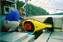
As technology advances, the development of high resolution sonars in the second half of the 20th century made it possible to not just detect underwater objects but to classify them and even image them. Electronic sensors are now attached to ROVs since nowadays, ships or robot submarines have Remotely Operated Vehicles (ROVs). There are cameras attached to these devices giving out accurate images. The oceanographers are able to get a clear and precise quality of pictures. The 'pictures' can also be sent from sonars by having sound reflected off ocean surroundings. Oftentimes sound waves reflect off animals, giving information which can be documented into deeper animal behaviour studies.[4][5][6]
Theory
See Clay and Medwin.[7]
Measurements
See Clay and Medwin.[7]
Applications
Applications of acoustical oceanography include:
- fish population surveys
- classification of fish species and other biota
- rain rate measurement
- wind speed measurement
- water depth measurement
- seabed classification
- ocean acoustic tomography
- global thermometry
- monitoring of ocean-atmospheric gas exchange
Depth sounding
Marine biology
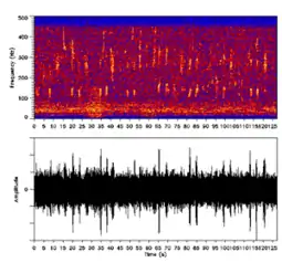
The study of marine life, from microplankton to the blue whale, uses bioacoustics.[8]
References
- Garrison, Tom. Essentials of Oceanography. 6th ed. Pacific Grove, CA: Brooks Cole, 2012. p.79.
- Kunzig, Robert. Mapping the Deep: The Extraordinary Story of Ocean Science. New York: Norton 2000. p. 40-41.
- Stewart, Robert. Introduction to Physical Oceanography, University Press of Florida, 2009 p. 28.
- "Oceanography". Scholastic Teachers.
- "Tools of the Oceanographer". marinebio.net.
- "Technology used". noc.ac.uk. Archived from the original on 2015-01-21. Retrieved 2015-01-21.
- C. S. Clay & H. Medwin, Fundamentals of Acoustical Oceanography (Academic, Boston, 1998).
- E. J. Simmonds & D. N. MacLennan, Fisheries Acoustics, Second Edition (Blackwell, Oxford, 2005).


