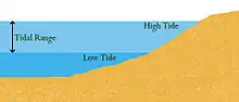
Tidal range
Tidal range is the height difference between high tide and low tide. Tides are the rise and fall of sea levels caused by gravitational forces exerted by the Moon and Sun and the rotation of Earth. Tidal range is not constant but changes depending on the locations of the Moon and Sun.
The most extreme tidal range occurs during spring tides, when the gravitational forces of both the Moon and Sun are aligned (syzygy), reinforcing each other in the same direction (new moon) or in opposite directions (full moon). During neap tides, when the Moon and Sun's gravitational force vectors act in quadrature (making a right angle to the Earth's orbit), the difference between high and low tides is smaller. Neap tides occur during the first and last quarters of the Moon's phases. The largest annual tidal range can be expected around the time of the equinox if it coincides with a spring tide.
Tidal data for coastal areas is published by national hydrographic services.[1] The data is based on astronomical phenomena and is predictable. Sustained storm-force winds blowing from one direction combined with low barometric pressure can increase the tidal range, particularly in narrow bays. Such weather-related effects on the tide, which can cause ranges in excess of predicted values and can cause localized flooding, are not calculable in advance.
Mean tidal range is calculated as the difference between Mean High Water (i.e., the average high tide level) and Mean Low Water (the average low tide level).[2]
Geography
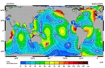
The typical tidal range in the open ocean is about 0.6 metres (2 feet) (blue and green on the map on the right). Closer to the coast, this range is much greater. Coastal tidal ranges vary globally and can differ anywhere from near zero to over 16 m (52 ft).[3] The exact range depends on the volume of water adjacent to the coast, and the geography of the basin the water sits in. Larger bodies of water have higher ranges, and the geography can act as a funnel amplifying or dispersing the tide.[4] The world's largest tidal range of 16.3 metres (53.5 feet) occurs in Bay of Fundy, Canada,[3][5] a similar range is experienced at Ungava Bay also in Canada[6] and the United Kingdom regularly experiences tidal ranges up to 15 metres (49 feet) between England and Wales in the Severn Estuary.[7]
The fifty coastal locations with the largest tidal ranges worldwide are listed by the National Oceanic and Atmospheric Administration of the United States.[3]
Some of the smallest tidal ranges occur in the Mediterranean, Baltic, and Caribbean Seas. A point within a tidal system where the tidal range is almost zero is called an amphidromic point.
Classification
The tidal range has been classified[9] as:
- Micro-tidal, when the tidal range is lower than 2 metres.
- Meso-tidal, when the tidal range is between 2 metres and 4 metres.
- Macro-tidal, when the tidal range is higher than 4 metres.
References
- Hydrographic and Oceanographic Agencies
- NOAA. "Tidal Datums". Retrieved 26 Mar 2019.
- NOAA. "FAQ2 Where are the highest tides?". Retrieved 23 Oct 2020.
- NOAA. "It appears that the range of the tides gets larger the further the location from the equator. What causes this??". Retrieved 23 Oct 2020.
- NOAA. "The highest tide in the world is in Canada". Retrieved 23 Oct 2020.
- Charles T. O'Reilly, Ron Solvason, and Christian Solomon. "Resolving the World's largest tides", in J.A Percy, A.J. Evans, P.G. Wells, and S.J. Rolston (Editors) 2005: The Changing Bay of Fundy-Beyond 400 years, Proceedings of the 6th Bay of Fundy Workshop, Cornwallis, Nova Scotia, Sept. 29, 2004 to October 2, 2004. Environment Canada-Atlantic Region, Occasional Report no. 23. Dartmouth, NS and Sackville, NB.
- "Tidal range".
- Picture credit: R. Ray, TOPEX/Poseidon: Revealing Hidden Tidal Energy GSFC, NASA. Redistribute with credit to R. Ray, as well as NASA-GSFC, NASA-JPL, Scientific Visualization Studio, and Television Production NASA-TV/GSFC
- Masselink, G.; Short, A. D. (1993). "The effect of tidal range on beach morphodynamics and morphology: a conceptual beach model". Journal of Coastal Research. 9 (3): 785–800. ISSN 0749-0208.