Adams Lake
Adams Lake is a large, deep, coldwater lake in British Columbia, Canada; its average depth ranks 6th in the world. The southern end of the lake is approximately 30 km (19 mi) north of the town of Chase in the Shuswap Country region of British Columbia. The lake's upper reaches lie in the northern Monashee Mountains, while its lower end penetrates the Shuswap Highland.[1] The lake supports Chinook, Sockeye and Coho salmon, Kokanee, mountain whitefish and rainbow trout.[2]
| Adams Lake | |
|---|---|
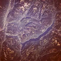 Adams Lake from space (August 1989) | |
 Adams Lake | |
| Location | British Columbia |
| Coordinates | 51°15′N 119°30′W |
| Primary inflows | Upper Adams River, Momich River, Bush Creek |
| Primary outflows | Lower Adams River |
| Basin countries | Canada |
| Max. length | 63 km (39 mi) |
| Max. width | 3.2 km (2.0 mi) |
| Surface area | 137 km2 (53 sq mi) |
| Average depth | 299 m (981 ft) |
| Max. depth | 457 m (1,499 ft) |
| Water volume | 23.2 km3 (5.6 cu mi) |
| Residence time | 10.4 years |
| Surface elevation | 404 m (1,325 ft) |
Geography
The lake is 63 km (39 mi) long and between 1.6 kilometres (0.99 mi) and 3.2 kilometres (2.0 mi) wide. The surface elevation is 404 metres (1,325 ft) above sea level. The lake is very deep; with a mean depth of 299 metres (981 ft) and maximum depth of 457 metres (1,499 ft) it is the second deepest lake in British Columbia (next to Quesnel Lake, which has a maximum depth of 511 metres (1,677 ft)) and 6th deepest lake in the world by mean depth. Water flows into the lake though many tributaries (most notably the Upper Adams River, Momich River, and Bush Creek). The water drains from the lake as the Lower Adams River which is home to a very large and famous sockeye salmon run which attracts many visitors to the region each year.[2] From there the water flows into Shuswap Lake, and down the Thompson River.
Though a few villages exist along Adams Lake, the vast majority of the lake is undeveloped. The lack of development is partially due to the nature of the shoreline, which is mostly sheer rock faces or steep, stony beaches. Few recreationally suitable beaches exist naturally on the lake. Some man-made sandy beaches have been constructed for public use. (see "Adams Lake Provincial Park")
History
Chief Adam (sometimes spelled Atahm) was a prominent Secwepemc chief in the mid-nineteenth century. By most accounts,[3][4] the lake is named after him. Adam died in the 1862 smallpox epidemic, which, according to James Teit,[5] killed over half the local Secwepemc population.
Adams Lake has been the site of two Secwepemc blockades, one in solidarity with the Kanesatake Mohawk in 1990, and the other in the summer of 1995, to prevent the development of a 60-unit recreational vehicle park on Secwepemc burial ground.[6]
The 1995 blockade resulted in the burning of the only bridge crossing the lake, and thus the establishment of a permanent inland ferry service to access the eastern side of the lake.
The north end of Adams Lake is called Mumix in the Shuswap language.[7]
Forestry
Forestry forms the economic base for the region. Unpaved logging roads, which provide the only land access, run the full length of the lake. At the south end of the lake operates a saw mill. The logs for which are harvested further up the lake, deposited into the lake near the Momich River by a large crane. The logs are then floated down the lake to the mill in log booms drawn by tug boats. It is a common sight to see these log booms anchored in wait at lakeside.
Recreation
Adams Lake is used for recreation year round. Sport anglers commonly fish the lake for Rainbow Trout, Kokanee, Lake trout, and Bull Trout. The lake is also used for swimming, pleasure boating and water skiing. The area around the lake is popular with campers and is home to a large variety of flora and fauna. During autumn and winter people hunt for game birds and big game such as mule deer, black bear, and cougar (mountain lion).
Climate
- Average Hours of Sunshine: 2,000+ per year
- Average Rainfall: 304.7 mm (11 in) annually
- Average Snowfall: 139.8 cm (55 in) in the valleys. Up to 644 cm (253.5 in) on the mountains
- Frost Free Days: 120–175 days annually
Average maximum temperature (summer): 28.4 °C (84 °F) Average minimum temperature (winter): -8.8 °C (16 °F)
See also
| Wikimedia Commons has media related to Adams Lake. |
References
- "Adams Lake". BC Geographical Names.
- "The Importance of Adams Lake & its Watershed" (PDF). BC Lake Stewardship Society and the BC Ministry of Environment and Climate Change Strategy.
- "Shuswap: The Forgotten Community", Dunn, Joyce, found in "Reflections: Thompson Valley Histories", eds. Norton, Wayne, and Schmidt, Wilf, Plateau Press, Kamloops, B.C., 1994, page 149
- "Shuswap History - The First 100 Years", Coffey, John et al, Secwepemc Cultural Education Society, Kamloops, B.C., 1990, pg. 18
- "The Shuswap, Memoirs #4, Part 7", Teit, James, American Museum of Natural History, 1909, page 466
- Secwepemc History of Resistance
- "Secwepemc Historical Sites". Secwepemculecw, Land of the Shuswap. Archived from the original on 2016-03-04. Retrieved 2012-09-06.
