Hecate Strait
Hecate Strait (/ˈhɛkɪt/; Haida language: K̲andaliig̲wii,[1] also siigaay which means simply "ocean") is a wide but shallow strait between Haida Gwaii (formerly the Queen Charlotte Islands) and the mainland of British Columbia, Canada. It merges with Queen Charlotte Sound to the south and Dixon Entrance to the north. About 140 kilometres (87 mi) wide at its southern end, Hecate Strait narrows in the north to about 48 kilometres (30 mi).[2] It is about 260 kilometres (160 mi) in length.[3]
| Hecate Strait | |
|---|---|
| French: Détroit d'Hécate | |
.JPG.webp) Hecate Strait and Pitt Island | |
 Hecate Strait | |
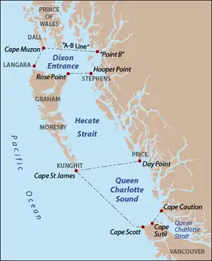 Hecate Strait as delineated by BCGNIS, along with Queen Charlotte Sound and Dixon Entrance. Red dots indicate capes and points, gray text indicates island names. | |
| Location | British Columbia, Canada |
| Coordinates | 53°11′N 130°50′W |
| Native name | K̲andaliig̲wii |
| Ocean/sea sources | Pacific Ocean |
| Max. length | 260 km (160 mi) |
| Max. width | 140 km (87 mi) |
| Settlements | Queen Charlotte, Skidegate, Sandspit, Tlell, Kitkatla |
Definition
According to the BCGNIS, the southern boundary of Hecate Strait is defined as a line running from the southernmost point of Price Island to Cape St James on Kunghit Island, the southernmost point of Haida Gwaii. The northern boundary is a line from Rose Point, the northeastern tip of Graham Island, to Hooper Point at the north end of Stephens Island off the mainland.[2]
History
Hecate Strait, because it is so shallow, is especially susceptible to storms and violent weather. The Haida crossed the Hecate Strait to the mainland to plunder coastal villages to take slaves and booty. Only the Haida knew the real nature of the Strait's workings, and so could not be followed by the tribes of the mainland. Hecate Strait, therefore, was one of the main defenses of the Haida people from attack.[4]
Hecate Strait was named by Captain George Henry Richards in 1861 or 1862 after his surveying vessel, HMS Hecate.[2]
Geology
During the last Ice Age, the seafloor in this area was a wide coastal plain stretching south to the Olympic Peninsula and including what is now Queen Charlotte Sound.[4]
Flora and fauna
The strait once contained strong salmon and halibut fisheries.
Hecate Strait is one of the few locations in the world with species from the glass sponge class of fauna. Regions with these sponge are currently protected from damage by commercial fishing.[5]
The Hecate Strait and Queen Charlotte Sound Glass Sponge Reefs Marine Protected Area was designated by the Fisheries and Oceans Canada in February 2017. The MPA is located in the Northern Shelf bioregion of the Pacific Region, southeast of Haida Gwaii, North and South of the entrance to the Douglas Channel. The MPA is composed of three individual areas known as the Northern Reef, the Central Reefs, and the Southern Reef. Together these three areas cover approximately 2,410 square kilometers.[6] The four reef complexes in the Hecate Strait and Queen Charlotte Sound discontinuously cover an area of about 1,000 km2, and are located in glacial troughs between 140 m and 240 m deep.
References
- Skidegate Haida Immersion Program, A Pocket Guide to the Skidegate Haida Language (forthcoming ed.)
- "Hecate Strait". BC Geographical Names.
- Hecate Strait Archived 2008-06-06 at the Wayback Machine, Columbia Gazetteer of North America
- "During the end of the last ice age between 13,000 and 11,000 years ago, events resulted in very low water levels around Haida Gwaii. What is now Hecate Strait, the body of water that separates Haida Gwaii from the mainland, was for the most part dry land. Throughout this area of dry land, there were lakes and small rivers draining north and south to the Pacific Ocean. Soil samples from Hecate Strait indicate that many areas were habitable in the last ice age. After 10,000 years ago, the melting glaciers contributed to a rise in the sea level that resulted in a flooding of the Northwest Coast, temporarily creating beach lines high above today's high tide marks". Canadian Museum of Civilization Corporation.
- Glass Sponge Reefs Archived 2010-08-15 at the Wayback Machine Living Oceans Society
- "Fisheries and Oceans Canada". www.dfo-mpo.gc.ca. Retrieved 2018-11-22.