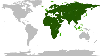
Afro-Eurasia
Afro-Eurasia[1] (or Afroeurasia,[2] or Eurafrasia[3]), nicknamed the World Island, is a landmass comprising the continents of Africa, Asia, and Europe. The terms are portmanteaus of the names of its constituent parts.[3] Its mainland is the largest contiguous landmass on Earth, as well as the most populous.
_political.svg.png.webp) | |
| Area | 84,980,532 km2 (32,811,167 sq mi) |
|---|---|
| Population | 6.6 billion |
| Demonym | Afro-Eurasian, Eurafrasian |
| Countries | 147 |
| Dependencies | 17 |
| Time zones | UTC-1 (Cape Verde) UTC+12 (Russian Far East) |
Afro-Eurasia encompasses 84,980,532 square kilometres (32,811,167 sq mi), 57% of the world's land area, and has a population of approximately 6 billion people, roughly 86% of the world population.[4]
Related terms
The following terms are used for similar concepts:
- The Ecumene: a term from classical antiquity for the world as was known to ancient Greek scholars, which was limited to Europe and parts of Asia and Africa.
- The Old World: a term from the Age of Discovery which, for European explorers, contrasted the previously known world from the New World of the Americas.
- The World Island: a term coined by H.J. Mackinder in his "The Geographical Pivot of History" (1904) and used in geopolitical contexts.[5] Mackinder defines the World Island as the large contiguous landmass, technically excluding islands such as Great Britain.[6] "Afro-Eurasia" generally includes those islands usually considered part of Africa, Europe and Asia.
Geology
Although Afro-Eurasia is typically considered to comprise two or three separate continents, it is not a proper supercontinent. Instead, it is the largest present part of the supercontinent cycle.
The oldest part of Afro-Eurasia is probably the Kaapvaal Craton, which together with Madagascar and parts of India and western Australia formed part of the first supercontinent Vaalbara or Ur around 3 billion years ago. It has made up parts of every supercontinent since. At the breakup of Pangaea around 200 million years ago, the North American and Eurasian Plates together formed Laurasia while the African Plate remained in Gondwana, from which the Indian Plate split off. This impacted southern Asia around 50 million years ago and began the formation of the Himalayas. (Around the same time, it also fused with the Australian Plate.) The Arabian Plate broke off of Africa around 30 million years ago and impacted the Iranian Plate between 19 and 12 million years ago, ultimately forming the Alborz and Zagros chains of Iranian Plate. After this initial connection of Afro-Eurasia, the Betic corridor along the Gibraltar Arc closed a little less than 6 million years ago, fusing Northwest Africa and Iberia together. This led to the nearly complete desiccation of the Mediterranean Basin, the Messinian salinity crisis. Eurasia and Africa were then again separated: the Zanclean Flood around 5.33 million years ago refilled the Mediterranean Sea through the Strait of Gibraltar and the Red Sea and Gulf of Suez Rifts further divided Africa from the Arabian Plate.
Today, Africa is joined to Asia only by a narrow land bridge (which has been split by the Suez Canal at the Isthmus of Suez) and remains separated from Europe by the straits of Gibraltar and Sicily. Paleogeologist Ronald Blakey has described the next 15 to 100 million years of tectonic development as fairly settled and predictable.[7] In that time, Africa is expected to continue drifting northward. It will close the Strait of Gibraltar [8] quickly evaporating the Mediterranean Sea.[9] No supercontinent will form within the settled time frame, however, and the geologic record is full of unexpected shifts in tectonic activity that make further projections "very, very speculative".[7] Three possibilities are known as Novopangaea, Amasia, and Pangaea Ultima.[10] In the first two, the Pacific closes and Africa remains fused to Eurasia, but Eurasia itself splits as Africa and Europe spin towards the west; in the last, the trio spin eastward together as the Atlantic closes.
Divisions
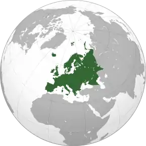
Normally, Afro-Eurasia is divided at the Suez Canal into Africa and Eurasia, the latter of which can be further subdivided into Europe and Asia. It has also been divided into Eurasia–North Africa and Sub-Saharan Africa for cultural and historical reasons.[11]
Extreme points
This is a list of the points that are farther north, south, east or west than any other location on Afro-Eurasia.
Afro-Eurasia (including nearby islands)
- Easternmost Point — Big Diomede†, Russia
- Northernmost Point — Cape Fligeli, Rudolf Island, Franz Josef Land, Russia
- Southernmost Point — Cape Agulhas, South Africa
- Westernmost Point — Santo Antão, Cape Verde or Monchique Islet, Azores, Portugal
Afro-Eurasia (mainland only)
- Easternmost Point — Cape Dezhnev†, Russia
- Northernmost Point — Cape Chelyuskin, Russia
- Southernmost Point — Cape Agulhas, South Africa
- Westernmost Point — Cap-Vert, Senegal
† According to the International Date Line.
See also
| Wikimedia Commons has media related to Afro-Eurasia. |
References
- Frank, Andre G. (1998), ReORIENT: Global Economy in the Asian Age, University of California Press, ISBN 978-0-520-21474-3
- Field, Henry. "The University of California African Expedition: I, Egypt", American Anthropologist, New Series Vol. 50, No. 3, Part 1 (Jul. - Sep., 1948), pp. 479-493.
- R. W. McColl, ed. (2005). 'continents' - Encyclopedia of World Geography, Volume 1. Golson Books, Ltd. p. 215. ISBN 9780816072293. Retrieved 2012-06-26.
And since Africa and Asia are connected at the Suez Peninsula, Europe, Africa, and Asia are sometimes combined as Afro-Eurasia or Eurafrasia.
- Based upon population estimates for 2007 cited in a UN report, World Population Prospects: The 2006 Revision (Highlights).
- Mackinder, Halford John. The Geographical Pivot of History.
- See Francis P. Sempa, Mackinder's World
- Manaugh, Geoff & al. "What Did the Continents Look Like Millions of Years Ago?" in The Atlantic online. 23 Sept 2013. Accessed 22 July 2014.
- "Future World". www.scotese.com.
- "Only the inflow of Atlantic water maintains the present Mediterranean level. When that was shut off sometime between 6.5 to 6 MYBP, net evaporative loss set in at the rate of around 3,300 cubic kilometers yearly. At that rate, the 3.7 million cubic kilometres of water in the basin would dry up in scarcely more than a thousand years, leaving an extensive layer of salt some tens of meters thick and raising global sea level about 12 meters." Cloud, P. (1988). Oasis in space. Earth history from the beginning, New York: W.W. Norton & Co. Inc., 440. ISBN 0-393-01952-7
- Williams, Caroline; Ted Nield (20 October 2007). "Pangaea, the comeback". NewScientist. Archived from the original on 13 April 2008. Retrieved 28 September 2009.
- Diamond, Jared (1997), Guns, Germs, and Steel: The Fates of Human Societies, Norton & Company, ISBN 0-393-03891-2
External links
- Interactive scholarly edition, with critical English translation and multimodal resources mashup (publications, images, videos) Engineering Historical Memory.
Continents of Earth | ||||||||
|---|---|---|---|---|---|---|---|---|
| ||||||||
| ||||||||
| ||||||||
.svg.png.webp)
.svg.png.webp)
.svg.png.webp)
.svg.png.webp)
.svg.png.webp)
.svg.png.webp)
.svg.png.webp)
.svg.png.webp)