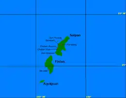
Aguigan
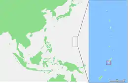
Aguigan or Aguiguan (also known as Aguihan, based on the Spanish rendition of the native name, "Aguijan", which is still often used as well) is a small bean-shaped coralline island in the Northern Mariana Islands chain in the Pacific Ocean. It is situated 8 kilometers (5.0 mi) south-west of Tinian, from which it is separated by the Tinian Channel. Aguigan and neighboring Tinian Island together form Tinian Municipality, one of the four main political divisions that comprise the Northern Marianas.
 | |
 | |
| Geography | |
|---|---|
| Location | Pacific Ocean |
| Coordinates | 14°51′13″N 145°33′34″E |
| Archipelago | Northern Mariana Islands |
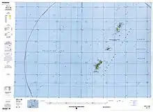
| Area | 7.01 km2 (2.71 sq mi)[1] |
| Length | 4.7 km (2.92 mi) |
| Width | 1.8 km (1.12 mi) |
| Highest elevation | 157 m (515 ft) |
| Administration | |
United States | |
| Commonwealth | Northern Mariana Islands |
| Demographics | |
| Population | - uninhabited - (2010) |
History
It is likely that first sighting by Europeans occurred during the Spanish expedition of Ferdinand Magellan, or by its continuation by Gonzalo Gómez de Espinosa being charted as Santo Ángel. It was visited by the Spanish missionary Diego Luis de San Vitores in 1669.[2]
Aguigan was administered as part of the Spanish Mariana Islands from the 16th century to 1899, when the Northern Marianas were sold by Spain to the German Empire. Under Germany, it administered as part of German New Guinea. During World War I, Aguigan came under the control of the Empire of Japan and was administered as part of the South Seas Mandate. During World War II, the Imperial Japanese Army maintained a garrison on Aguigan. This garrison is noteworthy because of its surrender to Allied forces September 4, 1945, two days after the surrender of Japan on the USS Missouri (BB-63). The surrender is unique because it was the only surrender hosted by a U.S. Coast Guard Cutter, USCG 83525. US Navy Admiral Marshall R. Greer received the surrender of the Japanese Second Lieutenant Kinichi Yamada.[3]
Following World War II, Aguigan came under the control of the United States and was administered as part of the Trust Territory of the Pacific Islands. Since 1978, the island has been part of the Commonwealth of the Northern Mariana Islands.
Geography
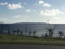
Aguigan is only 7.09 square kilometers (2.74 sq mi) in size, with a length of 4.7 km (2.9 mi) and a width of 1.8 km (1.1 mi). It is nicknamed “Goat Island” due to the large number of feral goats present there. Much of the native vegetation on Aguigan has been destroyed by goats.
Aguigan is uninhabited and is seldom visited because it is surrounded by sheer steep cliffs. However, a 2002 survey of the island did find a handful of native species there, including the Mariana fruit bat, the Polynesian sheath-tailed bat and the Micronesian megapode Megapodius laperouse.
Naftan Rock

Approximately 1 kilometer (0.62 mi) off the south-west shore of Aguigan is Naftan Rock, 18 meters (59 ft) in elevation.[4]
Important Bird Area
Aguigan and Naftan Rock have been recognised as an Important Bird Area (IBA) by BirdLife International because they support populations of Micronesian megapodes, white-throated ground doves, Mariana fruit doves, Mariana swiftlets, Micronesian myzomelas, rufous fantails, Aguiguan reed warblers, golden and Saipan white-eyes, and Micronesian starlings. Aguigan also supports seabird breeding colonies, with 120 pairs of brown boobies and 450 pairs of brown noddies reported, while Naftan Rock is home to several thousand seabirds. [5]
References
- Russell E. Brainard et al.: Coral reef ecosystem monitoring report of the Mariana Archipelago: 2003–2007. (=PIFSC Special Publication, SP-12-01) NOAA Fisheries, Pacific Islands Fisheries Science Center 2012
External links
- U.S. Coast Guard Historian's Office, Daily Chronology of Coast Guard History (Entry for 4 September)
- archive
- Pascal Horst Lehne and Christoph Gäbler: Über die Marianen. Lehne-Verlag, Wohldorf in Germany 1972. and Aguijan
- Google: Aguijan
From the website https://web.archive.org/web/20110728145947/http://www.uscg83footers.org/new_page_8.htm - Vessel corrected to be the Coast Guard Cutter 83525 Researched by Larry Richter, USCG Ret
Notes
- "6 AGUIJAN" (PDF). National Oceanic and Atmospheric Administration. p. 1. Archived (PDF) from the original on 15 November 2020. Retrieved 15 November 2020.
- Burney, James A chronological history of the discoveries in the South Sea or Pacific Ocean London, 1803, vI, p.57.
- "September Daily Chronology of Coast Guard History (Entry for September 4)" (PDF). U.S. Coast Guard Historian's Office. Retrieved January 18, 2019.
- "Aguijan Optical Validation - NOAA Nautical Chart #8 1067". University of Hawaii. NOAA. Retrieved 20 October 2018.
- "Aguiguan Island and Naftan Rock". BirdLife Data Zone. BirdLife International. 2021. Retrieved 8 February 2021.
| Colonies |
| |||||
|---|---|---|---|---|---|---|
| Concessions |
| |||||
| Unrecognised |
| |||||
