WD postcode area
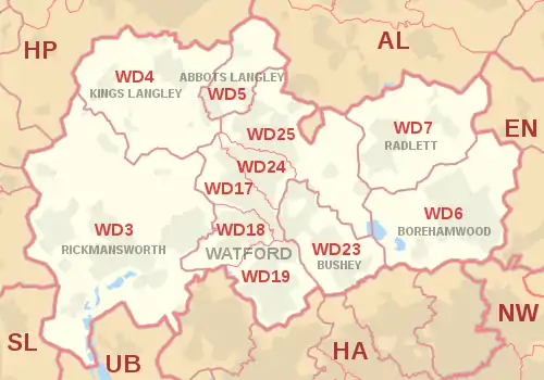
The WD postcode area, also known as the Watford postcode area,[2] is a group of eleven postcode districts in south-east England, within seven post towns. These cover south-west Hertfordshire (including Watford, Rickmansworth, Borehamwood, Kings Langley, Abbots Langley, Bushey and Radlett), plus very small parts of Buckinghamshire and Greater London.
Watford | |
|---|---|
 WD | |
| Coordinates: 51.661°N 0.390°W | |
| Country | United Kingdom |
| Postcode area | WD |
| Postcode area name | Watford |
| Post towns | 7 |
| Postcode districts | 14 |
| Postcode sectors | 70 |
| Postcodes (live) | 7,344 |
| Postcodes (total) | 15,889 |
| Statistics as at May 2020[1] | |
Mail for this area is sorted at the Home Counties North Mail Centre in Hemel Hempstead, having been sorted at the Watford Mail Centre until its closure in 2011.[3] The area covered includes all of the borough of Watford, most of the Three Rivers district, the western part of the Hertsmere district and small parts of the Dacorum and St Albans districts. WD3 also covers the village of Chenies in Buckinghamshire, plus a small protrusion of Harefield in the London Borough of Hillingdon.
Coverage
The approximate coverage of the postcode districts:
| Postcode district | Post town | Coverage | Local authority area(s) |
|---|---|---|---|
| WD3 | RICKMANSWORTH | Rickmansworth, Chorleywood, Croxley Green, Loudwater, Mill End, Maple Cross, Sarratt, Batchworth, Chenies, Harefield (part), West Hyde, Heronsgate, Chandler's Cross | Three Rivers, Buckinghamshire, Hillingdon |
| WD4 | KINGS LANGLEY | Kings Langley, Chipperfield, Hunton Bridge, Rucklers Lane, Bucks Hill | Dacorum, Three Rivers |
| WD5 | ABBOTS LANGLEY | Abbots Langley, Bedmond | Three Rivers, St Albans |
| WD6 | BOREHAMWOOD | Borehamwood, Elstree, Well End | Hertsmere |
| WD7 | RADLETT | Radlett, Shenley | Hertsmere, St Albans |
| WD17 | WATFORD | Watford town centre, Cassiobury, Nascot Wood | Watford |
| WD18 | WATFORD | West Watford, Holywell | Watford |
| WD19 | WATFORD | Oxhey, South Oxhey, Carpenders Park | Three Rivers, Watford |
| WD23 | BUSHEY | Bushey, Bushey Heath | Hertsmere, Watford |
| WD24 | WATFORD | North Watford | Watford |
| WD25 | WATFORD | Garston, Leavesden, Aldenham, Letchmore Heath | Watford, Hertsmere, Three Rivers, St Albans |
| WD99 | WATFORD | Jobcentre Plus | non-geographic |
Recoding
In September 2000 districts WD17-19 and WD23-25 were created from the recoding of the WD1 and WD2 districts. BUSHEY is a new post town; having previously been part of the WD2 district of WATFORD. This was due to postcode exhaustion of WD1 and WD2 [4] Another reason for the postcode revision was the old WD2 area included Bushey with North Watford. Bushey was to all intents a section of Watford sorting office; up until 2000, all mail for WD2 was cut and tipped at Watford office. In order to change this, new codes were created to enable direct bags to be opened at Bushey delivery office.
Map
References
- "ONS Postcode Directory Version Notes" (ZIP). National Statistics Postcode Products. Office for National Statistics. May 2020. Table 2. Retrieved 19 June 2020. Coordinates from mean of unit postcode points, "Code-Point Open". OS OpenData. Ordnance Survey. February 2012. Retrieved 21 April 2012.
- Royal Mail, Address Management Guide, (2004)
- Pickard, Michael (1 December 2010). "Strikes 'ruled out' after Royal Mail closes Watford depot". Watford Observer. Retrieved 22 April 2018.
- Royal Mail - Postcode Update 31 (September 2000)
