Alfred and Plantagenet
Alfred and Plantagenet is a township in eastern Ontario, Canada, in the United Counties of Prescott and Russell. Located approximately 70 km (43 mi) from downtown Ottawa at the confluence of the Ottawa River and the South Nation River.
Alfred and Plantagenet | |
|---|---|
| Township of Alfred and Plantagenet Canton d'Alfred et Plantagenet | |
 | |
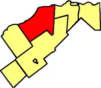 Location within Prescott and Russell | |
 Alfred and Plantagenet Location within southern Ontario | |
| Coordinates: 45°34′N 74°55′W | |
| Country | Canada |
| Provinces | Ontario |
| County | Prescott and Russell |
| Formed | January 1, 1997 |
| Government | |
| • Mayor | Stéphane Sarrazin |
| • Federal riding | Glengarry—Prescott—Russell |
| • Prov. riding | Glengarry—Prescott—Russell |
| Area | |
| • Land | 392.31 km2 (151.47 sq mi) |
| Population (2016)[1] | |
| • Total | 9,680 |
| • Density | 24.7/km2 (64/sq mi) |
| Time zone | UTC-5 (EST) |
| • Summer (DST) | UTC-4 (EDT) |
| Postal Code FSA | K0B |
| Area code(s) | 613 |
| Website | www |
The township was formed on January 1, 1997, through the amalgamation of Alfred Township, Alfred Village, North Plantagenet Township, and Plantagenet Village.
Plantagenet is from the royal house established by King Henry II. Settled in 1811-12. Post office from 1838.[2]
Near the town of Alfred, the Ontario Ministry of Natural Resources has designated the Alfred Bog as "a provincially significant wetland and an Area of Natural and Scientific Interest." Species of interest include the palm warbler, northern pitcher-plant, pink lady's-slipper, cottongrass, bog elfin and bog copper butterflies, and ebony boghaunter dragonfly. It also hosts one of the most southerly herds of moose. The bog is open to the public with a 272-metre (892 ft) boardwalk for nature walks.[3]
Communities
The township comprises the communities of Alfred, Alfred Station, Blue Corners, Centrefield, Coin Gratton, Curran, Glenburn, Jessups Falls, Lefaivre, Pendleton, Plantagenet, Plantagenet Station, Rockdale, Senecal, The Rollway, Treadwell, Wendover, and Westminster. The township administrative offices are located in Plantagenet.
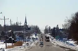
 Main street in Alfred
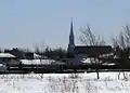 Skyline of Plantagenet
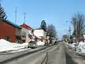
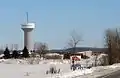 Wendover
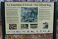 The Alfred Bog trail sign
Demographics
| Canada census – Alfred and Plantagenet community profile | |||
|---|---|---|---|
| 2016 | 2011 | 2006 | |
| Population: | 9,680 (+5.3% from 2011) | 9,196 (+6.3% from 2006) | 8,654 (+0.7% from 2001) |
| Land area: | 392.31 km2 (151.47 sq mi) | 392.45 km2 (151.53 sq mi) | 391.68 km2 (151.23 sq mi) |
| Population density: | 24.7/km2 (64/sq mi) | 23.4/km2 (61/sq mi) | 22.1/km2 (57/sq mi) |
| Median age: | 46.6 (M: 46.2, F: 47.0) | 42.7 (M: 42.2, F: 43.0) | |
| Total private dwellings: | 4,218 | 3,922 | 3,581 |
| Median household income: | $70,873 | $52,816 | |
| References: 2016[1] 2011[4] 2006[5] earlier[6] | |||
| Year | Pop. | ±% |
|---|---|---|
| 2001 | 8,593 | — |
| 2006 | 8,654 | +0.7% |
| 2011 | 9,196 | +6.3% |
| 2016 | 9,680 | +5.3% |
| [7] | ||
See also
References
- "2016 Community Profiles". 2016 Canadian Census. Statistics Canada. February 21, 2017. Retrieved 2019-07-01.
- Hamilton, William (1978). The Macmillan Book of Canadian Place Names. Toronto: Macmillan. p. 166. ISBN 0-7715-9754-1.
- The Alfred Bog Archived 2011-07-21 at the Wayback Machine, Ottawa Field-Naturalists' Club
- "2011 Community Profiles". 2011 Canadian Census. Statistics Canada. July 5, 2013. Retrieved 2012-02-28.
- "2006 Community Profiles". 2006 Canadian Census. Statistics Canada. March 30, 2011. Retrieved 2012-02-28.
- "2001 Community Profiles". 2001 Canadian Census. Statistics Canada. February 17, 2012.
- Statistics Canada: 2001, 2006, 2011, 2016 census
| Wikimedia Commons has media related to Alfred and Plantagenet. |
Places adjacent to Alfred and Plantagenet | |
|---|---|