Allan, Queensland
Allan is a rural locality in the Southern Downs Region, Queensland, Australia.[2] It was formerly known as Sandy Creek. In the 2016 census, Allan had a population of 87 people.[1]
| Allan Queensland | |||||||||||||||
|---|---|---|---|---|---|---|---|---|---|---|---|---|---|---|---|
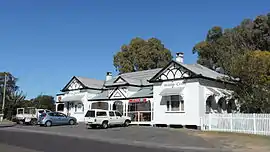 Darling Downs Hotel erected 1920s | |||||||||||||||
 Allan | |||||||||||||||
| Coordinates | 28.1972°S 151.9502°E | ||||||||||||||
| Population | 87 (2016 census)[1] | ||||||||||||||
| • Density | 10.00/km2 (25.90/sq mi) | ||||||||||||||
| Postcode(s) | 4370 | ||||||||||||||
| Area | 8.7 km2 (3.4 sq mi) | ||||||||||||||
| Time zone | AEST (UTC+10:00) | ||||||||||||||
| Location | |||||||||||||||
| LGA(s) | Southern Downs Region | ||||||||||||||
| State electorate(s) | Southern Downs | ||||||||||||||
| Federal Division(s) | Maranoa | ||||||||||||||
| |||||||||||||||
Geography
The Condamine River forms the north-eastern boundary of the locality, while Sandy Creek flows through the locality from Leslie Dam (the locality) to the west towards Leslie to the north-west (eventually becoming a tributary of the Condamine River.[3]
The Cunningham Highway passes through the locality from the south-east (Rosenthal Heights) towards the west (Leslie Dam). The South Western railway line runs roughly parallel to the south of the highway; there is no railway station within the locality. Major arterial roads in the locality are Sandy Creek Road which runs from the highway north-west to Leslie. The Leslie Dam Road runs south from the highway towards the Leslie Dam.[3]
The predominant land is agriculture, both cropping and grazing.[3]
History
The locality is named after botanist and explorer Allan Cunningham.[4] The district was formerly known as Sandy Creek after the local creek.[5]
A number of hotels were built at Sandy Creek in 1866. Adam Smith built the Darling Downs Hotel (locally known as the Sandy Creek Pub) in 1875.[6] It operated as a coach stop for changing horses from 1880 until the railway opened in 1904. In the 1920s, the old Darling Downs Hotel was replaced with the current building.[7]
Sandy Creek Provisional School on 13 May 1872. The school and residence were built by W. Wallace and H. Marshall for £304/10/0. In 1929 it became Allan State School. It closed in December 1967.[5][8][9]
St Matthew's Anglican Church was opened on 17 November 1901. It closed in 1969 and the church building was relocated to the Slade School in Warwick.[10]
The South Western railway opened from Warwick to Thane on 1 July 1904 with Allan railway station (28.1987°S 151.9497°E) serving the local area.[11][12] As at December 2019, Allan railway station is designated as an abandoned railway station.[13]
Heritage listings
Allan has the following heritage sites:
- 280 Sandy Creek Road (28.1866°S 151.9526°E): Allan State School (formerly Sandy Creek School)[5]
- 345 Sandy Creek Road (28.1837°S 151.9467°E): Darling Downs Hotel (Sandy Creek Pub)[7]
Education
There are no schools in Allan. The nearest primary schools are Wheatvale State School in Wheatvale to the north-west and Warwick West State School in Warwick to the south-east. The nearest secondary school is Warwick State High School in Warwick to the east.[3]
Attractions
The Sandy Creek Raceway of the Warwick Kart Club is at 335 Sandy Creek Road (28.1846°S 151.9480°E).[14]
References
- Australian Bureau of Statistics (27 June 2017). "Allan (SSC)". 2016 Census QuickStats. Retrieved 20 October 2018.

- "Allan – locality in Southern Downs Region (entry 45903)". Queensland Place Names. Queensland Government. Retrieved 5 November 2019.
- "Queensland Globe". State of Queensland. Retrieved 3 September 2020.
- "Allan (entry 45903)". Queensland Place Names. Queensland Government. Retrieved 13 March 2014.
- "Allan State School (former) (entry 650092)". Queensland Heritage Register. Queensland Heritage Council. Retrieved 3 September 2020.
- "Advertising". Warwick Examiner And Times. IX (421). Queensland, Australia. 27 March 1875. p. 1. Archived from the original on 3 September 2020. Retrieved 3 September 2020 – via National Library of Australia.
- Cultural Heritage Survey. 2. Southern Downs Regional Council. 2010. p. 112.
- "Opening and closing dates of Queensland Schools". Queensland Government. Retrieved 18 April 2019.
- "Agency ID 6347, Allan State School". Queensland State Archives. Retrieved 14 June 2015.
- "Closed Churches". Anglican Church of Southern Queensland. Archived from the original on 3 April 2019. Retrieved 24 February 2019.CS1 maint: unfit URL (link)
- Kerr, John (1990). Triumph of narrow gauge : a history of Queensland Railways. Boolarong Publications. p. 224. ISBN 978-0-86439-102-5.
- "Pratten" (Map). Queensland Government. 1944. Archived from the original on 3 September 2020. Retrieved 3 September 2020.
- "Railway stations and sidings - Queensland". Queensland Spatial Catalogue (Downloadable geospatial dataset). Queensland Government. Retrieved 3 September 2020.
- "Warwick Kart Club – The friendly place to race". Archived from the original on 3 September 2020. Retrieved 3 September 2020.
Further reading
External links
![]() Media related to Allan, Queensland at Wikimedia Commons
Media related to Allan, Queensland at Wikimedia Commons