Altona, Colorado
Altona is an unincorporated community and a census-designated place (CDP) located in Boulder County, Colorado, United States. The population of the Altona CDP was 501 at the United States Census 2010.[4] Boulder County governs the unincorporated community. The Boulder post office (Zip Code 80302) serves the area.[3]
Altona, Colorado | |
|---|---|
 Location of the Altona CDP in Boulder County, Colorado | |
 Altona Location of the Altona CDP in the United States. | |
| Coordinates: 40°07′31″N 105°17′33″W[1] | |
| Country | |
| State | |
| County | Boulder County |
| Government | |
| • Type | unincorporated community |
| Area | |
| • Total | 1.743 sq mi (4.515 km2) |
| • Land | 1.686 sq mi (4.366 km2) |
| • Water | 0.058 sq mi (0.149 km2) |
| Elevation | 5,928 ft (1,807 m) |
| Population (2010) | |
| • Total | 501 |
| • Density | 297/sq mi (115/km2) |
| Time zone | UTC-7 (MST) |
| • Summer (DST) | UTC-6 (MDT) |
| ZIP Code[3] | Boulder 80302 |
| Area codes | 303 & 720 |
| GNIS feature[2] | Altona CDP |
Geography
Altona is located in central Boulder County where Left Hand Creek exits the Front Range of the Colorado Rockies. U.S. Highway 36 passes through the community, leading north to Lyons and south to Boulder. Altona is 10 miles (16 km) west of Longmont by Nelson Road.
The Altona CDP has an area of 1,116 acres (4.515 km2) including 37 acres (0.149 km2) of water.[1]
Demographics
The United States Census Bureau initially defined the Altona CDP for the United States Census 2010.
| Year | Pop. | ±% |
|---|---|---|
| 2010 | 501 | — |
| 2020 | — | |
| Source: United States Census Bureau | ||
See also
References
- "State of Colorado Census Designated Places - BAS20 - Data as of January 1, 2020". United States Census Bureau. Retrieved December 2, 2020.
- "U.S. Board on Geographic Names: Domestic Names". United States Geological Survey. Retrieved December 2, 2020.
- "Zip Code 80302 Map and Profile". zipdatamaps.com. 2020. Retrieved December 20, 2020.
- "2010: DEC Summary File 1". United States Census Bureau. Retrieved December 20, 2020.
External links
Municipalities and communities of Boulder County, Colorado, United States | ||
|---|---|---|
| Cities | 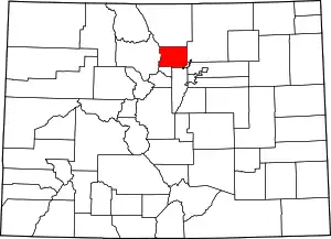 Map of Colorado highlighting Boulder County | |
| Towns | ||
| CDPs | ||
| Unincorporated communities | ||
| Ghost towns |
| |
| Footnotes | ‡This populated place also has portions in an adjacent county or counties | |
| ||
