Leyner, Colorado
Leyner is an unincorporated community and a census-designated place (CDP) located in and governed by Boulder County, Colorado, United States. The CDP is a part of the Boulder, CO Metropolitan Statistical Area. The population of the Leyner CDP was 29 at the United States Census 2010.[4] The Lafayette post office (Zip Code 80026) serves the area.[3]
Leyner, Colorado | |
|---|---|
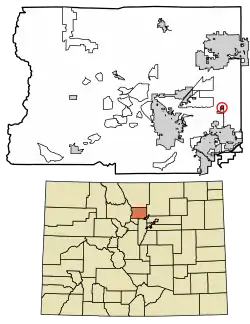 Location of the Leyner CDP in Boulder County, Colorado. | |
 Leyner Location of the Leyner CDP in the United States. | |
| Coordinates: 40°03′04″N 105°06′27″W[1] | |
| Country | |
| State | |
| County | Boulder County |
| Government | |
| • Type | unincorporated community |
| Area | |
| • Total | 0.236 sq mi (0.612 km2) |
| • Land | 0.195 sq mi (0.506 km2) |
| • Water | 0.041 sq mi (0.106 km2) |
| Elevation | 5,033 ft (1,534 m) |
| Population (2010) | |
| • Total | 29 |
| • Density | 149/sq mi (57/km2) |
| Time zone | UTC-7 (MST) |
| • Summer (DST) | UTC-6 (MDT) |
| ZIP Code[3] | Lafayette 80026 |
| Area codes | 303 & 720 |
| GNIS feature[2] | Leyner CDP |
Geography
Leyner is located in eastern Boulder County along the west side of U.S. Route 287, 4 miles (6 km) north of Lafayette. Boulder Creek forms the northern edge of the CDP.
The Leyner CDP has an area of 151 acres (0.612 km2), including 26 acres (0.106 km2) of water.[1]
Demographics
The United States Census Bureau initially defined the Leyner, CDP for the United States Census 2010.
| Year | Pop. | ±% |
|---|---|---|
| 2010 | 29 | — |
| 2020 | — | |
| Source: United States Census Bureau | ||
See also
References
- "State of Colorado Census Designated Places - BAS20 - Data as of January 1, 2020". United States Census Bureau. Retrieved December 8, 2020.
- "U.S. Board on Geographic Names: Domestic Names". United States Geological Survey. Retrieved December 8, 2020.
- "Zip Code 80026 Map and Profile". zipdatamaps.com. 2020. Retrieved December 20, 2020.
- "2010: DEC Summary File 1". United States Census Bureau. Retrieved December 20, 2020.
External links
Municipalities and communities of Boulder County, Colorado, United States | ||
|---|---|---|
| Cities | 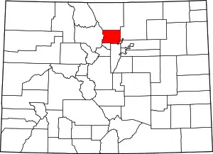 Map of Colorado highlighting Boulder County | |
| Towns | ||
| CDPs | ||
| Unincorporated communities | ||
| Ghost towns |
| |
| Footnotes | ‡This populated place also has portions in an adjacent county or counties | |
| ||
This article is issued from Wikipedia. The text is licensed under Creative Commons - Attribution - Sharealike. Additional terms may apply for the media files.
