Crisman, Colorado
Crisman is an unincorporated community and a census-designated place (CDP) located in and governed by Boulder County, Colorado, United States. The CDP is a part of the Boulder, CO Metropolitan Statistical Area. The population of the Crisman CDP was 186 at the United States Census 2010.[4] The Boulder post office (Zip Code 80302) serves the area.[3]
Crisman, Colorado | |
|---|---|
 Location of the Crisman CDP in Boulder County, Colorado. | |
 Crisman Location of the Crisman CDP in the United States. | |
| Coordinates: 40°02′30″N 105°22′03″W[1] | |
| Country | |
| State | |
| County | Boulder County |
| Founded | 1874 |
| Government | |
| • Type | unincorporated community |
| Area | |
| • Total | 1.457 sq mi (3.774 km2) |
| • Land | 1.457 sq mi (3.774 km2) |
| • Water | 0.0002 sq mi (0.0004 km2) |
| Elevation | 6,578 ft (2,005 m) |
| Population (2010) | |
| • Total | 186 |
| • Density | 127/sq mi (49.1/km2) |
| Time zone | UTC-7 (MST) |
| • Summer (DST) | UTC-6 (MDT) |
| ZIP Code[3] | Boulder 80302 |
| Area codes | 303 & 720 |
| GNIS feature[2] | Crisman CDP |
History
Crisman was founded in 1874 as a mining camp and named after the adjacent Crisman Mill, an ore-processing mill owned by prospector and early settler Obed Crisman. Crisman became a boomtown in 1881, when the Yellow Pine Mine produced a massive silver strike. Crisman became a stop on the Greeley, Salt Lake and Pacific Railway. The Panic of 1893 and the subsequent crash of the silver market severely damaged Crisman's economy, although the nearby mines remained open for the duration. In 1894, Boulder Creek flooded, and much of the town was destroyed, including a section of railroad track. The obliterated structures were never rebuilt, and Crisman was significantly reduced in size. In 1901, the Logan Mine, a large gold operation near Crisman, uncovered a second strike, which prevented the town from disappearing altogether. By 1918, Crisman had become increasingly depopulated, and the post office closed that year. In 1919, another catastrophic flood swept through Fourmile Canyon, again destroying a section of railroad track and leaving little left of Crisman. The town has since been reduced to a hamlet.[5][6]
Geography
Crisman is located in central Boulder County in the Front Range of the Colorado Rocky Mountains, in the valley of Fourmile Creek at an elevation of 6,578 feet (2,005 m). Four Mile Canyon Drive leads 7 miles (11 km) southeast to Boulder and 5 miles (8 km) northwest to Gold Hill.
The Crisman CDP has an area of 933 acres (3.774 km2), including 0.099 acres (0.0004 km2) of water.[1]
Demographics
The United States Census Bureau initially defined the Crisman CDP for the United States Census 2010.
| Year | Pop. | ±% |
|---|---|---|
| 2010 | 186 | — |
| 2020 | — | |
| Source: United States Census Bureau | ||
See also
References
- "State of Colorado Census Designated Places - BAS20 - Data as of January 1, 2020". United States Census Bureau. Retrieved December 8, 2020.
- "U.S. Board on Geographic Names: Domestic Names". United States Geological Survey. Retrieved December 8, 2020.
- "Zip Code 80302 Map and Profile". zipdatamaps.com. 2020. Retrieved December 20, 2020.
- "2010: DEC Summary File 1". United States Census Bureau. Retrieved December 20, 2020.
- "Archived copy". Archived from the original on 2014-11-11. Retrieved 2014-11-11.CS1 maint: archived copy as title (link)
- http://www.ghosttowns.com/states/co/crisman.html
External links
Municipalities and communities of Boulder County, Colorado, United States | ||
|---|---|---|
| Cities | 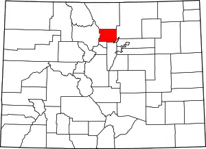 Map of Colorado highlighting Boulder County | |
| Towns | ||
| CDPs | ||
| Unincorporated communities | ||
| Ghost towns |
| |
| Footnotes | ‡This populated place also has portions in an adjacent county or counties | |
| ||
