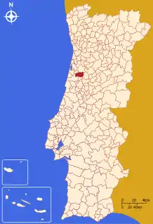
Anadia, Portugal
Anadia (Portuguese pronunciation: [ɐnɐˈði.ɐ] (![]() listen)) is a municipality in Portugal. The population in 2011 was 29,150,[1] in an area of 216.63 km².[2] It had 26,915 eligible voters. The city of Anadia is part of Arcos e Mogofores parish. The city itself had a population of 3,034 in 2001,[3] while Arcos e Mogofores parish has about 5,000.
listen)) is a municipality in Portugal. The population in 2011 was 29,150,[1] in an area of 216.63 km².[2] It had 26,915 eligible voters. The city of Anadia is part of Arcos e Mogofores parish. The city itself had a population of 3,034 in 2001,[3] while Arcos e Mogofores parish has about 5,000.
Anadia | |
|---|---|
.jpg.webp) | |
 Flag  Coat of arms | |
 | |
| Coordinates: 40°26′27″N 8°26′6″W | |
| Country | |
| Region | Centro |
| Intermunic. comm. | Região de Aveiro |
| District | Aveiro |
| Parishes | 10 |
| Government | |
| • President | Litério Augusto Marques (PSD) |
| Area | |
| • Total | 216.63 km2 (83.64 sq mi) |
| Elevation | 49 m (161 ft) |
| Population (2011) | |
| • Total | 29,150 |
| • Density | 130/km2 (350/sq mi) |
| Time zone | UTC±00:00 (WET) |
| • Summer (DST) | UTC+01:00 (WEST) |
| Postal code | 3780 |
| Area code | 231 |
| Patron | São Paio |
| Website | http://www.cm-anadia.pt/ |
History
The history of the municipality is poorly documented before the Roman era, although some vestiges of early Paleolithic (Monte Crasto, Carvalhais and Vila Nova de Monsarros), Neolithic (Moita) and Iron Age (Monte Crasto) artifacts have been studied in this area. But remnants of Roman era artifacts have been isolated in many parts of the municipality, including Aguim, Avelãs de Caminho, Avelãs de Cima, Mogofores, Moita, Óis do Bairro, São Lourenço do Bairro, Vila Nova de Monsarros, Vilarinho do Bairro and, especially, in Anadia (Monte Crasto) and Sangalhos. In addition to domestic ceramic evidence, this early villages in this area existed along the cross roads between the major Roman towns of the time: Olissipo (Lisbon) and Cale (Porto). This continues to be a source of investigation and theories as to the local importance.
Although there may have existed organized communities during this period, it was only during the Medieval Age when documentation began to appear. As such, the villages of São Lourenço do Bairro (883), Arcos (943), Sangalhos (957), Vila Nova de Monsarros (1006), Levira (1020), Vilarinho do Bairro (1020), Samel (1020), Monsarros (1064), Moita (1064),[4] Tamengos (1064), Horta (1064), Anadia (1082), Quintela (1082), Óis do Bairro (1086), Aguim (1101), Mata (1131), Avelãs de Baixo (1132), Figueira (1138), Ferreiros (1138), Ancas (1143), Mogofores (1143), Sá (1143) and Paredes do Bairro (1143), where documented in local land registries and referenced in court records.
With about five centuries of populational existence, the area of Anadia developed over successive mutations in administrative domain. The region, during its formative age, was not developed from the implementation of forals as was the traditional method of instituting land development. But, in the historical Aveiro district on three forals were instituted to promote development: Ferreiros, Fontemanha and Vale de Avim (centers that were part of the older parish of Moita). There have been posterior references to forals conceded in this area (in Avelãs de Caminho, for example), but they were insufficiently explained to indicate that the forals were more than mere local or defensive contracts between the Crown and/or the peoples of the area. Further, there were erroneous references to older forals by contemporary authors, in particular case, the municipalities of Aguim and Anadia. At the beginning of the 16th century, during the administrative reforms of King Manuel I, the king did not forget the coastal central region, and allocated several forals. In 1514, the municipalities of Anadia, Avelãs de Cima, Vilarinho do Bairro, Carvalhais (which included Ferreiros, Fontemanha and Vale de Avim), São Lourenço do Bairro, Aguim, Sangalhos, Pereiro (the parish of Avelãs de Cima), Óis do Bairro, Mogofores, Avelãs de Caminho, Boialvo (parish of Avelãs de Cima) and Vila Nova de Monsarros; in 1519 Paredes do Bairro was granted a writ and then in 1520 forals for Mogofores and Óis do Bairro were established.
Geography and Climate
The municipality of Anadia is located in the Beira Litoral area of the Centro Region, in an area of the Baixo Vouga referred to as the Bairrada, an area traditionally representative of the district of Aveiro. Anadia is situated geographically between the municipalities of Águeda and Oliveira do Bairro (in the north), Mealhada (to the south) and bordered by the municipal borders of Cantanhede (in the west) and Mortágua (in the east).
Climate
| Climate data for Anadia, 1971-2000 normals and extremes | |||||||||||||
|---|---|---|---|---|---|---|---|---|---|---|---|---|---|
| Month | Jan | Feb | Mar | Apr | May | Jun | Jul | Aug | Sep | Oct | Nov | Dec | Year |
| Record high °C (°F) | 21.6 (70.9) |
24.5 (76.1) |
28.5 (83.3) |
31.5 (88.7) |
35.0 (95.0) |
41.0 (105.8) |
40.5 (104.9) |
40.6 (105.1) |
40.6 (105.1) |
32.5 (90.5) |
27.5 (81.5) |
25.0 (77.0) |
41.0 (105.8) |
| Average high °C (°F) | 14.2 (57.6) |
15.5 (59.9) |
17.7 (63.9) |
18.8 (65.8) |
21.1 (70.0) |
25.0 (77.0) |
27.7 (81.9) |
27.9 (82.2) |
26.3 (79.3) |
22.0 (71.6) |
17.7 (63.9) |
15.0 (59.0) |
20.7 (69.3) |
| Daily mean °C (°F) | 9.3 (48.7) |
10.5 (50.9) |
12.1 (53.8) |
13.3 (55.9) |
15.8 (60.4) |
19.1 (66.4) |
21.3 (70.3) |
21.2 (70.2) |
19.7 (67.5) |
16.3 (61.3) |
12.5 (54.5) |
10.6 (51.1) |
15.1 (59.3) |
| Average low °C (°F) | 4.3 (39.7) |
5.4 (41.7) |
6.4 (43.5) |
7.8 (46.0) |
10.4 (50.7) |
13.3 (55.9) |
14.9 (58.8) |
14.5 (58.1) |
13.3 (55.9) |
10.7 (51.3) |
7.5 (45.5) |
6.2 (43.2) |
9.6 (49.2) |
| Record low °C (°F) | −5.5 (22.1) |
−5 (23) |
−4.5 (23.9) |
−2.0 (28.4) |
0.5 (32.9) |
4.5 (40.1) |
7.2 (45.0) |
6.0 (42.8) |
2.0 (35.6) |
−2.0 (28.4) |
−3.5 (25.7) |
−3.6 (25.5) |
−5.5 (22.1) |
| Average rainfall mm (inches) | 131.1 (5.16) |
125.5 (4.94) |
79.3 (3.12) |
101.2 (3.98) |
81.4 (3.20) |
40.4 (1.59) |
12.9 (0.51) |
16.3 (0.64) |
51.1 (2.01) |
109.6 (4.31) |
111.8 (4.40) |
151.2 (5.95) |
1,011.8 (39.81) |
| Average precipitation days (≥ 0.1 mm) | 14.2 | 14.1 | 11.5 | 13.0 | 11.5 | 7.0 | 3.3 | 3.3 | 7.7 | 12.2 | 12.1 | 13.4 | 123.3 |
| Source: Instituto de Meteorologia[5] | |||||||||||||
Human geography
Anadia is in the heart of Bairrada, a fertile agricultural and viticulture area, which has recently stagnated in terms of population. Anadia municipality has one city: Anadia (which is in the parish of Arcos) and one town: Sangalhos. Curia, a village in Tamengos parish is a popular tourist spa with hotels, restaurants and a park with a lagoon.
|
Administratively, the municipality is divided into 10 civil parishes (freguesias):[6]
- Amoreira da Gândara, Paredes do Bairro e Ancas
- Arcos e Mogofores
- Avelãs de Caminho
- Avelãs de Cima
- Moita
- Sangalhos
- São Lourenço do Bairro
- Tamengos, Aguim e Óis do Bairro
- Vila Nova de Monsarros
- Vilarinho do Bairro
See also
References
- Notes
- Instituto Nacional de Estatística
- "Áreas das freguesias, concelhos, distritos e país". Archived from the original on 2018-11-05. Retrieved 2018-11-05.
- Soares, Nuno Pires (2004). "Uma População que se Urbaniza, Uma Avaliação Recente: Cidades, 2004" (in Portuguese). Lisbon, Portugal: Instituto Geográfico Português. Archived from the original on 2014-10-06.
- Referring to the existence of the Church of São Cucufate
- "Monthly Averages for Anadia (1971–2000)" (PDF). Instituto de Meteorologia.
- Diário da República. "Law nr. 11-A/2013, page 552 15" (pdf) (in Portuguese). Retrieved 16 July 2014.
- Sources
- Rosmaninho, Nuno (2001). Anadia: Relance histórico, artístico e etnográfico [Anadia: An Overview of the History, Art and Ethonography] (in Portuguese). Paredes, Portugal: Reviver Editora.