Anano River
Anano River (穴の川, Ana-no-kawa) is a river located in the Minami-ku Ishiyama area of southern Sapporo in Hokkaidō, Japan.[1] It is a tributary of the Toyohira River[2] and classified as class A river.[3] It is 9.4 km long and has a catchment area of 8.9 km2.[4]
| Anano River 穴の川 | |
|---|---|
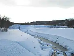 View to the south from the Ananokawa Bridge (December 2004) | |
| Native name | Ana-no-kawa |
| Location | |
| Country | Japan |
| State | Hokkaidō |
| Region | Isikari |
| District | Sapporo |
| Municipality | Sapporo |
| Physical characteristics | |
| Source | Ishiyama area, Minami-ku |
| • location | Sapporo, Hokkaidō, Japan |
| • coordinates | 42°56′1″N 141°19′44″E |
| Mouth | Toyohira River |
• location | Sapporo, Hokkaidō, Japan |
• coordinates | 42°58′1″N 141°19′55″E |
| Length | 9.4 km (5.8 mi) |
| Basin size | 8.9 km2 (3.4 sq mi) |
Engineering
The Sapporo River Work Office built a sand control dam on the Anano River with a sand-retarding basin.[4]
References
- 環境省補助事業 穴の川環境整備事業 (in Japanese). 札幌市役所. Archived from the original on 25 September 2012. Retrieved 16 July 2010.
- 地図閲覧サービス 2万5千分1地形図名: 石山(札幌) (in Japanese). Geospatial Information Authority. Retrieved 16 July 2010.
- 札幌市の河川区分 (in Japanese). 札幌市役所. Retrieved 16 July 2010.
- "Seeking the Richness of Tomorrow in the Flow of Rivers" (PDF). Sapporo River Work Office. Retrieved 16 July 2010.
| |||||||||||||||
| |||||||||||||||
| |||||||||||||||
| |||||||||||||||
| |||||||||||||||
This article is issued from Wikipedia. The text is licensed under Creative Commons - Attribution - Sharealike. Additional terms may apply for the media files.