Agano River
The Agano River (阿賀野川, Agano-gawa) is a river in the Hokuriku region of Honshu, Japan. It is also called the Aga River or the Ōkawa River in Fukushima.
| Agano River | |
|---|---|
 | |
| Native name | 阿賀野川 |
| Location | |
| Country | Japan |
| Physical characteristics | |
| Source | |
| • location | Mount Arakai, border of Fukushima Prefecture and Tochigi Prefecture |
| • elevation | 1,581 m (5,187 ft) |
| Mouth | |
• location | Sea of Japan, Niigata Prefecture |
• coordinates | 37°57′48″N 139°07′46″E |
• elevation | 0 m (0 ft) |
| Length | 210 km (130 mi) |
| Basin size | 7,710 km2 (2,980 sq mi) |
| Discharge | |
| • average | 451 m3/s (15,900 cu ft/s) |
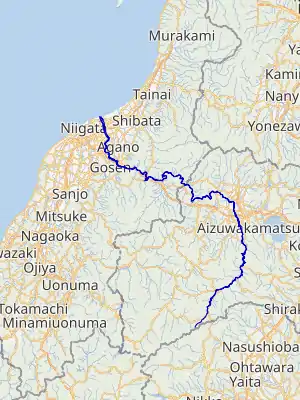
The source of the river is Mount Arakai on the border of Fukushima and Tochigi. It flows to the north and meets the Nippashi River from Lake Inawashiro and the Tadami River in the Aizu Basin, and then turns to the west and falls into the Sea of Japan. The Agano River flows for 210 kilometers. It has a watershed area of 7,710 square kilometers.[1]
In 1964–1965, a chemical factory at Kanose village in Niigata Prefecture released methylmercury into the river and caused Niigata Minamata disease.[2]
There are several hydroelectric power plants on the Agano River:
- Inawashiro Power Plant (107.5 MW), constructed several steps in 1899–1940. It was the site of the Japan first high-voltage, long-range power transmission line.
- Numazawanuma Power Plant (43.7 MW), constructed in 1952.[3] It was the first pumped-storage power plant in Japan.
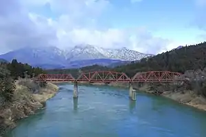
.jpg.webp) Agano River near Kitakata
Agano River near Kitakata
References
- "Agano River". Tourist Link. Retrieved 4 March 2013.
- Ceccatelli, Sandra; Aschner, Michael (23 March 2012). Methylmercury and Neurotoxicity. Springer Science & Business Media. p. 5. ISBN 978-1-4614-2382-9.
- Simeons, Charles (24 April 2014). Hydro-Power: The Use of Water as an Alternative Source of Energy. Elsevier Science. p. 510. ISBN 978-1-4831-4561-7.
External links
 Media related to Agano River at Wikimedia Commons
| |||||||||||||||
| |||||||||||||||
| |||||||||||||||
| |||||||||||||||
| |||||||||||||||
| Authority control |
|---|
This article is issued from Wikipedia. The text is licensed under Creative Commons - Attribution - Sharealike. Additional terms may apply for the media files.