Jōganji River
The Jōganji River (常願寺川, Jōganji-gawa) is a river in Toyama Prefecture, Japan, that flows through the city of Toyama as well as the town of Tateyama. The river was previously referred to as the Nii River (新川 Nii-kawa).[1]
| Jōganji River 常願寺川 | |
|---|---|
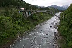 The Jōganji River flowing through the city of Toyama | |
| Location | |
| Country | Japan |
| Physical characteristics | |
| Source | |
| • location | Mount Kitanomata |
| • elevation | 2,661 m (8,730 ft) |
| Mouth | |
• location | Toyama Bay |
| Length | 56 km (35 mi) |
| Basin size | 368 km2 (142 sq mi) |
| Discharge | |
| • average | 15 m3/s (530 cu ft/s) |
| Basin features | |
| River system | Jōganji River |
Route
The river originates in the Tateyama Mountains in the south-eastern area of the city of Toyama. From there, it flows north-west, helping form the border between Toyama and Tateyama. It then cuts through Toyama before emptying into Toyama Bay.[1]
References
- "Jōganji River Japan Tourist Information". Touristlink.com. Retrieved 2013-11-02.
| |||||||||||||||
| |||||||||||||||
| |||||||||||||||
| |||||||||||||||
| |||||||||||||||
| Authority control |
|---|
This article is issued from Wikipedia. The text is licensed under Creative Commons - Attribution - Sharealike. Additional terms may apply for the media files.