Yoneshiro River
The Yoneshiro River (米代川, Yoneshirogawa) is a river in Tōhoku region of the northern portion of the island of Honshū in Japan. It is 136 kilometres (85 mi) long and has a watershed of 4,100 square kilometres (1,600 sq mi).[1]
| Yoneshiro River | |
|---|---|
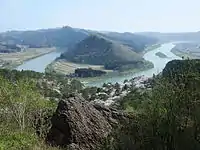 View of the Yoneshiro River From Mt. Nanakura, in Noshiro, Akita | |
| Native name | Japanese: 米代川 |
| Location | |
| Country | Japan |
| Physical characteristics | |
| Source | |
| • location | Ōu Mountains, Akita and Iwate Prefectures |
| • elevation | 1,024 m (3,360 ft) |
| Mouth | |
• location | Sea of Japan |
• elevation | 0 m (0 ft) |
| Length | 136 km (85 mi) |
| Basin size | 4,100 km2 (1,600 sq mi) |
| Discharge | |
| • average | 254 m3/s (9,000 cu ft/s) |
The river rises from Mount Nakadake and Mount Shikakudake in the Ōu Mountains and Mount Hachimantai near the border of Akita Prefecture with Iwate and Aomori Prefectures, and flows to the west through northern Akita Prefecture into the Sea of Japan at Noshiro, Akita.
References
- "Yoneshirogawa" (in Japanese). Ministry of Land, Infrastructure and Tourism. 2007. Retrieved 20 February 2016.
| |||||||||||||||
| |||||||||||||||
| |||||||||||||||
| |||||||||||||||
| |||||||||||||||
This article is issued from Wikipedia. The text is licensed under Creative Commons - Attribution - Sharealike. Additional terms may apply for the media files.