Anerley railway station
Anerley railway station is in the London Borough of Bromley in south London. The station is operated by London Overground, with Overground and Southern trains serving the station. It is 7 miles 47 chains (12.21 km) down the line from London Bridge, in Travelcard Zone 4.
| Anerley | |
|---|---|
 | |
 Anerley Location of Anerley in Greater London | |
| Location | Anerley |
| Local authority | London Borough of Bromley |
| Managed by | London Overground |
| Owner | Network Rail |
| Station code | ANZ |
| DfT category | E |
| Number of platforms | 2 |
| Accessible | Yes[1] |
| Fare zone | 4 |
| National Rail annual entry and exit | |
| 2015–16 | |
| 2016–17 | |
| 2017–18 | |
| 2018–19 | |
| 2019–20 | |
| Key dates | |
| 5 June 1839 | Station opened as Anerley Bridge |
| 1840 | Station renamed Anerley |
| Other information | |
| External links | |
| WGS84 | 51.4147°N 0.067°W |
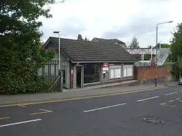
The main building on the down side (which is only open weekday/Saturday mornings) replaced an original building which was on the up platform. This was in turn replaced by two shelters on the Up platform. There is a bridge connecting the two platforms. Four lines run through the station, the central pair being the Up and Down through lines. The station stands off Anerley Road (A214).
History
The station was opened originally as Anerley Bridge by the London and Croydon Railway in 1839.[3][4] It was situated in a largely unpopulated area, but was built as part of an agreement with the local landowner.[5]
According to local lore, the landowner was a Scotsman and, when asked for the landmark by which the station would be known, he replied "Mine is the annerly hoose". The timetable of the day seems to back this up since it says "There is no place of that name".[6]
The London and Croydon Railway amalgamated with the London and Brighton Railway to form the London, Brighton and South Coast Railway in July 1846, and the station was rebuilt during the widening of the main line during 1849/50.[7]
During the Grouping of 1923 the station became part of the Southern Railway, and then passed on to the Southern Region of British Railways on nationalisation in 1948.
When Sectorisation was introduced in the 1980s, the station was served by Network SouthEast until the Privatisation of British Rail.
Anerley formed part of the new southward extension to the East London line that opened on 23 May 2010, making Anerley part of the London Overground network. At the same time, management of the station passed from Southern to London Overground.
Services

London Overground
As of December 2012 the off peak frequency is:[8]
- 4tph Northbound to Highbury & Islington
- 4tph Southbound to West Croydon
Southern
As of May 2018 the off peak frequency is:[9]
- 2tph Northbound to London Bridge
- 2tph Southbound to Coulsdon Town
During peak periods, additional Southbound trains may terminate at Sutton or West Croydon. On Sundays, southbound services are usually extended to Caterham.
Connections
London Buses routes 157, 249, 354, 358, 432 and night route N3 serve the station.[10]
Lines
| Preceding station | Following station | |||
|---|---|---|---|---|
towards Highbury & Islington | East London Line | towards West Croydon |
||
| Penge West | Southern Brighton main line |
Norwood Junction | ||
References
- "London and South East" (PDF). National Rail. September 2006. Archived from the original (PDF) on 6 March 2009.
- "Station usage estimates". Rail statistics. Office of Rail Regulation. Please note: Some methodology may vary year on year.
- Borley, H.V. Chronology of London Railways.
- Connor, J.E.; Halford, B. Forgotten Stations of Greater London.
- Turner, John Howard (1978). The London Brighton and South Coast Railway 1 Origins and Formation. Batsford. p. 51. ISBN 0-7134-0275-X.
- Warwick, Alan (1972). The Phoenix Suburb: a South London social history. Blue Boar Press. ISBN 0904034003.
- Turner, John Howard (1978). The London Brighton and South Coast Railway 2 Establishment and Growth. Batsford. p. 48. ISBN 0-7134-1198-8.
- "Overground timetables". TfL. Archived from the original on 17 December 2012. Retrieved 9 December 2012.
- "Timetables: Table 42". Southern. Archived from the original on 15 September 2018. Retrieved 9 September 2018.
- "Buses from Anerley Station" (PDF). TfL. 15 July 2017. Retrieved 2 June 2020.
Sources
- Butt, R. V. J. (1995). The Directory of Railway Stations: details every public and private passenger station, halt, platform and stopping place, past and present (1st ed.). Sparkford: Patrick Stephens Ltd. ISBN 978-1-85260-508-7. OCLC 60251199.
- Jowett, Alan (2000). Jowett's Nationalised Railway Atlas (1st ed.). Penryn, Cornwall: Atlantic Transport Publishers. ISBN 978-0-906899-99-1. OCLC 228266687.
External links
| Wikimedia Commons has media related to Anerley railway station. |
- Train times and station information for Anerley railway station from National Rail
- Anerley on the London Overground map
| Companies and organisations |
| ||||||||||
|---|---|---|---|---|---|---|---|---|---|---|---|
| Airports |
| ||||||||||
| Major stations |
| ||||||||||
| Roads |
| ||||||||||
| Ticketing | |||||||||||
| Other | |||||||||||
| Former BR sectors | |||||||||||
| |||||||||||
| |||||||||||||||||||||
| |||||||||||||||||||||