Anglards-de-Salers
Anglards-de-Salers is a commune in the Cantal department in the Auvergne region of south-central France.
Anglards-de-Salers | |
|---|---|
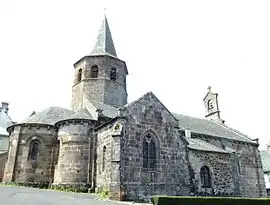 The church of Saint-Thyrse, in Anglards-de-Salers | |
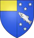 Coat of arms | |
Location of Anglards-de-Salers 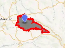
| |
 Anglards-de-Salers  Anglards-de-Salers | |
| Coordinates: 45°12′20″N 2°26′27″E | |
| Country | France |
| Region | Auvergne-Rhône-Alpes |
| Department | Cantal |
| Arrondissement | Mauriac |
| Canton | Mauriac |
| Intercommunality | Pays de Salers |
| Government | |
| • Mayor (2014-2020) | François Descoeur |
| Area 1 | 48.36 km2 (18.67 sq mi) |
| Population (2017-01-01)[1] | 777 |
| • Density | 16/km2 (42/sq mi) |
| Time zone | UTC+01:00 (CET) |
| • Summer (DST) | UTC+02:00 (CEST) |
| INSEE/Postal code | 15006 /15380 |
| Elevation | 530–1,317 m (1,739–4,321 ft) (avg. 825 m or 2,707 ft) |
| 1 French Land Register data, which excludes lakes, ponds, glaciers > 1 km2 (0.386 sq mi or 247 acres) and river estuaries. | |
The inhabitants of the commune are known as Anglardois or Anglardoises[2]
Geography
Anglards-de-Salers is located some 60 km west by north-west of Saint-Flour and 15 km south of Ydes. It can be accessed by the D122 road from Mauriac in the west to the village. There is also the minor D22 road from Méallet in the north to the village which continues as a more major road to Salers in the south-east. The D222 road also comes to the village from Salins in the west. The D12 road from Veyrieres in the north also passes inside the north-eastern border of the commune and continues to Le Falgoux to the south-east of the commune. The D212 roads goes west from the D12 to the village. There are a number of small hamlets in the commune. These are:
- Les Aldieres
- Bagnac
- Baliergues
- La Bastide
- Bouisse
- Le Breuil
- Le Caire
- Le Chambon
- Chapsieres
- Epinasolles
- Fignac
- Fournols
- Haut Bagnac
- Joncoux
- Longvergne
- Maleprade
- Montclard
- Noux
- Nuzerolles
- Le Peil
- Pepanie
- Pons
- Pradelles
- Sarrette
- Le Viaureau
- Voleyrac
Other than a belt of forest along the north of the commune, the commune is entirely farmland.
The Mars stream flows through the north of the commune from the east joined by the Ruisseau de Veysset in the north of the commune then continuing north to join the Sumene at Vendes. There is also the Auze stream flowing through the heart of the commune towards the west where it joins the Sione east of Escorailles. The Monzola also flows west in the south joining the Auze just west of the commune. Several other unnamed streams flow into these streams.[3]
Neighbouring communes and villages
Places adjacent to Anglards-de-Salers | ||||||||||
|---|---|---|---|---|---|---|---|---|---|---|
| ||||||||||
History
List of Priests for Anglards-de-Salers
List of Priests
| From | To | Name | Title |
|---|---|---|---|
| 1508 | Jean de Chazettes | Curato Eclesiae parrochialis anglaris | |
| 1919 | 1929 | A. Borne | Priest |
| 1936 | 1941 | Paul Besse | Priest |
(Not all data is known)
Heraldry
Arms of Anglards-de-Salers |
The official status of the blazon is to be determined
Blazon: |
Administration
List of Successive Mayors[4]
| From | To | Name | Party | Position |
|---|---|---|---|---|
| 1792 | 1800 | Antoine Faucher | Notary | |
| 1800 | 1803 | Jean Pebrel | ||
| 1803 | 1808 | Antoine Bergeron | ||
| 1808 | 1825 | Jean Antoine Sauvage | ||
| 1825 | 1830 | Jean Rolland | ||
| 1848 | 1860 | Jean-Martin Salsac | ||
| 1904 | 1908 | Justin Mourguy | ||
| 1908 | 1919 | Paul Bergeron | Doctor | |
| 1920 | 1935 | Antoine Serre | ||
| 1935 | 1947 | Joseph Mathieu | Doctor | |
| 1947 | 1965 | Augustin Chauvet | UDSR | |
| 1965 | 1995 | Jean Descoeur | Doctor | |
| 1995 | Current | François Descoeur | DVD | Architect |
(Not all data is known)
Population
| Year | Pop. | ±% |
|---|---|---|
| 2005 | 772 | — |
| 2006 | 765 | −0.9% |
| 2007 | 767 | +0.3% |
| 2008 | 783 | +2.1% |
| 2009 | 799 | +2.0% |
| 2010 | 815 | +2.0% |
| 2011 | 817 | +0.2% |
| 2012 | 809 | −1.0% |
| 2013 | 802 | −0.9% |
| 2014 | 795 | −0.9% |
| 2015 | 788 | −0.9% |
| 2016 | 781 | −0.9% |
Culture and heritage
Civil heritage
The commune has a number of buildings and structures that are registered as historical monuments:
- The Espradel Garden (19th century)
 [5]
[5] - The Chateau de Longevergne (1905)[6]
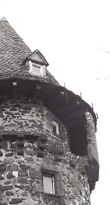
- The Château de la Trémolière (15th century)[7] The chateau houses a collection of Aubusson tapestries from the 16th century called the "bestiaire fantastique" (fantastic bestiary). The Chateau contains two items that are registered as historical objects:
- The Montbrun Garden[10]
- Other sites of interest
- The Deduit Orchard is a creation by landscapers Ossart and Maurières:[11] a contemporary medieval garden inspired by the Roman de la rose and the bestiaire fantastique collection.
- Walking trails in the mountain pastures with a plan table
- Robert Besogne Stadium is a football stadium hosting the EAS (Entente Anglards Salers)
Notable people linked to the commune
- Paul Malassagne, Senator for Cantal, was born at Nuzerolles
See also
External links
Notes and references
Notes
References
- "Populations légales 2017". INSEE. Retrieved 6 January 2020.
- Inhabitants of Cantal (in French)
- Google Maps
- List of Mayors of France
- Ministry of Culture, Mérimée IA15000332 Espradel Garden (in French)
- Ministry of Culture, Mérimée PA15000015 Chateau de Longevergne (in French)
- Ministry of Culture, Mérimée PA00093438 Château de la Trémolière (in French)

- Ministry of Culture, Palissy PM15000046 4 sets of Wood Panelling (in French)
- Ministry of Culture, Palissy PM15000044 11 Tapestries (in French)
- Ministry of Culture, Mérimée IA15000387 Montbrun Garden (in French)
- Deduit Orchard Official website (in French)
- Ministry of Culture, Mérimée PA00093439 Church of Saint-Thyrse (in French)
- Ministry of Culture, Palissy PM15000043 Face of the Altar: Descent from the Cross (in French)
- Ministry of Culture, Palissy PM15000045 Group Sculpture: Virgin of Pity (in French)
| Wikimedia Commons has media related to Anglards-de-Salers. |
| Authority control |
|---|