Apchon
Apchon is a commune in the Cantal department in the Auvergne region of south-central France.
Apchon | |
|---|---|
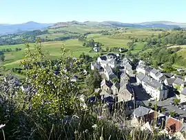 A general view of Apchon, seen from the château | |
 Coat of arms | |
Location of Apchon 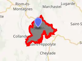
| |
 Apchon  Apchon | |
| Coordinates: 45°15′00″N 2°41′41″E | |
| Country | France |
| Region | Auvergne-Rhône-Alpes |
| Department | Cantal |
| Arrondissement | Mauriac |
| Canton | Riom-ès-Montagnes |
| Intercommunality | Pays Gentiane |
| Government | |
| • Mayor (2014-2020) | Pierre Pouget |
| Area 1 | 12.43 km2 (4.80 sq mi) |
| Population (2017-01-01)[1] | 186 |
| • Density | 15/km2 (39/sq mi) |
| Time zone | UTC+01:00 (CET) |
| • Summer (DST) | UTC+02:00 (CEST) |
| INSEE/Postal code | 15009 /15400 |
| Elevation | 833–1,143 m (2,733–3,750 ft) (avg. 1,060 m or 3,480 ft) |
| 1 French Land Register data, which excludes lakes, ponds, glaciers > 1 km2 (0.386 sq mi or 247 acres) and river estuaries. | |
The inhabitants of the commune are known as Apchonnais or Apchonnaises.[2]
Geography
Apchon is located some 80 km south-west of Clermont-Ferrand, 25 km north-west of Murat, and 30 km south-east of Bort-les-Orgues. Access is by the D3 road from Riom-ès-Montagnes in the north-west passing through the north of the commune to Murat in the south-east. Access to the village is by the D49 which branches off the D3 north-east of the commune and passes through the village then south to Saint-Hippolyte. There is also the D249 from the village south-west to join the D263 south of Collandres. Apart from the village there are also the hamlets of La Ribeyre and La Vidal along the D3, and Brechailles on the north-east. Apart from some patches of forest in the north the commune is entirely farmland.
The Petite Rhue river flows from south to north through the commune and continues to join the Grande Rhue river at Coindre. The Ruisseau de Brechailles flows from the south-east to join the Petite Rhue north of the D3. The Ruisseau de Mazeyres rises in the south of the commune and flows into the Petite Rhue on the left bank. Several small streams rise in the west of the commune and flow north-west eventually joining and flowing into the Veronne.[3]
Neighbouring communes and villages
Places adjacent to Apchon | ||||||||||
|---|---|---|---|---|---|---|---|---|---|---|
| ||||||||||
Heraldry
Arms of Apchon |
The official status of the blazon remains to be determined.
Blazon: |
Administration
List of successive mayors[4]
| From | To | Name | Party | Position |
|---|---|---|---|---|
| 2001 | Current | Pierre Pouget |
(Not all data is known.)
Population
| Year | Pop. | ±% |
|---|---|---|
| 2005 | 215 | — |
| 2006 | 208 | −3.3% |
| 2007 | 207 | −0.5% |
| 2008 | 209 | +1.0% |
| 2009 | 210 | +0.5% |
| 2010 | 212 | +1.0% |
| 2011 | 209 | −1.4% |
| 2012 | 205 | −1.9% |
| 2013 | 199 | −2.9% |
| 2014 | 194 | −2.5% |
| 2015 | 188 | −3.1% |
| 2016 | 187 | −0.5% |
Sites and monuments
The Château fort d'Apchon (12th century)![]() is registered as an historical monument.[5]
is registered as an historical monument.[5]
The Church contains several items that are registered as historical objects:
- An Altar, Retable, and Statue (17th century)
 [6]
[6] - An Altar, Retable, 2 Statues, and a Bust-Reliquary (17th century)[7]
- An Altar, Retable, and 2 Group Sculptures (17th century)[8]
- A Statue: Virgin and child (15th century)[9]
- A Retable in the main Altar (18th century)[10]
- 2 Sarcophagii (11th century)[11]
Views of Apchon
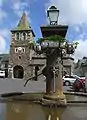 Parish church
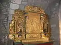 Church interior
 Ruins of the castle (built between 1408 and 1422)
- View of the village from the castle
See also
External links
- Apchon on the National Geographic Institute website (in French)
- Apchon on Lion1906
- Apchon on Géoportail, National Geographic Institute (IGN) website (in French)
- Apchon on the 1750 Cassini Map
Notes and references
Notes
References
- "Populations légales 2017". INSEE. Retrieved 6 January 2020.
- Inhabitants of Cantal (in French)
- Google Maps
- List of Mayors of France
- Ministry of Culture, Mérimée PA15000047 Château fort d'Apchon (in French)
- Ministry of Culture, Palissy PM15000056 Altar, Retable, and Statue (in French)

- Ministry of Culture, Palissy PM15000055 Altar, Retable, 2 Statues, and a Bust-Reliquary (in French)
- Ministry of Culture, Palissy PM15000054 Altar, Retable, and 2 Group Sculptures (in French)
- Ministry of Culture, Palissy PM15000053 Statue: Virgin and child (in French)
- Ministry of Culture, Palissy PM15000052 Retable in the main Altar (in French)
- Ministry of Culture, Palissy PM15000051 2 Sarcophagii (in French)
| Wikimedia Commons has media related to Apchon. |
| Authority control |
|
|---|