Chanterelle, Cantal
Chanterelle is a commune in the Cantal department in south-central France.
Chanterelle | |
|---|---|
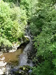 The Rhue river in Chanterelle | |
Location of Chanterelle 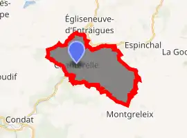
| |
 Chanterelle  Chanterelle | |
| Coordinates: 45°22′50″N 2°48′53″E | |
| Country | France |
| Region | Auvergne-Rhône-Alpes |
| Department | Cantal |
| Arrondissement | Saint-Flour |
| Canton | Riom-ès-Montagnes |
| Government | |
| • Mayor (2008–2014) | Maurice Pallut |
| Area 1 | 19.72 km2 (7.61 sq mi) |
| Population (2017-01-01)[1] | 95 |
| • Density | 4.8/km2 (12/sq mi) |
| Time zone | UTC+01:00 (CET) |
| • Summer (DST) | UTC+02:00 (CEST) |
| INSEE/Postal code | 15040 /15190 |
| Elevation | 800–1,225 m (2,625–4,019 ft) (avg. 1,000 m or 3,300 ft) |
| 1 French Land Register data, which excludes lakes, ponds, glaciers > 1 km2 (0.386 sq mi or 247 acres) and river estuaries. | |
Geography
The river Rhue flows southwest through the western part of the commune.
Population
| Year | Pop. | ±% |
|---|---|---|
| 1962 | 271 | — |
| 1968 | 307 | +13.3% |
| 1975 | 227 | −26.1% |
| 1982 | 161 | −29.1% |
| 1990 | 165 | +2.5% |
| 1999 | 150 | −9.1% |
| 2008 | 139 | −7.3% |
See also
References
- "Populations légales 2017". INSEE. Retrieved 6 January 2020.
| Wikimedia Commons has media related to Chanterelle (Cantal). |
| Authority control |
|
|---|
This article is issued from Wikipedia. The text is licensed under Creative Commons - Attribution - Sharealike. Additional terms may apply for the media files.