Aoukar
Aoukar or Erg Aoukar[1] (Arabic: عوكر) is a geological depression area of south eastern Mauritania. It is located between Kiffa and Néma, south of the Tagant Plateau.
Aoukar
عوكر | |
|---|---|
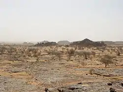 Landscape in the Ayoun el Atrous area | |
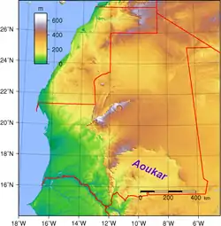 Location of the Aoukar basin in Mauritania | |
| Country | Mauritania |
| Elevation | 240 m (790 ft) |
The Aoukar basin is a dry natural region of sand dunes and salt pans fringed by escarpments on its northern and eastern sides.
History
There was once vast reed-covered endorheic lake in the area, but it no longer exists. Between about 1700 BC and 400 BC a civilization developed around its shores. The former lake of Aoukar extended towards the area of Tichit, bordering the southern edge of the Tagant Plateau.
Below the cliffs (dhars) facing the extinct lake remains of about 400 villages have been found.[2][3]
Ecology
The Aoukar is one of the few natural refuges for the addax, a critically endangered kind of antelope which lives in the region.[4]
See also
References
- Marco Stoppato, Alfredo Bini (2003), Deserts, p. 156
- Tichit - The living ghost of yesterday's glory
- G. Marcus and B. de Valicourt (2000). Mauritanie, p. 10
- Richard Trillo, The Rough Guide to West Africa