Somali Plate
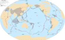
The Somali Plate is a minor tectonic plate which straddles the Equator in the Eastern Hemisphere. It is approximately centered on the island of Madagascar and includes about half of the east coast of Africa, from the Gulf of Aden in the north through the East African Rift Valley. The southern boundary with the Nubian-African Plate is a diffuse plate boundary consisting of the Lwandle Plate.[2]
| Somali Plate | |
|---|---|
 | |
| Type | Minor |
| Approximate area | 16,700,000 km2[1] |
| Movement1 | south-east |
| Speed1 | 6 mm/year |
| Features | East Africa, Madagascar, Indian Ocean |
| 1Relative to the African Plate | |
Geology
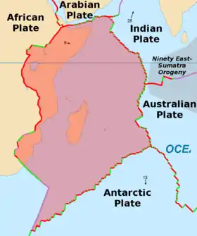
The Arabian Plate diverges to the north forming the Gulf of Aden. The Indian Plate, Australian Plate, and Antarctic Plate all diverge from the Somali Plate forming the eastern Indian Ocean. The Somali-Indian boundary spreading ridge is known as the Carlsberg Ridge. The Somali-Australian boundary spreading ridge is known as the Central Indian Ridge. The Somali-Antarctic boundary spreading ridge is known as the Southwest Indian Ridge. The western boundary with the African Plate is diverging to form the East African Rift, which stretches south from the triple junction in the Afar depression. The southern boundary with the Nubian-African Plate is a diffuse plate boundary with of the Lwandle Plate.[2] The Seychelles and the Mascarene Plateau are located northeast of the Madagascar.
Tectonic history
From 1.4 to 1.2 Ga the Kibaran orogeny fused the Tanzanian and Congo cratons.[3] From 1000 to 600 Ma the super-continent Gondwana was formed and the Pan-African orogeny sutured the Tanzanian and Kalahari cratons.[3] The rifting of Gondwana occurred from 190 Ma to 47 Ma separating Madagascar from the eastern coast of Africa and placing the Seychelles/Mascarene Plateau northeast of Madagascar.[4][5] The rifting of the Red Sea started around 30 million years ago and the first rifting occurred in the northern East African Rift System around 20 million years ago.[6]
See also
References
- Alden, Andrew (2017-03-17) Here Are the Sizes of Tectonic or Lithospheric Plates. thoughtco.com
- Saria, E; Calais, E.; Stamps, D.S.; Delvaux, D.; Hartnady, C.J.H. (20 March 2014). "Present-day Kinematics of the East African Rift". Journal of Geophysical Research: Solid Earth. 119 (4): 3584–3600. Bibcode:2014JGRB..119.3584S. CiteSeerX 10.1.1.723.5337. doi:10.1002/2013JB010901.
- Rogers, J; Santosh, M (2004). Continents and supercontinents (PDF). Oxford: Oxford University Press. p. 723. ISBN 9780195165890.
- Ali, J; Aitchison, C (2008). "Gondwana to Asia: Plate tectonics, paleogeography and the biological connectivity of the Indian sub-continent from the Middle Jurassic through latest Eocene (166–35 Ma)". Earth-Science Reviews. 88 (3–4): 145–166. Bibcode:2008ESRv...88..145A. doi:10.1016/j.earscirev.2008.01.007.
- Plummer, P (1995). "Ages and geological significance of the igneous rocks from Seychelles". Journal of African Earth Sciences. 20 (2): 91–101. Bibcode:1995JAfES..20...91P. doi:10.1016/0899-5362(95)00035-R.
- Chorowicz, Jean (October 2005). "The East African rift system". Journal of African Earth Sciences. 43 (1–3): 379–410. Bibcode:2005JAfES..43..379C. doi:10.1016/j.jafrearsci.2005.07.019.
Further reading
| Wikimedia Commons has media related to Somali tectonic plate. |