Marrah Mountains
The Marrah Mountains or Marra Mountains (Fur, Fugo Marra; Arabic: جبل مرة, Jebel Marra (Sudanese Arabic – “woman mountains” due to the outline of a reclining woman when viewed from the south-east, also known in English as Gimbala) are a range of volcanic peaks in a massif that rises up to 3,042 metres (9,980 ft). They are the highest mountains in Sudan.
| Marrah Mountains | |
|---|---|
| Jebel Marra | |
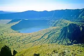 Inner and outer crater, Deriba Crater | |
| Highest point | |
| Peak | Deriba crater |
| Elevation | 3,042 m (9,980 ft) |
| Coordinates | 12°57′00″N 24°16′12″E |
| Geography | |
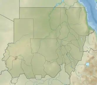 Location in Sudan | |
| Country | Sudan |
| Region | Darfur |
| Geology | |
| Type of rock | Volcanic field |
Geography
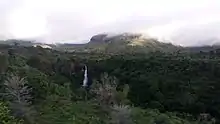
The mountains are located in the center of the Darfur region of Sudan on the border of the states of South Darfur and Central Darfur, with a smaller part of the range in the state of North Darfur. The highest point is Deriba Caldera. The upper reaches of the massif is a small area of temperate climate with high rainfall and permanent springs of water amidst the dry savanna and scrub of the Sahel below.[1]
Apart from the Aïr Mountains in Niger which are on the border of the Sahara proper, the Marrah Mountains are the only major mountain range in the otherwise flat Sahel, rising up to 2,600 metres (8,500 ft) above the plain, but are relatively unknown owing to lack of development and political conflict in the region.
The last eruption occurred around 1500 BC. The centre of activity was Deriba Caldera, and involved caldera collapse following the eruption of pumice and pyroclastic flows which travelled over 30 kilometres (19 mi) from the volcano.[2]
Footnotes
- de Waal, Alex, Famine that Kills: Darfur, Sudan, Oxford University Press (Revised edition), 2005, ISBN 0-19-518163-8, p. 36
- "Jebel Marra: Eruptive History". Global Volcanism Program. Smithsonian Institution.