April 1957 Southeastern United States tornado outbreak
The April 1957 Southeastern United States tornado outbreak struck the southern and southeastern United States during April 7–8, 1957. This outbreak was responsible for producing 7 deaths and 223 injuries across the Southeastern United States.
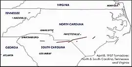 A map of some of the tornadoes that touched down on April 8, 1957. | |
| Type | Tornado outbreak |
|---|---|
| Duration | April 7–8, 1957 |
| Tornadoes confirmed | 19 |
| Max. rating1 | F4 tornado |
| Duration of tornado outbreak2 | ~21 hours |
| Damage | Unknown |
| Casualties | 7 fatalities, 223 injuries |
| Areas affected | Southeastern United States, Nebraska |
Part of the tornado outbreaks of 1957 1Most severe tornado damage; see Fujita scale 2Time from first tornado to last tornado | |
Confirmed tornadoes
| FU | F0 | F1 | F2 | F3 | F4 | F5 | Total |
|---|---|---|---|---|---|---|---|
| 0 | 0 | 3 | 9 | 5 | 2 | 0 | 19 |
April 7 event
| F# | Location | County | State | Time (UTC) | Path length | Damage |
|---|---|---|---|---|---|---|
| F2 | N of Waldron | Scott | AR | 0505 | 4.7 miles (7.6 km) | A tornado damaged three barns and many roofs.[1] The tornado is not listed as significant by tornado researcher Thomas P. Grazulis.[2] |
| F2 | N of Red Bay | Franklin | AL | 0535 | 0.1 miles (0.16 km) | A tornado unroofed one home and ripped off the porches of several others. Barns and garages were destroyed as well.[2] |
April 8 event
| F# | Location | County | State | Time (UTC) | Path length | Damage |
|---|---|---|---|---|---|---|
| F2 | W of Shannon to SW of Verona | Lee | MS | 0910 | 9 miles (14 km) | A tornado destroyed one home.[2] |
| F2 | N of Woody | Cumberland | TN | 1200 | 2.7 miles (4.3 km) | A tornado damaged three barns, five homes, and numerous outbuildings. Trees were uprooted as well.[1] The tornado is not listed as significant by Grazulis.[2] |
| F1 | SE of Bruce | Calhoun | MS | 1400 | 0.1 miles (0.16 km) | A tornado destroyed or badly damaged two homes.[1] |
| F3 | S of Hamilton to N of Piney Grove | Marion, Winston, Lawrence | AL | 1546 | 51.4 miles (82.7 km) | This long-tracked tornado was probably a tornado family. A few small houses were leveled at the end of the path.[2] Trees were damaged along a path up to 1 mi (1.6 km) in width, and a car was carried 0.25 mi (0.40 km).[2] Five people may have been injured, but are not officially counted.[1][2] |
| F3 | NE of Battleground to N of Cottonville | Morgan, Marshall | AL | 1615 | 38.8 miles (62.4 km) | 2 deaths – A tornado hit between Florette and Oleander. Over 150 homes were damaged or destroyed in the small, rural communities of Rock Creek, Lawrence Cove, Briddle Mountain, and Cotaco Valley—all in southern Morgan County.[2] At least 90 (perhaps 125) people were injured.[1][2] |
| F3 | S of Hulaco to NE of Warrenton | Cullman, Morgan, Marshall | AL | 1630 | 16.3 miles (26.2 km) | Numerous, small homes and barns were destroyed. The tornado followed a path similar to that of the preceding tornado.[2] The tornado is rated F2 by Grazulis. |
| F2 | NE of Plainville to NE of Calhoun | Gordon | GA | 1900 | 10.3 miles (16.6 km) | A tornado struck a trailer park, injuring five (perhaps 20) people.[1] 70 buildings were damaged or destroyed.[2] |
| F2 | Cross Keys to S of Santuc | Union | SC | 2100 | 15.2 miles (24.5 km) | A tornado struck near Cross Anchor. Three homes were destroyed and 57 others were damaged. Two people were injured.[1][2] |
| F1 | SE of Chula to Douglas | Tift, Irwin, Coffee | GA | 2100 | 41.3 miles (66.5 km) | One large home lost its roof and others were "shifted." A barn and a lumber mill were destroyed. The tornado was rated F2 by Grazulis.[2] |
| F3 | N of Jacksonville | Telfair | GA | 2130 | 14.7 miles (23.7 km) | 1 death – A truck was thrown 100 ft (30 m), killing the occupant. Two homes and a church were destroyed as well. A refrigerator was thrown 250 yd (750 ft). [2] Three others were injured.[3] |
| F2 | S of Bowmantown | Washington | TN | 2130 | 3 miles (4.8 km) | A grain storage house was unroofed, and 20 large trees were blown down.[1] A barn was shifted 3 feet (1 yd) off its foundation, and flying debris damaged a home.[1] |
| F4 | NE of Heath Springs to Jefferson to Roseboro, North Carolina | Lancaster, Chesterfield, Marlboro, Scotland (NC), Robeson (NC), Cumberland (NC), Sampson (NC) | SC, NC | 2200 | 121.4 miles (195.4 km) | 4 deaths – This was a long-lived tornado family containing at least two separate tornadoes, both of which may have been tornado families themselves. The first (F3) tornado touched down near Flat Creek and moved into the town of Jefferson, tearing apart 23 of 25 buildings on Main Street and destroying or damaging 141 homes and 156 other structures.[2] Continuous damage of F2 and F3 intensity extended from Jefferson to near Cheraw and Wallace. The tornado destroyed or damaged 25 homes in Wallace.[2] Pieces of a cotton gin were carried over 10 mi (16 km). The second (F4) tornado touched down near McColl and crossed into North Carolina near Johns and east of Maxton.[2] A gas station, small homes, and several barns were destroyed.[2] The only F4 damage occurred between Roseboro and Parkersburg, where four people died and about 20 homes were leveled.[2] Well over 397 homes and businesses were damaged or destroyed along the path, including more than 100 in Sampson County alone. In all, 70 people were injured.[4] |
| F1 | SW of Ocean View | Norfolk | VA | 2220 | 1 mile (1.6 km) | This tornado was originally listed as a strong wind in NCDC Storm Data. Two people were injured.[1] |
| F2 | E of Benevolence to N of Brooksville | Randolph | GA | 2330 | 5.2 miles (8.4 km) | Three homes, two barns, and a church were destroyed.[2] One person was injured. |
| F2 | E of Hemingford | Sheridan | NE | 2345 | 9.8 miles (15.8 km) | Large, half-mile wide tornado caused no casualties.[5] |
| F4 | Downtown Pembroke | Robeson | NC | 0100 | 0.8 miles (1.3 km) | 100 buildings were damaged, 25 of which were "destroyed." Some of the homes were flattened as well. 21 people were injured.[6] The tornado is rated F3 by Grazulis.[2] |
| F3 | SE of Concord to Magnolia | Duplin | NC | 0200 | 8 miles (13 km) | Nine homes were leveled and 12 others were damaged near Rosehill and Magnolia. Debris was strewn over many acres, and at least one home had its concrete foundation cracked "as if by heavy sledge hammer."[1][2] 29 people were injured.[7] |
See also
References
- "Storm Data and Unusual Weather Phenomena". Climatological Data National Summary. Asheville, North Carolina: United States Department of Commerce. 8 (4): 116–118. 1957.
- Grazulis 1993, p. 1004
- http://www.tornadohistoryproject.com/tornado/19570408.13.9
- http://www.tornadohistoryproject.com/tornado/19570408.45.5
- http://www.tornadohistoryproject.com/tornado/19570408.31.1
- http://www.tornadohistoryproject.com/tornado/19570408.37.6
- http://www.tornadohistoryproject.com/tornado/19570408.37.7
Bibliography
- Grazulis, Thomas (1993), Significant Tornadoes 1680-1991: A Chronology and Analysis of Events, St. Johnsbury, Vermont: Environmental Films, ISBN 1-879362-03-1
- Grazulis, Thomas (2003), The Tornado: Nature's Ultimate Windstorm, Norman, Oklahoma: University of Oklahoma Press, ISBN 978-0-8061-3538-0
This article is issued from Wikipedia. The text is licensed under Creative Commons - Attribution - Sharealike. Additional terms may apply for the media files.