Areyonga, Northern Territory
Areyonga (also called Utju in Pitjantjatjara) is a small town in the Northern Territory of Australia. It is located about 220 km (140 mi) west of Alice Springs. It has a population of about 195, most of whom are Aboriginal. The people are mostly Pitjantjatjara, with some Arrernte and Walpiri families. The town is governed by Areyonga Aboriginal Community.
| Areyonga Northern Territory | |||||||||||||||
|---|---|---|---|---|---|---|---|---|---|---|---|---|---|---|---|
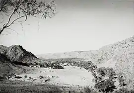 Areyonga settlement in the Northern Territory of Australia (circa 1958) | |||||||||||||||
Areyonga | |||||||||||||||
| Coordinates | 24°05′14″S 132°16′19″E[1] | ||||||||||||||
| Population | 195 (2016 census)[2] | ||||||||||||||
| Established | 1920s | ||||||||||||||
| Postcode(s) | 0872[3] | ||||||||||||||
| Time zone | ACST (UTC+9:30) | ||||||||||||||
| Location |
| ||||||||||||||
| LGA(s) | MacDonnell Region[1] | ||||||||||||||
| Territory electorate(s) | Stuart[4] | ||||||||||||||
| Federal Division(s) | Lingiari[5] | ||||||||||||||
| |||||||||||||||
| Footnotes | Adjoining localities[6][7] | ||||||||||||||
Areyonga was founded during the 1920s. A long drought forced Pitjantatjara families to leave Kaḻṯukatjara and other places in the Petermann Ranges. They originally moved to Hermannsburg and then set up a new community at Areyonga. A Lutheran mission was established in the settlement in the 1940s. In the 1970s, many people from the mission moved back to the community at Kaḻṯukatjara. The Lutheran mission at Areyonga was closed in 1990, and the land was given back to the native people as part of the Haasts Bluff Aboriginal Land Trust.[8]
Areyonga is in the valley of a deep and spectacular gorge, and has an abundant flora and fauna life along its creekbed and waterholes, including a large wild donkey population who bray day and night, adding to the town's charm. It has a thriving Community Arts Centre with sought after artists, and the town encourages visitors (no permit is required, despite notes on outdated maps). It is only a 20 km detour from the Mereenie Loop for visitors coming through from Kings Canyon.
Pitjantjatjara artist, Bill Whiskey Tjapaltjarri worked at Areyonga.[9]
The 2016 Australian census which was conducted in August 2016 reports that Areyonga had 195 people living within its boundaries of which 176 (89.8%) identified as “Aboriginal and/or Torres Strait Islander people.”[2]
Areyonga is located within the federal division of Lingiari, the territory electoral division of Stuart and the local government area of the MacDonnell Region.[5][4][6]
References
- "Place Names Register Extract for Areyonga (locality)". NT Place Names Register. Northern Territory Government. Retrieved 9 April 2020.
- Australian Bureau of Statistics (27 June 2017). "Areyonga (State Suburb)". 2016 Census QuickStats. Retrieved 9 April 2020.

- "Areyonga Postcode". postcode-finders.com.au. Retrieved 9 April 2020.
- "Division of Namatjira". Northern Territory Electoral Commission. Retrieved 9 April 2020.
- "Federal electoral division of Lingiari". Australian Electoral Commission. Retrieved 9 April 2020.
- "Localities within McDonnell Shire (sic) (map)" (PDF). Northern Territory Government. 2 April 2007. Retrieved 9 April 2020.
- "Community of Areyonga (CP 5110)". NT Place Names Register. Northern Territory Government. 5 April 2007. Archived from the original on 4 March 2017. Retrieved 9 April 2020.
- Trengove, Anna (7 November 2011). "Areyonga (1920s - )". Find & Connect. Australian Government, Department of Families, Housing, Community Services and Indigenous Affairs. Retrieved 18 March 2013.
- "Profile". cooeeart.com.au. Cooee Art. Retrieved 11 January 2019.