Arkansas Highway 120
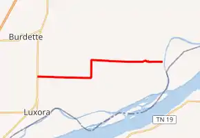
Highway 120 (AR 120, Ark. 120, and Hwy. 120) is an east–west state highway in Mississippi County, Arkansas. The route begins at US Highway 61 (US 61) and the Great River Road at Tuckertown and runs 8.03 miles (12.92 km) east to CR 903 at O'Donnell Bend at a levee along the Mississippi River. The route is maintained by the Arkansas Department of Transportation (ArDOT).
| ||||
|---|---|---|---|---|
| ||||
| Route information | ||||
| Maintained by ArDOT | ||||
| Length | 8.03 mi[1] (12.92 km) | |||
| Existed | c. April 1, 1926-1927[2][3]–present | |||
| Major junctions | ||||
| West end | ||||
| East end | CR 903 at O'Donnell Bend | |||
| Location | ||||
| Counties | Mississippi | |||
| Highway system | ||||
| ||||

Route description
Highway 120 begins at US 61 in eastern Mississippi County within the Arkansas Delta. The route runs east before turning north to Double Bridges, when it turns east and runs as a section line road. Highway 120 crosses Bear Bayou before terminating at County Road 903, which runs along a levee for the Canadian Reach of the Mississippi River.[4]
History
The highway was created after the original 1926 Arkansas state highway numbering, first appearing on the 1927 highway map.[2][3]
Major intersections
The entire route is in Mississippi County.
| Location | mi[1] | km | Destinations | Notes | |
|---|---|---|---|---|---|
| Tuckertown | 0.00 | 0.00 | Western terminus | ||
| O'Donnell Bend | 8.03 | 12.92 | CR 903 | Eastern terminus | |
| 1.000 mi = 1.609 km; 1.000 km = 0.621 mi | |||||
See also
References
- System Information and Research Division (2014). "Arkansas Road Log Database" (MDB). Arkansas State Highway and Transportation Department. Retrieved March 27, 2016.
- Arkansas State Highway Commission (April 1, 1926). Map of State of Arkansas Showing System of State Highways (TIF) (Map). Arkansas State Highway Commission. Retrieved December 7, 2017.
- Arkansas State Highway Commission (1927). Map of State of Arkansas Showing System of State Highways (TIF) (Map). Arkansas State Highway Commission. Retrieved December 7, 2017.
- Arkansas State Highway and Transportation Department (March 23, 2016). General Highway Map, Mississippi County, Arkansas (PDF) (Map). 1:62500. Arkansas State Highway and Transportation Department. Retrieved December 7, 2017.
External links
![]() Media related to Arkansas Highway 120 at Wikimedia Commons
Media related to Arkansas Highway 120 at Wikimedia Commons