Armagh, Pennsylvania
Armagh is a borough in Indiana County in the U.S. state of Pennsylvania. The population was 122 at the 2010 census.
Armagh, Pennsylvania | |
|---|---|
Borough | |
 Location of Armagh in Indiana County, Pennsylvania. | |
 Armagh Location of Armagh in Indiana County, Pennsylvania.  Armagh Armagh (the United States) | |
| Coordinates: 40°27′34″N 79°01′50″W | |
| Country | United States |
| State | Pennsylvania |
| County | Indiana |
| Settled | 1792 |
| Incorporated | 1824 |
| Government | |
| • Type | Borough Council |
| Area | |
| • Total | 0.06 sq mi (0.15 km2) |
| • Land | 0.06 sq mi (0.15 km2) |
| • Water | 0.00 sq mi (0.00 km2) |
| Population (2010) | |
| • Total | 122 |
| • Estimate (2019)[2] | 115 |
| • Density | 2,017.54/sq mi (773.65/km2) |
| Time zone | UTC-5 (Eastern (EST)) |
| • Summer (DST) | UTC-4 (EDT) |
| Zip code | 15920 |
| FIPS code | 42-03032 |
History
Armagh is the oldest community in Indiana County, having been founded in 1792 by eight families led by James and Margaret Jane Graham from Ireland. The community was named after the Irish city and county of Armagh, which was the hometown of some of the settlers. Its first school began in 1799, using a log cabin, and in 1805, it established the county's first post office.[3]
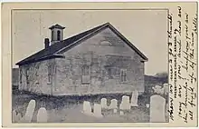
Many of the original settlers were Presbyterian. The Wheatfield Presbyterian Church, later known simply as the Armagh Presbyterian Church, was started in 1786. The Rev. George Hill, its first minister, was installed in 1792, and was shared with churches in Fairfield and Donegal. In 1820 the congregation built a log church and in 1835-6 replaced it with a white frame church. Another Presbyterian church was built in 1905 in Seward, about 3 miles south. The two congregations merged in 1963. The Armagh church building was destroyed in 2004 after being hit by a truck.[4]
The community became a borough on April 10, 1824, having previously been part of East Wheatfield Township.[5] The borough was the birthplace of pioneer American labor leader William H. Sylvis in 1828.[6] Armagh was described in the 1940 Pennsylvania guide as being "settled in 1792 by Irish immigrants, who found the hillside bare except for a few scrubby oaks; hence the name. In stagecoach days Armagh had almost as many taverns as it has houses today."[7]
Geography
Armagh is located at 40°27′13″N 79°1′50″W (40.453549, -79.030500).[8]
According to the United States Census Bureau, the borough has a total area of 0.1 square miles (0.3 km2), all land.
Demographics
| Historical population | |||
|---|---|---|---|
| Census | Pop. | %± | |
| 1850 | 152 | — | |
| 1860 | 190 | 25.0% | |
| 1870 | 177 | −6.8% | |
| 1880 | 123 | −30.5% | |
| 1890 | 162 | 31.7% | |
| 1900 | 131 | −19.1% | |
| 1910 | 82 | −37.4% | |
| 1920 | 110 | 34.1% | |
| 1930 | 123 | 11.8% | |
| 1940 | 163 | 32.5% | |
| 1950 | 176 | 8.0% | |
| 1960 | 192 | 9.1% | |
| 1970 | 165 | −14.1% | |
| 1980 | 133 | −19.4% | |
| 1990 | 104 | −21.8% | |
| 2000 | 131 | 26.0% | |
| 2010 | 122 | −6.9% | |
| 2019 (est.) | 115 | [2] | −5.7% |
| Sources:[9][10] | |||
As of the census[11] of 2000, there were 131 people, 54 households, and 40 families residing in the borough. The population density was 2,301.9 people per square mile (843.0/km²). There were 59 housing units at an average density of 1,036.7 per square mile (379.7/km²). The racial makeup of the borough was 100.00% White.
There were 54 households, out of which 24.1% had children under the age of 18 living with them, 61.1% were married couples living together, 9.3% had a female householder with no male present, and 24.1% were non-families. 24.1% of all households were made up of individuals, and 11.1% had someone living alone who was 65 years of age or older. The average household size was 2.43 and the average family size was 2.83.
In the borough the population was spread out, with 18.3% under the age of 18, 10.7% from 18 to 24, 27.5% from 25 to 44, 23.7% from 45 to 64, and 19.8% who were 65 years of age or older. The median age was 42 years. For every 100 females there were 98.5 males. For every 100 females age 18 and over, there were 98.1 males.
The median income for a household in the borough was $31,806, and the median income for a family was $34,167. Males had a median income of $30,833 versus $24,167 for females. The per capita income for the borough was $18,309. There were 7.1% of families and 10.9% of the population living below the poverty line, including 20.0% of under eighteens and 6.9% of those over 64.
References
- "2019 U.S. Gazetteer Files". United States Census Bureau. Retrieved July 28, 2020.
- "Population and Housing Unit Estimates". United States Census Bureau. May 24, 2020. Retrieved May 27, 2020.
- Busovicki, John F. (2003). Indiana County. Charleston, South Carolina: Arcadia Publishing. p. 72. ISBN 0-7385-1181-1.
- DelFavero, Gina (4 July 2013). "Armagh-Seward Presbyterian Church observes 50th anniversary of merger". Pittsburgh Tribune-Review. Retrieved 15 June 2015.
- "Indiana County (Dates of incorporation of municipalities)" (PDF). Pennsylvania Historical and Museum Commission. Retrieved 2008-05-20.
- Donald G. Sofchalk, "William H. Sylvis," in Gary M. Fink (ed.), Biographical Dictionary of American Labor. Second edition. Westport, CT: Greenwood Press, 1984; pg. 541.
- Federal Writers' Project (1940). Pennsylvania: A Guide to the Keystone State (1st ed.). New York: Oxford University Press. pp. 393–394.
- "US Gazetteer files: 2010, 2000, and 1990". United States Census Bureau. 2011-02-12. Retrieved 2011-04-23.
- "Census of Population and Housing: Decennial Censuses". United States Census Bureau. Retrieved 2012-03-04.
- "Incorporated Places and Minor Civil Divisions Datasets: Subcounty Resident Population Estimates: April 1, 2010 to July 1, 2012". Population Estimates. U.S. Census Bureau. Archived from the original on 11 June 2013. Retrieved 11 December 2013.
- "U.S. Census website". United States Census Bureau. Retrieved 2008-01-31.
Municipalities and communities of Indiana County, Pennsylvania, United States | ||
|---|---|---|
| Boroughs | 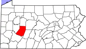 | |
| Townships | ||
| CDPs | ||
| Unincorporated communities | ||
| ||
| Counties |  Map of the Pittsburgh Tri-State with green counties in the metropolitan area and yellow counties in the combined area | |
|---|---|---|
| Major cities | ||
| Cities and towns 15k–50k (in 2010) | ||
| Airports | ||
| Topics | ||
| ||