Brooke County, West Virginia
Brooke County is a county in the Northern Panhandle of the U.S. state of West Virginia. As of the 2010 census, the population was 24,069.[1] Its county seat is Wellsburg.[2] The county was created in 1797 from part of Ohio County[3] and named in honor of Robert Brooke, Governor of Virginia from 1794 to 1796.[4] Brooke County is part of the Weirton-Steubenville, WV-OH Metropolitan Statistical Area, which is also included in the Pittsburgh-New Castle-Weirton, PA-WV-OH Combined Statistical Area.[5]
Brooke County | |
|---|---|
 | |
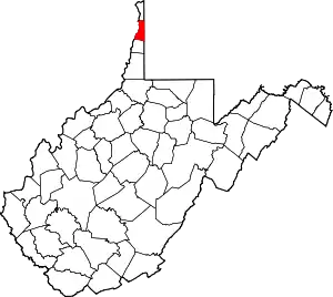 Location within the U.S. state of West Virginia | |
 West Virginia's location within the U.S. | |
| Coordinates: 40°16′N 80°35′W | |
| Country | |
| State | |
| Founded | November 30, 1797 |
| Named for | Robert Brooke |
| Seat | Wellsburg |
| Largest city | Follansbee |
| Area | |
| • Total | 93 sq mi (240 km2) |
| • Land | 89 sq mi (230 km2) |
| • Water | 3.4 sq mi (9 km2) 3.6%% |
| Population (2010) | |
| • Total | 24,069 |
| • Estimate (2019) | 21,939 |
| • Density | 260/sq mi (100/km2) |
| Time zone | UTC−5 (Eastern) |
| • Summer (DST) | UTC−4 (EDT) |
| Congressional district | 1st |
| Website | www |
History
The Ohio Company of Virginia petitioned the British King for 500,000 acres of land in the Ohio River Valley in 1747, but the first settlers to this area, in what later became known as West Virginia's Northern Panhandle, were brothers Jonathan, Israel and Friend Cox. They staked a "tomahawk claim" to 1200 acres (400 acres for each brother) at the mouth of Buffalo Creek[6] and extending along the Ohio River. Their cousin George Cox staked an adjacent claim a few years later.
In 1788 Charles Prather purchased 481 acres from Friend Cox's heir, John Cox; by that year's end Alexander Wells, formerly of Baltimore, Maryland and later of Cross Creek Township, Pennsylvania, established a trading post (together with his Baltimore cousin Richard Owings). In 1791 the Ohio County Court incorporated the town around the post as "Charlestown" (after Prather's first name). On November 30, 1796 the Virginia General Assembly formed Brooke County, from parts of Ohio County, and designated "Charlestown" as the county seat. Across the Appalachian Continental Divide to the east in Jefferson County, another Charlestown had previously been incorporated (it is now known as Charles Town). In addition, Charleston had been established at the confluence of the Elk and Kanawha rivers in 1788.
Addressing this confusion, the Virginia General Assembly on December 28, 1816 changed the Brooke county seat's name from "Charlestown" to Wellsburg, supposedly to honor Charles Wells, Prather's son-in-law.[7] The first Masonic Lodge west of the Allegheny Mountains was established in Wellsburg on March 4, 1799. It was under the jurisdiction of the Grand Lodge of Pennsylvania for six years, but since December 17, 1817, it has been under the jurisdiction of the Grand Lodge of Virginia and later of West Virginia.[8]
The first glass factory in Wellsburg was built in 1813, taking advantage of the relatively easy transportation on the Ohio River. When the National Road was built about five years later, its first crossing of the Ohio River was via a ferry further west. In 1818 Alexander Campbell founded the first Virginia school west of the Appalachians, which the Virginia General Assembly chartered in 1840 as Bethany College.
During the American Civil War, Brooke County's elected officials helped found the new state of West Virginia, after their efforts to block secession failed at the Virginia Secession Convention of 1861. Wellsburg received a new charter in 1866 from the newly established West Virginia legislature, and Samuel Marks became Wellsburg's first elected mayor.[9]
In 1863, West Virginia's counties were divided into civil townships, with the intention of encouraging local government. This proved impractical in the heavily rural state, and in 1872 the townships were converted into magisterial districts.[10] Brooke County was divided into three districts: Buffalo, Cross Creek, and Wellsburg. Wellsburg District was co-extensive with the city of Wellsburg. The districts of Follansbee and Weirton were created between 1970 and 1980. Buffalo and Cross Creek Districts were discontinued in 2008.[11]
Geography
According to the U.S. Census Bureau, the county has a total area of 93 square miles (240 km2), of which 89 square miles (230 km2) is land and 3.4 square miles (8.8 km2) (3.6%) is water.[12] It is the second-smallest county in West Virginia by area. The highest point of elevation in Brooke County is approximately 1372 ft. and located about 1.5 miles south of Franklin.
Adjacent counties
- Hancock County (north)
- Washington County, Pennsylvania (east)
- Ohio County (south)
- Jefferson County, Ohio (west)
National protected area
Demographics
| Historical population | |||
|---|---|---|---|
| Census | Pop. | %± | |
| 1800 | 4,706 | — | |
| 1810 | 5,843 | 24.2% | |
| 1820 | 6,631 | 13.5% | |
| 1830 | 7,041 | 6.2% | |
| 1840 | 7,948 | 12.9% | |
| 1850 | 5,054 | −36.4% | |
| 1860 | 5,494 | 8.7% | |
| 1870 | 5,464 | −0.5% | |
| 1880 | 6,013 | 10.0% | |
| 1890 | 6,660 | 10.8% | |
| 1900 | 7,219 | 8.4% | |
| 1910 | 11,098 | 53.7% | |
| 1920 | 16,527 | 48.9% | |
| 1930 | 24,663 | 49.2% | |
| 1940 | 25,513 | 3.4% | |
| 1950 | 26,904 | 5.5% | |
| 1960 | 28,940 | 7.6% | |
| 1970 | 29,685 | 2.6% | |
| 1980 | 31,117 | 4.8% | |
| 1990 | 26,992 | −13.3% | |
| 2000 | 25,447 | −5.7% | |
| 2010 | 24,069 | −5.4% | |
| 2019 (est.) | 21,939 | [13] | −8.8% |
| U.S. Decennial Census[14] 1790–1960[15] 1900–1990[16] 1990–2000[17] 2010–2019[1] | |||
2000 census
As of the census[18] of 2000, there were 25,447 people, 10,396 households, and 7,152 families living in the county. The population density was 286 people per square mile (111/km2). There were 11,150 housing units at an average density of 126 per square mile (48/km2). The racial makeup of the county was 97.90% White, 0.85% Black or African American, 0.10% Native American, 0.34% Asian, 0.04% Pacific Islander, 0.09% from other races, and 0.69% from two or more races. 0.39% of the population were Hispanic or Latino of any race.
There were 10,396 households, out of which 26.90% had children under the age of 18 living with them, 55.30% were married couples living together, 9.90% had a female householder with no husband present, and 31.20% were non-families. 27.90% of all households were made up of individuals, and 14.40% had someone living alone who was 65 years of age or older. The average household size was 2.36 and the average family size was 2.88.
In the county, the population was spread out, with 20.40% under the age of 18, 9.40% from 18 to 24, 25.80% from 25 to 44, 26.00% from 45 to 64, and 18.30% who were 65 years of age or older. The median age was 41 years. For every 100 females there were 91.80 males. For every 100 females age 18 and over, there were 89.90 males.
The median income for a household in the county was $32,981, and the median income for a family was $39,948. Males had a median income of $34,397 versus $19,711 for females. The per capita income for the county was $17,131. About 9.50% of families and 11.70% of the population were below the poverty line, including 16.40% of those under age 18 and 9.10% of those age 65 or over.
2010 census
As of the 2010 United States Census, there were 24,069 people, 10,020 households, and 6,636 families living in the county.[19] The population density was 269.8 inhabitants per square mile (104.2/km2). There were 10,967 housing units at an average density of 122.9 per square mile (47.5/km2).[20] The racial makeup of the county was 97.0% white, 1.2% black or African American, 0.4% Asian, 0.1% American Indian, 0.2% from other races, and 1.1% from two or more races. Those of Hispanic or Latino origin made up 0.7% of the population.[19] In terms of ancestry, 21.5% were German, 17.5% were Irish, 16.4% were Italian, 11.5% were English, 7.2% were American, 5.9% were Scotch-Irish, and 5.7% were Polish.[21]
Of the 10,020 households, 25.8% had children under the age of 18 living with them, 50.7% were married couples living together, 10.7% had a female householder with no husband present, 33.8% were non-families, and 29.2% of all households were made up of individuals. The average household size was 2.32 and the average family size was 2.83. The median age was 44.8 years.[19]
The median income for a household in the county was $39,475 and the median income for a family was $52,528. Males had a median income of $39,065 versus $29,824 for females. The per capita income for the county was $22,377. About 7.9% of families and 11.0% of the population were below the poverty line, including 16.5% of those under age 18 and 7.8% of those age 65 or over.[22]
Law and government
Brooke County is governed by a three-member County Commission who each serve in rotating 6-year terms. The terms are designed such that one seat is up for election in even years. The County Commission annually chooses its own President. The Brooke County Commissioners in 2008 are President Bernard Kazienko, Marty Bartz, and Norma Tarr.[23][24]
Brooke County is part of the First Judicial Circuit of West Virginia, which also includes Hancock and Ohio counties. In West Virginia, Circuit Judges are elected in non-partisan elections to eight-year terms. The current judges of the First Judicial Circuit are the Hon. Jason A. Cuomo, the Hon. James Mazzone, the Hon. David J. Sims, and the Hon. Ronald E. Wilson. All four Circuit Court judges were re-elected in November 2016.
Brooke County is part of the First Family Court Circuit of West Virginia which also includes Hancock and Ohio Counties. In West Virginia, Family Court Judges were first elected to six-year terms beginning in 2002 and were elected to eight-year terms beginning in 2008. The current judges of the First Family Court Circuit are the Hon. Joyce Chernenko and the Hon. William Sinclair who were both elected to eight-year terms in November 2008.[25]
Magistrates are elected in partisan elections serving four-year terms. Vacancies occurring in unexpired terms can be filled by a respective Circuit Court Judge. Unlike Circuit Court judges or Family Court judges, magistrates are not required to be attorneys. Brooke County currently has two magistrates: Robin Snyder and Danielle Diserio.[25]
Politics
Abutting free states Ohio and Pennsylvania, and with a largely German-American culture unlike any other part of antebellum Virginia,[26] Brooke County and the rest of the Northern Panhandle were central to the vanguard who made West Virginia a new state during the Civil War.[27] For the next six and a half decades the county, aided by its association with Pennsylvania's powerful ironmonger-led Republican machines, voted solidly Republican to the point of supporting William Howard Taft during the disastrously divided 1912 election. From the New Deal until Bill Clinton, however, powerful unionization meant that Brooke County turned from solidly Republican to solidly Democratic except when the Democrats nominated the liberal George McGovern in 1972. Like all of West Virginia, since 2000 a combination of declining unionization[28] and differences with the Democratic Party's liberal views on social issues[29] has produced a dramatic swing to the Republican Party.
| Year | Republican | Democratic | Third parties |
|---|---|---|---|
| 2020 | 70.8% 7,545 | 27.7% 2,947 | 1.5% 164 |
| 2016 | 68.3% 6,625 | 26.5% 2,568 | 5.2% 503 |
| 2012 | 54.3% 5,060 | 42.9% 4,005 | 2.8% 263 |
| 2008 | 50.3% 4,961 | 47.9% 4,717 | 1.8% 179 |
| 2004 | 48.2% 5,189 | 51.0% 5,493 | 0.8% 91 |
| 2000 | 44.6% 4,195 | 49.7% 4,678 | 5.7% 532 |
| 1996 | 28.9% 2,741 | 56.2% 5,338 | 15.0% 1,421 |
| 1992 | 24.8% 2,582 | 54.7% 5,693 | 20.6% 2,140 |
| 1988 | 38.9% 4,006 | 60.7% 6,258 | 0.4% 42 |
| 1984 | 41.9% 4,819 | 57.7% 6,636 | 0.4% 43 |
| 1980 | 39.2% 4,622 | 54.5% 6,430 | 6.3% 743 |
| 1976 | 36.9% 4,792 | 63.1% 8,197 | |
| 1972 | 59.1% 7,544 | 40.9% 5,226 | |
| 1968 | 31.9% 4,191 | 57.1% 7,506 | 11.0% 1,444 |
| 1964 | 25.5% 3,364 | 74.5% 9,834 | |
| 1960 | 42.3% 5,754 | 57.7% 7,838 | |
| 1956 | 45.7% 5,944 | 54.3% 7,072 | |
| 1952 | 40.1% 5,073 | 59.9% 7,591 | |
| 1948 | 35.4% 3,718 | 63.6% 6,680 | 1.1% 114 |
| 1944 | 38.5% 3,588 | 61.5% 5,726 | |
| 1940 | 38.4% 4,004 | 61.6% 6,416 | |
| 1936 | 36.7% 3,485 | 62.7% 5,955 | 0.6% 55 |
| 1932 | 43.6% 4,010 | 53.4% 4,919 | 3.0% 277 |
| 1928 | 68.1% 5,277 | 31.2% 2,419 | 0.6% 48 |
| 1924 | 59.3% 3,858 | 31.3% 2,037 | 9.3% 606 |
| 1920 | 57.4% 3,060 | 39.9% 2,129 | 2.7% 146 |
| 1916 | 50.7% 1,422 | 45.0% 1,261 | 4.3% 120 |
| 1912 | 38.6% 972 | 33.7% 850 | 27.7% 697 |
Education
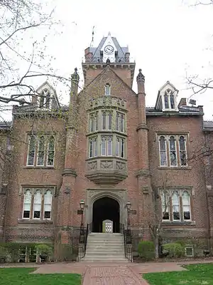
Brooke County is the home of Bethany College which is the oldest private college in the state.
Communities
Cities
- Follansbee
- Weirton (part)
- Wellsburg (county seat)
Town
Villages
Current
- Follansbee
- Weirton
- Wellsburg
Historic
- Buffalo
- Cross Creek
Census-designated places
Unincorporated communities
See also
References
- "State & County QuickFacts". United States Census Bureau. Archived from the original on July 7, 2011. Retrieved January 9, 2014.
- "Find a County". National Association of Counties. Archived from the original on May 31, 2011. Retrieved June 7, 2011.
- "West Virginia: Individual County Chronologies". West Virginia Atlas of Historical County Boundaries. The Newberry Library. 2003. Retrieved August 10, 2015.
- "Archived copy". Archived from the original on October 22, 2012. Retrieved January 29, 2013.CS1 maint: archived copy as title (link)
- http://www.whitehouse.gov/sites/default/files/omb/bulletins/2013/b13-01.pdf
- TX, Jean Suplick Matuson, Plano. "Washington Co., PA - Geography". www.chartiers.com. Retrieved March 27, 2018.
- Nancy L. Caldwell, A History of Brooke County, (Brooke County Historical Society, 1975), p. 4
- Caldwell, p. 5
- Caldwell, p. 4 et seq
- Otis K. Rice & Stephen W. Brown, West Virginia: A History, 2nd ed., University Press of Kentucky, Lexington (1993), p. 240.
- United States Census Bureau, U.S. Decennial Census, Tables of Minor Civil Divisions in West Virginia, 1870–2010.
- "2010 Census Gazetteer Files". United States Census Bureau. August 22, 2012. Retrieved July 23, 2015.
- "Population and Housing Unit Estimates". Retrieved March 29, 2020.
- "U.S. Decennial Census". United States Census Bureau. Retrieved January 9, 2014.
- "Historical Census Browser". University of Virginia Library. Retrieved January 9, 2014.
- "Population of Counties by Decennial Census: 1900 to 1990". United States Census Bureau. Retrieved January 9, 2014.
- "Census 2000 PHC-T-4. Ranking Tables for Counties: 1990 and 2000" (PDF). United States Census Bureau. Retrieved January 9, 2014.
- "U.S. Census website". United States Census Bureau. Retrieved May 14, 2011.
- "DP-1 Profile of General Population and Housing Characteristics: 2010 Demographic Profile Data". United States Census Bureau. Archived from the original on February 13, 2020. Retrieved April 3, 2016.
- "Population, Housing Units, Area, and Density: 2010 - County". United States Census Bureau. Archived from the original on February 13, 2020. Retrieved April 3, 2016.
- "DP02 SELECTED SOCIAL CHARACTERISTICS IN THE UNITED STATES – 2006-2010 American Community Survey 5-Year Estimates". United States Census Bureau. Archived from the original on February 13, 2020. Retrieved April 3, 2016.
- "DP03 SELECTED ECONOMIC CHARACTERISTICS – 2006-2010 American Community Survey 5-Year Estimates". United States Census Bureau. Archived from the original on February 13, 2020. Retrieved April 3, 2016.
- "Tarr Out in Brooke County". The Intelligencer. Retrieved July 17, 2017.
- "Obituaries: Bernard 'Bernie' L. Kaziensko". Reasner Funeral House. Retrieved July 17, 2017.
- See West Virginia Secretary of State; Election Results Center
- MacKenzie, Scott; ‘The Fifth Border State: Slavery and the Formation of West Virginia, 1850-1868’ (thesis), Auburn University Electronic Theses and Dissertations
- Link, William A.; ‘This Bastard New Virginia: Slavery, West Virginia Exceptionalism, and the Secession Crisis’
- Schwartzman, Gabe; ‘How Central Appalachia Went Right’; Daily Yonder, January 13, 2015
- Cohn, Nate; ‘Demographic Shift: Southern Whites’ Loyalty to G.O.P. Nearing That of Blacks to Democrats’, The New York Times, April 24, 2014
- Leip, David. "Dave Leip's Atlas of U.S. Presidential Elections". uselectionatlas.org. Retrieved March 27, 2018.
External links
- Official Brooke County Website
- Brooke County Schools
- Brooke County Public Library
- Brooke County Economic Development Homepage
- Top of WV CVB, the Convention & Visitors Bureau for Brooke and Hancock Counties
Places adjacent to Brooke County, West Virginia | ||||||||||
|---|---|---|---|---|---|---|---|---|---|---|
| ||||||||||
Municipalities and communities of Brooke County, West Virginia, United States | ||
|---|---|---|
| Cities | Map of West Virginia highlighting Brooke County | |
| Town | ||
| Villages | ||
| CDP | ||
| Unincorporated communities | ||
| Footnotes | ‡This populated place also has portions in an adjacent county or counties | |
| ||

| Authority control |
|---|