Armour, Ontario
Armour (2016 population 1,414) is a township municipality in the Canadian province of Ontario.[2][5][6]
Armour | |
|---|---|
| Township of Armour | |
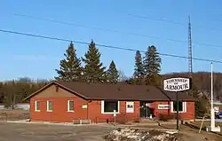 Municipal office | |
| Etymology: John Douglas Armour.[1] | |
 Armour Location in Southern Ontario | |
| Coordinates: 45°37′44″N 79°20′38″W[2] | |
| Country | Canada |
| Province | Ontario |
| District | Parry Sound |
| Incorporated | 1998 |
| Government | |
| • Type | Township |
| • Reeve | Bob MacPhail |
| • MP | Scott Aitchison (CPC) |
| • MPP | Norm Miller (OPC) |
| Area | |
| • Land | 164.64 km2 (63.57 sq mi) |
| Population (2016)[4] | |
| • Total | 1,414 |
| • Density | 8.6/km2 (22/sq mi) |
| Time zone | UTC-5 (EST) |
| • Summer (DST) | UTC-4 (EDT) |
| Postal code span | P0A |
| Area codes | 705, 249 |
| Website | www |
Located in the Almaguin Highlands region of Parry Sound District, the township surrounds but does not include the village of Burk's Falls. It was named in honour of Judge John Douglas Armour.[1]
Communities
The township includes the communities of Berriedale, Carss, Chetwynd, Katrine and Pickerel Lake.
Katrine overlooks Doe Lake, which is located on the west side of the village. Three Mile Lake and Deer Lake are located about 5 km east of the village. There is also a small public beach on Doe Lake, and a community centre located on Ontario Highway 11.[7]
Demographics
| Year | Pop. | ±% |
|---|---|---|
| 1991 | 1,403 | — |
| 1996 | 1,464 | +4.3% |
| 2001 | 1,326 | −9.4% |
| 2006 | 1,249 | −5.8% |
| 2011 | 1,372 | +9.8% |
| 2016 | 1,414 | +3.1% |
| [8][3][4] | ||
Private dwellings occupied by usual residents: 610 (total dwellings: 1,080)[4]
Mother tongue (2006):[9]
- English as first language: 92.4%
- French as first language: 2.4%
- English and French as first language: 0%
- Other as first language: 5.2%
References
- "The Honourable Mr. Justice John Douglas Armour". Township of Armour. Archived from the original on 2011-07-06. Retrieved 2010-08-17.
- "Armour". Geographical Names Data Base. Natural Resources Canada. Retrieved 2021-01-09.
- Statistics Canada 2011 Census - Armour Census Profile
- "Census Profile, 2016 Census: Armour, Township". Statistics Canada. Retrieved June 28, 2019.
- "Ontario Geonames GIS (on-line map and search)". Ontario Ministry of Natural Resources and Forestry. 2014. Retrieved 2021-01-09.
- Restructured municipalities - Ontario map #4 (Map). Restructuring Maps of Ontario. Ontario Ministry of Municipal Affairs and Housing. 2006. Retrieved 2021-01-09.
- "Katrine Ontario". Almaguin Communities. Almaguin Highlands Ontario Inc. Retrieved 2009-01-07.
- Statistics Canada: 1996, 2001, 2006
- "2006 Armour community profile".
External links
- Official website

- Katrine Ontario Almaguin Highlands Regional Portal
| Towns | 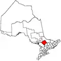 | |
|---|---|---|
| Townships | ||
| Villages | ||
| First Nations | ||
| Indian reserves | ||
| Local services boards | ||
| Unorganized areas | ||
| ||
